Gibraltar has a limited public transport system, due to the compact size of the territory.

Europa Point, is the southernmost point of Gibraltar. Although not the southernmost point of the Iberian Peninsula, Europa Point defines the boundary between the Straits of Gibraltar in the Atlantic Ocean, and the Alboran Sea within the Mediterranean. At the end of the Rock of Gibraltar, the area is flat and occupied by such features as a playing field and a few buildings. On a clear day, views of North Africa can be seen across the Strait of Gibraltar including Ceuta and the Rif Mountains of Morocco; as well as the Bay of Gibraltar and the Spanish towns along its shores. It is reached from the old town by Europa Road.

Catalan Bay is a bay and fishing village in Gibraltar, on the eastern side of The Rock away from Westside.

Sandy Bay is a village, bay and beach located on a small bay on the eastern Mediterranean coast of Gibraltar, on the opposite side of The Rock from the main city. It is situated to the south of Catalan Bay and is accessible via Sir Herbert Miles Road.

Gibraltar International Airport, previously known as North Front Airport, is the civilian airport that serves the British overseas territory of Gibraltar. The runway and aerodrome is owned by the Ministry of Defence (MoD), and operated by the Royal Air Force (RAF) as RAF Gibraltar. Civilian operators use the civilian-operated terminal. National Air Traffic Services (NATS) hold the contract for provision of air navigation services at the airport.

The Monte Viso Tunnel is an Alpine pedestrian tunnel excavated in the rock during the Renaissance and located eight kilometres north of Monviso, northern Italy. It is 75 m long, 3 m wide, and located at an altitude of 2,882 metres linking the villages of Crissolo in the modern Italian province of Cuneo and Ristolas in the French department of Hautes-Alpes.

Gibraltar is a British Overseas Territory and city located at the southern tip of the Iberian Peninsula. It has an area of 6.7 km2 (2.6 sq mi) and is bordered to the north by Spain. The landscape is dominated by the Rock of Gibraltar, at the foot of which is a densely populated town area, home to some 32,688 people, primarily Gibraltarians.

Tourism in Gibraltar constitutes one of the British Overseas Territory's most important economic pillars, alongside financial services and shipping. Gibraltar's main attractions are the Rock of Gibraltar and its resident population of Barbary macaques, the territory's military heritage, duty-free shopping, casinos and marinas. Although the population of Gibraltar numbers only some 30,000 people, the territory recorded nearly 12 million visits in 2011, giving it one of the highest tourist-to-resident ratios in the world.
Dudley Ward may refer to:

The Europa Point Lighthouse, also referred to as the Trinity Lighthouse at Europa Point and the Victoria Tower or La Farola in Llanito, is a lighthouse at Europa Point, on the southeastern tip of the British Overseas Territory of Gibraltar, on the southern end of the Iberian Peninsula, at the entrance to the Mediterranean Sea.

Williams Way is a tunnel through the eastern part of the Rock of Gibraltar.

Profield Contractors, also referred to as Profield Contractors Ltd, is a Gibraltar-based construction company founded in 1989. The company has worked on a number of general construction and civil engineering projects in Gibraltar.

Nun's Well is an ancient underground water reservoir in the British Overseas Territory of Gibraltar. It is located at Europa Point, and is thought to be of the Moorish period. It represents some of the earliest evidence of an artificial water supply in Gibraltar. The name of the cistern is thought to be derived from the nuns associated with the Shrine of Our Lady of Europe. In the eighteenth century, Nun's Well supplied the military with water. In the early nineteenth century, it provided water for the brewery that was built next door. In 1988, the Royal Engineers constructed what is now the main building, which has a castle-like appearance. Nun's Well became the focus of controversy during the 2010-2011 restoration of the site.

Streets in the British Overseas Territory of Gibraltar are represented by road signs as in the United Kingdom. As of 2007, Gibraltar has a network of 29 kilometres (18 mi) of roads.
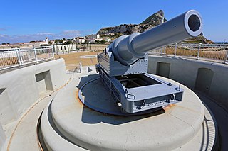
Harding's Battery is a restored artillery battery in the British Overseas Territory of Gibraltar. It is located at Europa Point and includes the Europa Sunken Magazine that is now used as a visitor centre.

Keightley Way is a southwestern road and tunnel in the British Overseas Territory of Gibraltar. It connects Rosia Road at Little Bay to the Ibrahim-al-Ibrahim Mosque and Nun's Well at Europa Point. Dug in 1960, it was the last surface tunnel to be built in Gibraltar. The tunnel was designed to take a two lane road and space for pedestrians, although it now only carries one lane of traffic southbound. It was named after General Sir Charles Keightley who was the Governor of Gibraltar at the time.

The Gibraltar peninsula, located at the far southern end of Iberia, has great strategic importance as a result of its position by the Strait of Gibraltar where the Mediterranean Sea meets the Atlantic Ocean. It has repeatedly been contested between European and North African powers and has endured fourteen sieges since it was first settled in the 11th century. The peninsula's occupants – Moors, Spanish, and British – have built successive layers of fortifications and defences including walls, bastions, casemates, gun batteries, magazines, tunnels and galleries. At their peak in 1865, the fortifications housed around 681 guns mounted in 110 batteries and positions, guarding all land and sea approaches to Gibraltar. The fortifications continued to be in military use until as late as the 1970s and by the time tunnelling ceased in the late 1960s, over 34 miles (55 km) of galleries had been dug in an area of only 2.6 square miles (6.7 km2).

The Great North Road is a large road tunnel in the British Overseas Territory of Gibraltar. It was constructed by the British military during World War II inside the Rock of Gibraltar and remains property of the Ministry of Defence to this day. The road allowed lorries to travel from the north to the south of Gibraltar entirely within the Rock. The tunnel still contains the remains of World War II buildings such as Nissen huts, kitchens, offices as well as a generating station and period anti-submarine nets.

The tunnels of Gibraltar were constructed over the course of nearly 200 years, principally by the British Army. Within a land area of only 2.6 square miles (6.7 km2), Gibraltar has around 34 miles (55 km) of tunnels, nearly twice the length of its entire road network. The first tunnels, excavated in the late 18th century, served as communication passages between artillery positions and housed guns within embrasures cut into the North Face of the Rock. More tunnels were constructed in the 19th century to allow easier access to remote areas of Gibraltar and accommodate stores and reservoirs to deliver the water supply of Gibraltar.
