
The Cathedral of Saint Mary the Crowned is a Latin Catholic cathedral in Gibraltar. It is the primary centre of Catholic worship in the Diocese of Gibraltar.
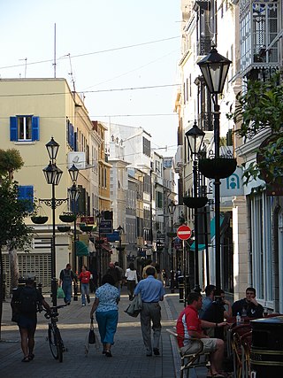
Main Street is the main arterial street in the British overseas territory of Gibraltar.

The Commissioners for the Victualling of the Navy, often called the Victualling Commissioners or Victualling Board, was the body responsible under the Navy Board for victualling ships of the British Royal Navy. It oversaw the vast operation of providing naval personnel with enough food, drink and supplies to keep them fighting fit, sometimes for months at a time, in whatever part of the globe they might be stationed. It existed from 1683 until 1832 when its function was first replaced by the Department of the Comptroller of Victualling and Transport Services until 1869 then that office was also abolished and replaced by the Victualling Department.
Aaron Nunez Cardozo, GMH (1762–1834) was an English businessman who was consul for Tunis and Algiers in Gibraltar around 1805.

Mesod Benady MBE is a Gibraltarian historian of Sephardic Jewish descent. He currently lives in Grendon, Northamptonshire in the United Kingdom.

Lieutenant-General Sir Herbert Scott Gould Miles, was a senior British Army officer. He was Quartermaster-General to the Forces from 1908 to 1912, and Governor of Gibraltar from 1913 until 1918 during the First World War.
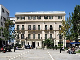
The Gibraltar City Hall is the former city hall for Gibraltar, centrally located within the city at the west end of John Mackintosh Square. It is the office of the Mayor of Gibraltar and since 2023 has been the location of the Registry of Marriages.

John Mackintosh Square is a main square in the British overseas territory of Gibraltar. It has been the centre of city life since the 14th century and takes its name from John Mackintosh, a local philanthropist. Notable buildings on John Mackintosh Square include the Parliament Building and the City Hall.

Rosia Bay is the only natural harbour in Gibraltar, the British Overseas Territory at the southern end of the Iberian Peninsula. Formerly referred to as Rosia Harbour, it is located on the southwest side of Gibraltar. Rosia Bay was the site of the Royal Navy Victualling Yard complex which was constructed in the early 19th century, allowing vessels to anchor and obtain provisions, including food and water. Vice Admiral Horatio Nelson obtained supplies for his Mediterranean Fleet at Rosia Bay. It was to that same anchorage that his vessel HMS Victory was towed after Nelson's death in the 1805 Battle of Trafalgar. The area is also the location of gun batteries, including Parson's Lodge Battery at the south end of the bay and Napier of Magdala Battery at the north end. In the 21st century, Rosia Bay was the focus of controversy following the government's demolition of the historic Rosia Water Tanks and construction of the affordable housing development Nelson's View, which necessitated the relocation of the owners of the adjacent 19th century Rosia Cottages.
The four active synagogues of Gibraltar are colloquially known as the Great Synagogue, the Little Synagogue, the Flemish Synagogue, and the Abudarham Synagogue. The first synagogue established after the 1717 expulsion of Jews from Gibraltar, the Great Synagogue, was built on what is now known as Engineer Lane, and remains Gibraltar's principal synagogue. The Little Synagogue, founded in 1759 in Irish Town, was the result of the desire of Moroccan Jews for a less formal service. The lavish Flemish Synagogue was built at the turn of the nineteenth century on Line Wall Road, due to the request of some congregants for a return to more formal, Dutch customs. The last synagogue to be established in what is now the British overseas territory of Gibraltar, the Abudarham Synagogue, was founded in 1820 on Parliament Lane by recent Moroccan immigrants.
The Rosia Water Tanks were large water tanks built at the turn of the nineteenth century at Rosia Bay in the British Overseas Territory of Gibraltar. They were constructed based on the recommendation by Admiral John Jervis, 1st Earl of St Vincent that the Victualling Yard complex be relocated to Rosia Bay. The complex allowed Royal Navy vessels to obtain both food and water at one site. The Rosia Water Tanks remained in the possession of the Ministry of Defence until 2004, at which time they were transferred to the Government of Gibraltar. Despite local and international criticism, and a court case brought by the Gibraltar Heritage Trust, the tanks were demolished in 2006 to make way for affordable housing. When developer OEM International's funding proved insufficient to complete the project the government repossessed the site.

The Victualling Yard was a victualling facility in the British Overseas Territory of Gibraltar built for supplying Royal Navy ships while anchored at Rosia Bay.

Cathedral Square is a square within the city centre of the British Overseas Territory of Gibraltar. It is the location of the Church of England Cathedral of the Holy Trinity which stands to the eastern end of the square. Other features at the square include Duke of Kent House home to the Gibraltar Tourist Board, the Bristol Hotel a children's play park and Sir Herbert Miles Promenade, which is a boulevard lined with nine cannon overlooking the harbour.

Streets in the British Overseas Territory of Gibraltar are represented by road signs as in the United Kingdom. As of 2007, Gibraltar has a network of 29 kilometres (18 mi) of roads.

Grand Casemates Gates, formerly Waterport Gate, provide an entrance from the northwest to the old, fortified portion of the city of the British Overseas Territory of Gibraltar, at Grand Casemates Square.

The John Mackintosh Hall, known as the John Mac Hall to locals, is the main cultural centre in the British Overseas Territory of Gibraltar. It consists of a public library, a theatre, conference hall, and several multi-purpose spaces.
Grand Casemates Square is the larger of the two main squares within the city centre of Gibraltar. The square takes its name from the British-built Grand Casemates, a casemate and bombproof barracks at the northern end of the square completed in 1817.
Sir Herbert Miles Promenade served as an artillery battery in the British Overseas Territory of Gibraltar.

Town Range is a major road in the British Overseas Territory of Gibraltar. It is located in the old town area and runs parallel to Main Street and part of Prince Edward's Road. It is also known in Spanish as Calle Cuartel, in reference to the barracks constructed on the street in 1740. It is one of the three main parallel streets in the old town and is likely to date back to the Moorish period. Until the mid-19th century it was notorious for its filthiness due to wholly inadequate sanitation and lack of any running water supply. It was the point of outbreak of Gibraltar's devastating 1804 epidemic of yellow fever, which killed a third of the territory's population. The street is now a residential and commercial area notable for several important public buildings in addition to the old Georgian barracks, which have been converted for civilian use.


