Gibraltar has a limited public transport system, due to the compact size of the territory.

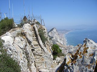
The Rock of Gibraltar is a monolithic limestone mountain 426 m (1,398 ft) high dominating the western entrance to the Mediterranean Sea. It is situated near the end of a narrow 9 kilometres (5.6 mi) long promontory stretching due south into the Mediterranean Sea and is located within the British territory of Gibraltar, and is 27 km north-east of Tarifa, Spain, the southwestern tip of Europe on the Iberian Peninsula. The rock serves as an impregnable fortress and contains a labyrinthine network of man-made tunnels known as the Tunnels of Gibraltar. Most of the Rock's upper area comprises a nature reserve which is home to about 300 Barbary macaques. It is a major tourist attraction.

The Royal Gibraltar Regiment is part of British Forces Gibraltar for the British overseas territory of Gibraltar, which historically, along with Bermuda, Halifax, Nova Scotia, and Malta, had been designated an Imperial fortress rather than a colony. It was formed in 1958 from the Gibraltar Defence Force as an infantry unit, with an integrated artillery troop. The regiment is included in the British Army as a defence engagement force.

Europa Point is the southernmost point of Gibraltar. Although not the southernmost point of the Iberian Peninsula, Europa Point defines the boundary between the Straits of Gibraltar in the Atlantic Ocean, and the Alboran Sea within the Mediterranean. At the end of the Rock of Gibraltar, the area is flat and occupied by such features as a playing field and a few buildings. On a clear day, views of North Africa can be seen across the Strait of Gibraltar including Ceuta and the Rif Mountains of Morocco; as well as the Bay of Gibraltar and the Spanish towns along its shores. It is reached from the old town by Europa Road.

Catalan Bay is a bay and fishing village in Gibraltar, on the eastern side of The Rock away from Westside.

Sandy Bay is a village, bay and beach located on a small bay on the eastern Mediterranean coast of Gibraltar, on the opposite side of The Rock from the main city. It is situated to the south of Catalan Bay and is accessible via Sir Herbert Miles Road.
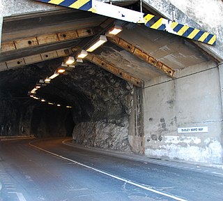
Dudley Ward Way is a road tunnel through the south-eastern part of the Rock of Gibraltar. It is named after Sir Alfred Dudley Ward, Governor of Gibraltar from 8 June 1962 to 5 August 1965. The road running through the tunnel links the eastern side of The Rock via Sir Herbert Miles Road, with Europa Point, at the southern tip of Gibraltar via Europa Advance Road.

Gibraltar is a British Overseas Territory and city located at the southern tip of the Iberian Peninsula, on the Bay of Gibraltar, near the exit of the Mediterranean Sea into the Atlantic Ocean. It has an area of 6.8 km2 (2.6 sq mi) and is bordered to the north by Spain. The landscape is dominated by the Rock of Gibraltar, at the foot of which is a densely populated town area, home to some 34,003 people, primarily Gibraltarians.

The military history of Gibraltar during World War II exemplifies Gibraltar's position as a British fortress from the early-18th century onwards and as a vital factor in British military strategy, both as a foothold on the continent of Europe, and as a bastion of British sea power. During World War II, Gibraltar served a vital role in both the Atlantic Theatre and the Mediterranean Theatre, controlling virtually all naval traffic moving between the Mediterranean Sea and the Atlantic Ocean.

Parson's Lodge Battery is a coastal battery and fort in the British Overseas Territory of Gibraltar.

Profield Contractors, also referred to as Profield Contractors Ltd, is a Gibraltar-based construction company founded in 1989. The company has worked on a number of general construction and civil engineering projects in Gibraltar.

Streets in the British Overseas Territory of Gibraltar are represented by road signs as in the United Kingdom. As of 2007, Gibraltar has a network of 29 kilometres (18 mi) of roads.
O'Hara's Battery is an artillery battery in the British Overseas Territory of Gibraltar. It is located at the highest point of the Rock of Gibraltar, near the southern end of the Upper Rock Nature Reserve, in close proximity to Lord Airey's Battery. It was constructed in 1890 at the former site of a watchtower that had earned the name O'Hara's Folly. The battery and tower were both named after the Governor of Gibraltar Charles O'Hara. The first gun mounted on the battery was a 6-inch breech loading gun, which was replaced with a 9.2 inch Mark X BL gun in 1901. The battery was in use during World War II and was last fired during training exercises in 1976. O'Hara's Battery has been refurbished and is open to the public. The battery and its associated works are listed with the Gibraltar Heritage Trust.

Lord Airey's Battery is an artillery battery in the British Overseas Territory of Gibraltar. It is located near the southern end of the Upper Rock Nature Reserve, just north of O'Hara's Battery. It was named after the Governor of Gibraltar, General Sir Richard Airey. Construction of the battery was completed in 1891. The first gun mounted on the battery was a 6-inch breech loading gun, which was replaced with a 9.2-inch Mark X BL gun by 1900. The gun at the battery was last fired in the 1970s. In 1997, it was discovered that Lord Airey's Shelter, adjacent to Lord Airey's Battery, was the site chosen for a covert World War II operation that entailed construction of a cave complex in the Rock of Gibraltar, to serve as an observation post. The battery is listed with the Gibraltar Heritage Trust.
Operation Tracer was a secret Second World War Royal Navy military operation in Gibraltar, a British Overseas Territory and military base. The impetus for the stay-behind plan was the 1940 scheme by Germany to capture Gibraltar, code-named Operation Felix. Operation Tracer was the brainchild of Rear Admiral John Henry Godfrey, the Director of the Naval Intelligence Division of the Admiralty.

Monkey's Cave is a cave in the British Overseas Territory of Gibraltar. It has been used as part of the Fortifications of Gibraltar and in 1942 there was a convalescent hospital here. This building was later used as the HQ of the Royal Electrical & Mechanical Engineers.
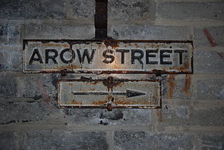
AROW Street is a tunnel in Gibraltar that was excavated in 1942. The tunnel, like Gibraltar's Great North Road, was large enough to take Army ammunition trucks.

The Gibraltar peninsula, located at the far southern end of Iberia, has great strategic importance as a result of its position by the Strait of Gibraltar where the Mediterranean Sea meets the Atlantic Ocean. It has repeatedly been contested between European and North African powers and has endured fourteen sieges since it was first settled in the 11th century. The peninsula's occupants – Moors, Spanish, and British – have built successive layers of fortifications and defences including walls, bastions, casemates, gun batteries, magazines, tunnels and galleries. At their peak in 1865, the fortifications housed around 681 guns mounted in 110 batteries and positions, guarding all land and sea approaches to Gibraltar. The fortifications continued to be in military use until as late as the 1970s and by the time tunnelling ceased in the late 1960s, over 34 miles (55 km) of galleries had been dug in an area of only 2.6 square miles (6.7 km2).

The Great North Road is a large road tunnel in the British Overseas Territory of Gibraltar. It was constructed by the British military during World War II inside the Rock of Gibraltar and remains property of the Ministry of Defence to this day. The road allowed lorries to travel from the north to the south of Gibraltar entirely within the Rock. The tunnel still contains the remains of World War II buildings such as Nissen huts, kitchens, offices as well as a generating station and period anti-submarine nets.

The tunnels of Gibraltar were constructed over the course of nearly 200 years, principally by the British Army. Within a land area of only 2.6 square miles (6.7 km2), Gibraltar has around 34 miles (55 km) of tunnels, nearly twice the length of its entire road network. The first tunnels, excavated in the late 18th century, served as communication passages between artillery positions and housed guns within embrasures cut into the North Face of the Rock. More tunnels were constructed in the 19th century to allow easier access to remote areas of Gibraltar and accommodate stores and reservoirs to deliver the water supply of Gibraltar.

