Gibraltar has a limited public transport system, due to the compact size of the territory.

Portsea Island is a flat and low-lying natural island 24.5 square kilometres in area, just off the southern coast of Hampshire in England. Portsea Island contains the majority of the city of Portsmouth.

The word dock in American English refers to one or a group of human-made structures that are involved in the handling of boats or ships. In British English, the term is not used the same way as in American English, it is used to mean the area of water that is next to or around a wharf or quay. The exact meaning varies among different variants of the English language.

The East Coast Parkway is an expressway that runs along the southeastern coast of Singapore. It is approximately 16 kilometres (9.9 mi) in length. As of July 2022, it is Singapore's third-longest expressway.

Saint Peter Port Harbour is located in Saint Peter Port, Guernsey. It was a natural anchorage used by the Romans which has been changed into an artificial harbour that is now the island's main port for passengers. Loose cargo, liquids and gas are shipped to and from St Sampson's harbour.

RFA Bedenham was a naval armament carrier of the British Royal Fleet Auxiliary that exploded while docked in Gibraltar on 27 April 1951, killing 13 people and causing a great deal of damage to the town.
Hodges Drive is a main west–east road in Joondalup, north of Perth, Western Australia. It begins in the suburb of Ocean Reef at a T-junction with Boat Habour Quays in the Ocean Reef Marina and runs through the residential areas in Ocean Reef, Connolly and Heathridge, before terminating at Joondalup Drive. The road continues from there as Grand Boulevard. Hodges Drive is a four lane dual-carriageway for its entire length apart from a small section near the interchange with Boat Habour Quays where it becomes a 2 lane road.

Bathurst Basin is a small triangular basin adjoining the main harbour of the city of Bristol, England. The basin takes its name from Charles Bathurst, who was a Bristol MP in the early 19th century.
State Highway 74 is a state highway in New Zealand servicing the eastern suburbs of Christchurch. Mostly two-lane, it is composed of limited-access expressways, with part of the highway as the Christchurch-Lyttelton Motorway, and connects the city to its port town of Lyttelton.

The Detached Mole is a breakwater located at the western aspect of the middle section of Gibraltar Harbour, in the British Overseas Territory of Gibraltar, at the southern end of the Iberian Peninsula. The Detached Mole, with the rest of harbour, is just north of the east entrance to the Strait of Gibraltar and was the site of the Detached Mole Battery. In addition to the role the breakwater plays in the defence of and access to the harbour, the Detached Mole provides berths for ships. The area adjacent to the mole is also a source of recreational and research opportunities, with dive sites at the wrecks of sunken ships.

The North Mole is a breakwater located in the northern section of Gibraltar Harbour, in the British Overseas Territory of Gibraltar, at the southern end of the Iberian Peninsula. The North Mole, with the rest of harbour, is just north of the east entrance to the Strait of Gibraltar. The breakwater was formerly known as the Commercial Mole, and is the site of the commercial port in the harbour. It was the consequence of a late nineteenth century plan by the British Admiralty to create a modern dockyard and large defensive harbour in Gibraltar.
Marina Bay is the largest of three marinas in the British Overseas Territory of Gibraltar, at the southern end of the Iberian Peninsula. It is located in the Bay of Gibraltar, between the North Mole of Gibraltar Harbour and the runway of Gibraltar International Airport. Marina Bay and the adjacent Ocean Village Marina together have been incorporated into the Ocean Village Project.

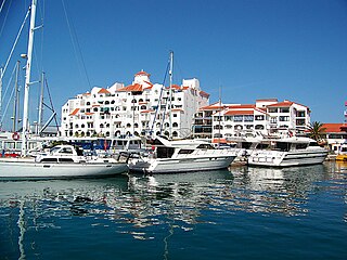
The Queensway Quay Marina is one of three marinas in the British Overseas Territory of Gibraltar, at the southern end of the Iberian Peninsula. The yachting facility is located at the eastern aspect of the middle section of Gibraltar Harbour. It is the site of what may be the oldest wharf in Gibraltar, Ragged Staff Wharf.

The Ocean Village Marina is one of three marinas in the British Overseas Territory of Gibraltar, at the southern end of the Iberian Peninsula. Formerly Sheppard's Marina, it is located in the Bay of Gibraltar, between the North Mole of Gibraltar Harbour and the runway of Gibraltar International Airport. Both Ocean Village Marina and the adjacent Marina Bay have been incorporated into the Ocean Village Project, a luxury resort.

Streets in the British Overseas Territory of Gibraltar are represented by road signs as in the United Kingdom. As of 2007, Gibraltar has a network of 29 kilometres (18 mi) of roads.

King's Chapel is a small chapel in the British Overseas Territory of Gibraltar. It is located at the southern end of Main Street and adjoins the Governor of Gibraltar's residence, The Convent. What nowadays is King's Chapel was the first purpose-built church to be constructed in Gibraltar. Originally part of a Franciscan friary, the chapel was built in the 1530s but was given to the Church of England by the British after the capture of Gibraltar in 1704. It was badly damaged in the late 18th century during the Great Siege of Gibraltar and in the explosion of an ammunition ship in Gibraltar harbour in 1951, but was restored on both occasions. From 1844 to 1990 it served as the principal church of the British Army in Gibraltar; since then it has been used by all three services of the British Armed Forces.
Ragged Staff Cave is a cave bordering the harbour in the British Overseas Territory of Gibraltar. The cave was converted into Ragged Staff Magazine in 1901.

Ragged Staff Gates are a set of city gates in the British Overseas Territory of Gibraltar. They are located between South Bastion and Ragged Staff Guard, opposite the Navy Boat Sheds.

Line Wall Road is a road in the British Overseas Territory of Gibraltar. It is one of the main roads leading into the city centre. It runs immediately east of the Line Wall Curtain in a north–south direction, connecting Smith Dorrien Avenue near Grand Casemates Square with the southern end of Main Street at Southport Gates. It runs parallel with Queensway through much of its length at an elevated level. Part of the western defensive wall has been excavated along Line Wall Road.


