
A roundabout, a rotary and a traffic circle are types of circular intersection or junction in which road traffic is permitted to flow in one direction around a central island, and priority is typically given to traffic already in the junction.

The M2 is a 26-mile-long (42 km) long motorway in Kent, England, and was built to bypass a section of the A2 road in Kent, which goes through the Medway Towns, Sittingbourne, and Faversham. It provides an alternative route to the Port of Dover, which supplements the M20 motorway located further to the south. The terminal junctions of the M2 intersect with the A2, which come together to form a 62-mile-long (100 km) long trunk road from London to Dover.

The A4 is a major road in England from Central London to Avonmouth via Heathrow Airport, Reading, Bath and Bristol. It is historically known as the Bath Road with newer sections including the Great West Road and Portway. The road was once the main route from London to Bath, Bristol and the west of England and formed, after the A40, the second main western artery from London.

The A46 is a major A road in England. It starts east of Bath, Somerset and ends in Cleethorpes, Lincolnshire, but it does not form a continuous route. Large portions of the old road have been lost, bypassed, or replaced by motorway development. Between Leicester and Lincoln the road follows the course of the Roman Fosse Way, but between Bath and Leicester, two cities also linked by the Fosse Way, it follows a more westerly course.
The A45 is a major road in England. It runs east from Birmingham past the National Exhibition Centre and the M42, then bypasses Coventry and Rugby, where it briefly merges with the M45 until it continues to Daventry. It then heads to Northampton and Wellingborough before running north of Rushden and Higham Ferrers and terminating at its junction with the A14 in Thrapston.

U.S. Route 42 is an east–west United States highway that runs southwest–northeast for 350 miles (560 km) from Louisville, Kentucky to Cleveland, Ohio. The route has several names including Pearl Road from Cleveland to Medina in Northeast Ohio, Reading Road in Cincinnati, Cincinnati and Lebanon Pike in southwestern Ohio and Brownsboro Road in Louisville. Traveling northeast, the highway ends in downtown Cleveland and traveling southwest ends in Louisville.
New York State Route 279 (NY 279) is a north–south state highway in Orleans County, New York, in the United States. The southern terminus of the route is at an intersection with NY 98 north of the village of Albion in the town of Gaines. Its northern terminus is at a junction with NY 18 in Carlton near where NY 18 meets the western end of the Lake Ontario State Parkway. The entirety of NY 279 north of NY 104 is maintained by Orleans County; south of NY 104, the route is maintained by the New York State Department of Transportation. NY 279 is a rural connector highway that serves only one community, the hamlet of Waterport on the banks of Oak Orchard Creek in Carlton.
The A5117 is a road in Cheshire, England. It runs between Shotwick (53.2374°N 2.9875°W) and Helsby (53.2613°N 2.7814°W) and connects the A550 at Woodbank to the M56. As such it forms a northerly bypass to Chester and a shorter route between the North West and North Wales than the A55.

The A160 is a short road in North Lincolnshire, England. It connects the A180 to Immingham docks. It is a dual carriageway for part of its length through the village of South Killingholme. Plans have been approved to entirely dual the road, and work started in spring 2015.
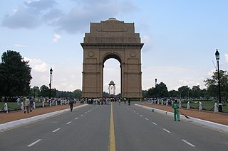
Akbar Road is a main road, in central New Delhi, India. At the north-east end it stretches from the India Gate roundabout. At the south-west end it stretches up to the Teen Murti roundabout. The roundabout leads to Lok Kalyan Marg, Rajaji Marg, Teen Murti Marg and Safdarjung Road. It is also the road on which India's political party, Indian National Congress, has its head office.

K-150 is a 16.645-mile (26.788 km) east–west state highway in the U.S. state of Kansas. The route begins at a roundabout with U.S. Route 56 (US-56) and US-77 northeast of Marion and runs east to a junction with US-50 southwest of Elmdale. It runs through the Flint Hills region of Kansas, and is a two-lane road its entire length. There are no cities or towns along the road, but it provides a direct link for traffic from Marion, Hillsboro, McPherson and points west to Emporia and the Kansas Turnpike.
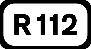
The R112 road is a regional road in south Dublin, Ireland. It begins at the junction with the R148 road at Chapelizod and arcs southeastwards, then eastwards across the middle of south Dublin, ending at the Mount Merrion junction of the R138. The road is a single-carriageway, with cycle lanes on some stretches. Improvements to the road have been made over the last 10 years, the most significant being at Dundrum Cross where the road was widened to make room for the new Luas bridge and Dundrum bypass.

Louisiana Highway 89 (LA 89) is a state highway located in southern Louisiana. It runs 12.74 miles (20.50 km) in a north–south direction from LA 14 in Delcambre to an intersection with Church Street in Youngsville.
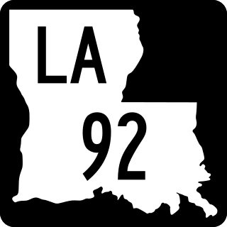
Louisiana Highway 92 (LA 92) is a state highway located in southern Louisiana. It runs 40.72 miles (65.53 km) in an east–west direction from U.S. Highway 90 (US 90) east of Mermentau to LA 339 in Youngsville.

Streets in the British Overseas Territory of Gibraltar are represented by road signs as in the United Kingdom. As of 2007, Gibraltar has a network of 29 kilometres (18 mi) of roads.
Devil's Tower Road is a road in the British Overseas Territory of Gibraltar. The road, in the northeastern part of the settlement, runs south of Gibraltar International Airport, from Winston Churchill Avenue southeast to Eastern Beach Road. It was named after Devil's Tower, a seventeenth-century watchtower that was formerly at the eastern end of the road. By 2011, Devil's Tower Road had been changed to a dual carriageway, with on-street parking eliminated, and the Government's plan to change the name of the road to North Front Avenue met with community opposition. A new access road was planned, such that Winston Churchill Avenue, which crosses the airport runway, would no longer serve as the main road to the Gibraltar-Spain border to intersect with Devil's Tower Road after passing under the eastern edge of the runway. The new road and tunnel, named Kingsway with the approval of Charles III, was officially opened on 31st March 2023.
Queensway is a main coastal road in the British Overseas Territory of Gibraltar and the only road servicing the oldest leisure marina on The Rock, Queensway Quay. It connects the marina with the industrial park in the southern end of the Gibraltar Harbour.

A650 road is a main route through the West Yorkshire conurbation in England. The road goes from Keighley to Wakefield on a rough north west/south east axis for 25 miles (40 km). The route is mostly single carriageway with some dualled sections in the Aire Valley, Bradford and the approach to Wakefield from the M1.
