Related Research Articles
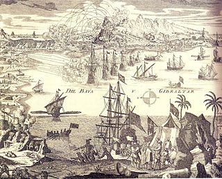
The siege of Gibraltar of 1727 saw Spanish forces besiege the British garrison of Gibraltar as part of the Anglo-Spanish War. Depending on the sources, Spanish troops numbered between 12,000 and 25,000. British defenders were 1,500 at the beginning of the siege, increasing up to about 5,000. After a five-month siege with several unsuccessful and costly assaults, Spanish troops gave up and withdrew. Following the failure the war drew to a close, opening the way for the 1728 Treaty of El Pardo and the Treaty of Seville signed in 1729.
The Gibraltar North Mole Elbow Lighthouse is one of several lighthouses in Gibraltar, a British Overseas Territory at the south end of the peninsula of Iberia. Also known as the Gibraltar "E" Head Lighthouse, its tower is painted grey. The active lighthouse is west of the Rock of Gibraltar and positioned at the elbow of the North Mole at Gibraltar Harbour. The lighthouse is operated by the Gibraltar Port Authority.

The South Mole is a breakwater located in the southern section of Gibraltar Harbour, in the British Overseas Territory of Gibraltar, at the southern end of the Iberian Peninsula. Previously known as the New Mole and New Mole Extension, the South Mole, with the rest of harbour, is just north of the east entrance to the Strait of Gibraltar.

The Detached Mole is a breakwater located at the western aspect of the middle section of Gibraltar Harbour, in the British Overseas Territory of Gibraltar, at the southern end of the Iberian Peninsula. The Detached Mole, with the rest of harbour, is just north of the east entrance to the Strait of Gibraltar and was the site of the Detached Mole Battery. In addition to the role the breakwater plays in the defence of and access to the harbour, the Detached Mole provides berths for ships. The area adjacent to the mole is also a source of recreational and research opportunities, with dive sites at the wrecks of sunken ships.

The North Mole is a breakwater located in the northern section of Gibraltar Harbour, in the British Overseas Territory of Gibraltar, at the southern end of the Iberian Peninsula. The North Mole, with the rest of harbour, is just north of the east entrance to the Strait of Gibraltar. The breakwater was formerly known as the Commercial Mole, and is the site of the commercial port in the harbour. It was the consequence of a late nineteenth century plan by the British Admiralty to create a modern dockyard and large defensive harbour in Gibraltar.

Rosia Bay is the only natural harbour in Gibraltar, the British Overseas Territory at the southern end of the Iberian Peninsula. Formerly referred to as Rosia Harbour, it is located on the southwest side of Gibraltar. Rosia Bay was the site of the Royal Navy Victualling Yard complex which was constructed in the early 19th century, allowing vessels to anchor and obtain provisions, including food and water. Vice Admiral Horatio Nelson obtained supplies for his Mediterranean Fleet at Rosia Bay. It was to that same anchorage that his vessel HMS Victory was towed after Nelson's death in the 1805 Battle of Trafalgar. The area is also the location of gun batteries, including Parson's Lodge Battery at the south end of the bay and Napier of Magdala Battery at the north end. In the 21st century, Rosia Bay was the focus of controversy following the government's demolition of the historic Rosia Water Tanks and construction of the affordable housing development Nelson's View, which necessitated the relocation of the owners of the adjacent 19th century Rosia Cottages.
The Line Wall Curtain is a defensive curtain wall that forms part of the fortifications of the British Overseas Territory of Gibraltar.

The Victualling Yard was a victualling facility in the British Overseas Territory of Gibraltar built for supplying Royal Navy ships while anchored at Rosia Bay.
Devil's Gap Battery is a coastal battery in the British Overseas Territory of Gibraltar, overlooking the Bay of Gibraltar near the westernmost limits of the Upper Rock Nature Reserve.
O'Hara's Battery is an artillery battery in the British Overseas Territory of Gibraltar. It is located at the highest point of the Rock of Gibraltar, near the southern end of the Upper Rock Nature Reserve, in close proximity to Lord Airey's Battery. It was constructed in 1890 at the former site of a watchtower that had earned the name O'Hara's Folly. The battery and tower were both named after the Governor of Gibraltar Charles O'Hara. The first gun mounted on the battery was a 6-inch breech loading gun, which was replaced with a 9.2 inch Mark X BL gun in 1901. The battery was in use during World War II and was last fired during training exercises in 1976. O'Hara's Battery has been refurbished and is open to the public. The battery and its associated works are listed with the Gibraltar Heritage Trust.

The North Bastion, formerly the Baluarte San Pablo was part of the fortifications of Gibraltar, in the north of the peninsula, protecting the town against attack from the mainland of Spain. The bastion was based on the older Giralda tower, built in 1309. The bastion, with a mole that extended into the Bay of Gibraltar to the west and a curtain wall stretching to the Rock of Gibraltar on its east, was a key element in the defenses of the peninsula. After the British took Gibraltar in 1704 they further strengthened these fortifications, flooding the land in front and turning the curtain wall into the Grand Battery.

Middle Hill Battery is an artillery battery in the British Overseas Territory of Gibraltar. It is located on Middle Hill, at the northeastern end of the Upper Rock Nature Reserve, just south of Green's Lodge Battery and Rock Gun Battery. The emplacement dates to 1727, when a single gun was mounted. By the turn of the twentieth century, six 10-inch rifled muzzle-loading guns were present at Middle Hill Battery. Other buildings documented at that time as part of the battery complex included the Nursery Hut and the Middle Hill Group, the latter a cluster of buildings which perched on the cliff edge. An anti-aircraft Bofors gun had been installed at the battery by the Second World War. After the war, the area transitioned to use as a Ministry of Defence aerial farm. In 2005, the battery and surrounding area were transferred to the Government of Gibraltar. The site is now managed by the Gibraltar Ornithological and Natural History Society.

Devil's Tongue Battery was an artillery battery in the British Overseas Territory of Gibraltar. The battery could overlook the harbour but the remains are now surrounded by reclaimed land.

Alexandra Battery is a coastal artillery battery in the British Overseas Territory of Gibraltar. It was constructed at the neck of the South Mole to enfilade the coastal fortifications of Gibraltar. The battery stood on the site of several previous fortifications; it was built over the New Mole Battery, which was itself constructed on the site of an old Spanish fort in front of the Tuerto Tower.
Cumberland Flank Battery was an artillery battery in the British Overseas Territory of Gibraltar.

The Gibraltar peninsula, located at the far southern end of Iberia, has great strategic importance as a result of its position by the Strait of Gibraltar where the Mediterranean Sea meets the Atlantic Ocean. It has repeatedly been contested between European and North African powers and has endured fourteen sieges since it was first settled in the 11th century. The peninsula's occupants – Moors, Spanish, and British – have built successive layers of fortifications and defences including walls, bastions, casemates, gun batteries, magazines, tunnels and galleries. At their peak in 1865, the fortifications housed around 681 guns mounted in 110 batteries and positions, guarding all land and sea approaches to Gibraltar. The fortifications continued to be in military use until as late as the 1970s and by the time tunnelling ceased in the late 1960s, over 34 miles (55 km) of galleries had been dug in an area of only 2.6 square miles (6.7 km2).

The King's Lines are a walled rock-cut trench on the lower slopes of the north-west face of the Rock of Gibraltar. Forming part of the Northern Defences of the fortifications of Gibraltar, they were originally created some time during the periods when Gibraltar was under the control of the Moors or Spanish. They are depicted in a 1627 map by Don Luis Bravo de Acuña, which shows their parapet following a tenaille trace. The lines seem to have been altered subsequently, as maps from the start of the 18th century show a more erratic course leading from the Landport, Gibraltar's main land entrance, to the Round Tower, a fortification at their western end. A 1704 map by Johannes Kip calls the Lines the "Communication Line of the Round Tower".

The Prince of Wales Lines were a set of earthworks constructed in Gibraltar in 1756 on the orders of Lord Tyrawley, during his term as Governor of Gibraltar. They consisted of a series of retrenchments for guns and muskets constructed between the glacis of the South Front to the New Mole, south of Gibraltar's urban area.
The North Mole Elbow Battery was an artillery battery situated on Gibraltar's Old Mole, at the point where the mole turns north. It is recorded as mounting three 12-pdr guns in 1903. It mounted a Bofors 40 mm anti-aircraft gun during the Second World War along with a 6-pdr gun on a twin mounting for coastal defence purposes. At the end of the mole, another 6-pdr gun was installed on a twin mounting.
References
- 1 2 Fa, Darren; Finlayson, Clive (2006). The Fortifications of Gibraltar 1068-1945. Osprey Publishing. p. 57. ISBN 978-1-84603-016-1 . Retrieved 4 April 2013.
| | This article about a building or structure in Gibraltar is a stub. You can help Wikipedia by expanding it. |