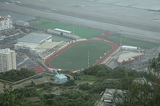
Victoria Stadium is a multi-purpose stadium in Gibraltar. It is currently used mostly for football matches, but also hosts the annual Gibraltar Music Festival. It is located close to Gibraltar Airport just off Winston Churchill Avenue. It was named after the wife of Gibraltarian philanthropist John Mackintosh.
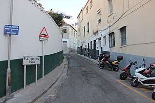
Flat Bastion Road is a road in Gibraltar, the British Overseas Territory at the southern end of the Iberian Peninsula. The road runs north–south, providing views of the city and Bay of Gibraltar. Previously known in Spanish as Senda del Moro, the traditional Llanito name for the road is Cuesta de Mr. Bourne.
RM Bickleigh, or Bickleigh Barracks, is a military installation at Bickleigh, South Hams which is currently used by 42 Commando.

Nun's Well is an ancient underground water reservoir in the British Overseas Territory of Gibraltar. It is located at Europa Point, and is thought to be of the Moorish period. It represents some of the earliest evidence of an artificial water supply in Gibraltar. The name of the cistern is thought to be derived from the nuns associated with the Shrine of Our Lady of Europe. In the eighteenth century, Nun's Well supplied the military with water. In the early nineteenth century, it provided water for the brewery that was built next door. In 1988, the Royal Engineers constructed what is now the main building, which has a castle-like appearance. Nun's Well became the focus of controversy during the 2010-2011 restoration of the site.

The Charles V Wall is a 16th-century defensive curtain wall that forms part of the fortifications of the British Overseas Territory of Gibraltar. Originally called Muralla de San Benito, it was built in 1540 and strengthened in 1552 by Holy Roman Emperor Charles V. The wall remains largely intact and extends from South Bastion, which was once at the water's edge in the harbour, to the top ridge of the Rock of Gibraltar.

The North Bastion, formerly the Baluarte San Pablo was part of the fortifications of Gibraltar, in the north of the peninsula, protecting the town against attack from the mainland of Spain. The bastion was based on the older Giralda tower, built in 1309. The bastion, with a mole that extended into the Bay of Gibraltar to the west and a curtain wall stretching to the Rock of Gibraltar on its east, was a key element in the defenses of the peninsula. After the British took Gibraltar in 1704 they further strengthened these fortifications, flooding the land in front and turning the curtain wall into the Grand Battery.

King's Bastion is a coastal bastion on the western front of the fortifications of the British overseas territory of Gibraltar, protruding from the Line Wall Curtain. It is located between Line Wall Road and Queensway and overlooks the Bay of Gibraltar. It played a crucial role in defending The Rock during the Great Siege of Gibraltar. In more recent history the bastion was converted into a generating station which powered Gibraltar's electricity needs. Today it continues to serve the community as Gibraltar's leisure centre.

Jumper's Bastion may refer to one of two adjacent bastions in the British Overseas Territory of Gibraltar. They were both created in 1785 on the sites of previous constructions and named for a British Captain who was one on the first on shore during the Capture of Gibraltar in 1704.

Buena Vista Battery was an artillery battery near the Buena Vista Barracks at the southern end of the British Overseas Territory of Gibraltar. It is located on a slight ridge in front of the nearby Buena Vista Barracks, which was once the base of the Royal Gibraltar Regiment.
Woodford's Battery was an artillery battery in the British Overseas Territory of Gibraltar. It is located at Europa Flats between the Defensible Barracks and the Officer's Barracks and Eliott's Battery.
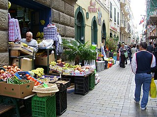
Irish Town is a pedestrianised street in the British Overseas Territory of Gibraltar. It is one of Main Street's sub-districts running parallel to it, from Cooperage Lane in the north to John Mackintosh Square in the south.

Town Range is a major road in the British Overseas Territory of Gibraltar. It is located in the old town area and runs parallel to Main Street and part of Prince Edward's Road. It is also known in Spanish as Calle Cuartel, in reference to the barracks constructed on the street in 1740. It is one of the three main parallel streets in the old town and is likely to date back to the Moorish period. Until the mid-19th century it was notorious for its filthiness due to wholly inadequate sanitation and lack of any running water supply. It was the point of outbreak of Gibraltar's devastating 1804 epidemic of yellow fever, which killed a third of the territory's population. The street is now a residential and commercial area notable for several important public buildings in addition to the old Georgian barracks, which have been converted for civilian use.

Lathbury Barracks was a military barracks in the British Overseas Territory of Gibraltar that is currently used by civilians. It is located in the southern part of the Rock, south of Spur Battery on Windmill Hill. The last United Kingdom regiment based here was the 3rd Battalion Royal Green Jackets who handed it over to the local Royal Gibraltar Regiment and it is now owned by the Government of Gibraltar.

The Gibraltar peninsula, located at the far southern end of Iberia, has great strategic importance as a result of its position by the Strait of Gibraltar where the Mediterranean Sea meets the Atlantic Ocean. It has repeatedly been contested between European and North African powers and has endured fourteen sieges since it was first settled in the 11th century. The peninsula's occupants – Moors, Spanish, and British – have built successive layers of fortifications and defences including walls, bastions, casemates, gun batteries, magazines, tunnels and galleries. At their peak in 1865, the fortifications housed around 681 guns mounted in 110 batteries and positions, guarding all land and sea approaches to Gibraltar. The fortifications continued to be in military use until as late as the 1970s and by the time tunnelling ceased in the late 1960s, over 34 miles (55 km) of galleries had been dug in an area of only 2.6 square miles (6.7 km2).
The Windmill Hill Batteries are a series of artillery batteries situated on Windmill Hill, Gibraltar near the south of the peninsula. They are part of the fortifications of Gibraltar. The batteries were originally established by Lt General Edward Cornwallis during his governorship of Gibraltar between 1762–77, built on the site of the old windmills after which the hill was named. The singular Windmill Hill Battery refers to one particular battery almost equidistant between Genista Battery and Europa Advance Battery.

The Prince's Lines are part of the fortifications of Gibraltar, situated on the lower slopes of the north-west face of the Rock of Gibraltar. They are located at a height of about 70 feet (21 m) on a natural ledge above the Queen's Lines, overlooking the landward entrance to Gibraltar, and run from a natural fault called the Orillon to a cliff at the southern end of the isthmus linking Gibraltar with Spain. The lines face out across the modern Laguna Estate, which stands on the site of the Inundation, an artificial lake created to obstruct landward access to Gibraltar. They were constructed to enfilade attackers approaching Gibraltar's Landport Front from the landward direction.

Windmill Hill or Windmill Hill Flats is one of a pair of plateaux, known collectively as the Southern Plateaux, at the southern end of the British Overseas Territory of Gibraltar. It is located just to the south of the Rock of Gibraltar, which descends steeply to the plateau. Windmill Hill slopes down gently to the south with a height varying from 120 metres (390 ft) at the north end to 90 metres (300 ft) at the south end. It covers an area of about 19 hectares, though about 6 hectares at the north end is built over. The plateau is ringed to the south and east with a line of cliffs which descend to the second of the Southern Plateaux, Europa Flats, which is itself ringed by sea cliffs. Both plateaux are the product of marine erosion during the Quaternary period and subsequent tectonic uplift. Windmill Hill was originally on the shoreline and its cliffs were cut by the action of waves, before the ground was uplifted and the shoreline moved further out to the edge of what is now Europa Flats.
The Defensible Barracks is a fortified barracks located at Europa Flats in the British Overseas Territory of Gibraltar.
The Retrenched Barracks was a fortified barracks located at Windmill Hill in the British Overseas Territory of Gibraltar. It stands to the north of the southern tip of Gibraltar, Europa Point, which was long felt to be potentially vulnerable to a surprise attack from the sea and was heavily fortified with gun batteries, perimeter walls and scarped cliffs.
The University of Gibraltar is a degree-awarding higher education institution established by the Government of Gibraltar through the University of Gibraltar Act 2015. The founding of the university was described by Gibraltar's Chief Minister Fabian Picardo as "a coming-of-age" for the British Overseas Territory.

