Fort Wool is a decommissioned island fortification located in the mouth of Hampton Roads, adjacent to the Hampton Roads Bridge-Tunnel (HRBT). Officially known as Rip Raps Island, the fort has an elevation of 7 feet and sits near Old Point Comfort, Old Point Comfort Light, Willoughby Beach and Willoughby Spit, approximately one mile south of Fort Monroe.

Shornemead Fort is a now-disused artillery fort that was built in the 1860s to guard the entrance to the Thames from seaborne attack. Constructed during a period of tension with France, it stands on the south bank of the river at a point where the Thames curves sharply north and west, giving the fort long views up and downriver in both directions. It was the third fort constructed on the site since the 18th century, but its location on marshy ground led to major problems with subsidence. The fort was equipped for a time with a variety of large-calibre artillery guns which were intended to support two other nearby Thamesside forts. However, the extent of the subsidence meant that it became unsafe for the guns to be fired and the fort was disarmed by the early 20th century.
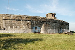
Coalhouse Fort is an artillery fort in the eastern English county of Essex. It was built in the 1860s to guard the lower Thames from seaborne attack. It stands at Coalhouse Point on the north bank of the river, at a location near East Tilbury which was vulnerable to raiders and invaders. It was the last in a series of fortifications dating back to the 15th century and was the direct successor to a smaller mid-19th century fort built on the same site. Constructed during a period of tension with France, its location on marshy ground caused problems from the start and led to a lengthy construction process. The fort was equipped with a variety of large-calibre artillery guns and the most modern defensive facilities of the time, including shell-proof casemates protected by granite facing and cast-iron shields. Its lengthy construction and the rapid pace of artillery development at the time meant that it was practically obsolete for its original purpose within a few years of its completion.

Beacon Hill Battery is a late-19th and 20th century coastal fortification that was built to defend the port of Harwich, Essex. It is a scheduled ancient monument.

A casemate is a fortified gun emplacement or armored structure from which guns are fired, in a fortification, warship, or armoured fighting vehicle.

Fort Pasir Panjang or Labrador Battery is located within Labrador Park at the southern tip of Singapore island. It was one of the 11 coastal artillery forts built by the British in the 19th century to defend the western passageway into Keppel Harbour against piracy and foreign naval powers. During the 1942 Battle of Pasir Panjang, the fort played a supporting role but a limited one in defending the Malay Regiments against the Japanese invasion at Bukit Chandu. In 1995, the site was gazetted by the National Heritage Board as one of the 11 World War II sites in Singapore.
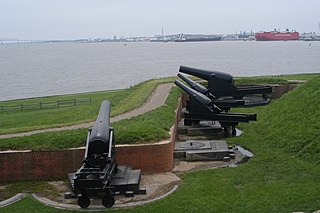
Seacoast defense was a major concern for the United States from its independence until World War II. Before airplanes, many of America's enemies could only reach it from the sea, making coastal forts an economical alternative to standing armies or a large navy. After the 1940s, it was recognized that fixed fortifications were obsolete and ineffective against aircraft and missiles. However, in prior eras foreign fleets were a realistic threat, and substantial fortifications were built at key locations, especially protecting major harbors.

Parson's Lodge Battery is a coastal battery and fort in the British Overseas Territory of Gibraltar.

The North Bastion, formerly the Baluarte San Pablo was part of the fortifications of Gibraltar, in the north of the peninsula, protecting the town against attack from the mainland of Spain. The bastion was based on the older Giralda tower, built in 1309. The bastion, with a mole that extended into the Bay of Gibraltar to the west and a curtain wall stretching to the Rock of Gibraltar on its east, was a key element in the defenses of the peninsula. After the British took Gibraltar in 1704 they further strengthened these fortifications, flooding the land in front and turning the curtain wall into the Grand Battery.

Breakneck Battery is an artillery battery in the British Overseas Territory of Gibraltar. It is located on Ministry of Defence property at the Upper Rock Nature Reserve, north of Lord Airey's Battery. It is one of a dozen batteries in Gibraltar that had 9.2-inch (233.7 mm) guns installed around the turn of the twentieth century. The emplacement features a 9.2-inch Mark X breech-loading gun on a Mark V mounting. The battery was refurbished by 10 Signal Regiment in 2012 and 2016 whilst being on Ceremonial duties whilst the Gibraltar Regiment where on exercise and is one of three surviving 9.2-inch gun emplacements at the Upper Ridge of the Rock of Gibraltar. By the late twentieth century, the 9.2-inch guns in Gibraltar, Bermuda, Portugal, South Africa, and Australia were the remaining examples of an emplacement that at one point had been mounted at strategic locations across the British Empire.

The Orange Bastion is one of the many bastions in the British Overseas Territory of Gibraltar, which served to protect it against its many sieges. It is located along the Line Wall Curtain and was built to protect Gibraltar Harbour against enemy attack.

King's Bastion is a coastal bastion on the western front of the fortifications of the British overseas territory of Gibraltar, protruding from the Line Wall Curtain. It is located between Line Wall Road and Queensway and overlooks the Bay of Gibraltar. It played a crucial role in defending The Rock during the Great Siege of Gibraltar. In more recent history the bastion was converted into a generating station which powered Gibraltar's electricity needs. Today it continues to serve the community as Gibraltar's leisure centre.

Wellington Front is a fortification in the British Overseas Territory of Gibraltar. It was built in 1840 on a site established by the Spanish in 1618.

Jumper's Bastion may refer to one of two adjacent bastions in the British Overseas Territory of Gibraltar. They were both created in 1785 on the sites of previous constructions and named for a British Captain who was one on the first on shore during the Capture of Gibraltar in 1704.

Farringdon's Battery is an artillery battery in the British Overseas Territory of Gibraltar. Named after Sir Anthony Farrington, 1st Baronet, it is located above the north face of the Rock of Gibraltar within the Upper Rock Nature Reserve.

Buena Vista Battery was an artillery battery near the Buena Vista Barracks at the southern end of the British Overseas Territory of Gibraltar. It is located on a slight ridge in front of the nearby Buena Vista Barracks, which was once the base of the Royal Gibraltar Regiment.

Zoca Flank Battery is an artillery battery on the west side of the British Overseas Territory of Gibraltar.
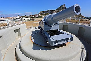
Harding's Battery is a restored artillery battery in the British Overseas Territory of Gibraltar. It is located at Europa Point and includes the Europa Sunken Magazine that is now used as a visitor centre.

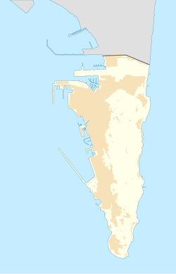
The Gibraltar peninsula, located at the far southern end of Iberia, has great strategic importance as a result of its position by the Strait of Gibraltar where the Mediterranean Sea meets the Atlantic Ocean. It has repeatedly been contested between European and North African powers and has endured fourteen sieges since it was first settled in the 11th century. The peninsula's occupants – Moors, Spanish, and British – have built successive layers of fortifications and defences including walls, bastions, casemates, gun batteries, magazines, tunnels and galleries. At their peak in 1865, the fortifications housed around 681 guns mounted in 110 batteries and positions, guarding all land and sea approaches to Gibraltar. The fortifications continued to be in military use until as late as the 1970s and by the time tunnelling ceased in the late 1960s, over 34 miles (55 km) of galleries had been dug in an area of only 2.6 square miles (6.7 km2).
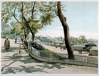
Victoria Battery was an artillery battery in the British Overseas Territory of Gibraltar. It was built in the 1840s on top of the earlier Princess of Wales Batteries following a report by Major-General Sir John Thomas Jones on Gibraltar's defences. The battery was located on the west side of Gibraltar and was one of a number of "retired" batteries in the territory, constructed to improve the coastal defences between Europa Point and the town.

