Related Research Articles

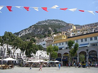
Gibraltar is a British Overseas Territory and city located at the southern tip of the Iberian Peninsula, on the Bay of Gibraltar, near the exit of the Mediterranean Sea into the Atlantic Ocean. It has an area of 6.8 km2 (2.6 sq mi) and is bordered to the north by Spain. The landscape is dominated by the Rock of Gibraltar, at the foot of which is a densely populated town area, home to some 34,003 people, primarily Gibraltarians.

The Trafalgar Cemetery is a cemetery in the British Overseas Territory of Gibraltar. Formerly known as the Southport Ditch Cemetery, it occupies a small area of land just to the south of the city walls, in what had been a defensive ditch during the period of Spanish rule of Gibraltar. Although it is named for the Battle of Trafalgar of 21 October 1805, only two victims of the battle are buried there. The remainder of the interments are mostly of those killed in other sea battles or casualties of the yellow fever epidemics that swept Gibraltar between 1804 and 1814. In addition, tombstones were transferred to the Trafalgar Cemetery from St. Jago's Cemetery and Alameda Gardens.

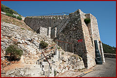
Flat Bastion is a bastion which projects southward from the Charles V Wall in the British Overseas Territory of Gibraltar. Once known as the St. Jago's Bastion or the Baluarte de Santiago in Spanish, the fortification was built by the Spanish in the mid 16th century and formed part of the southern defences of the city of Gibraltar, together with Charles V Wall, Southport Gates, Southport Ditch, and South Bastion. In 1859, six guns, four 12-pounders and two 12-pound carronades, were installed on the bastion, and four years later, five 32-pounders were mounted on the fortification.
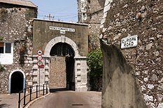
Prince Edward's Gate is a city gate at the entrance to Prince Edward's Road in the British Overseas Territory of Gibraltar. It cuts through Charles V Wall, one of the 16th century fortifications of Gibraltar at the former southern limit of the city. The gate is adjacent to the west wall of the Flat Bastion, another 16th-century fortification. The gate was named after Prince Edward, the future Duke of Kent, and was opened in 1790, the same year the prince arrived at Gibraltar as commander of the 7th Regiment of Foot. While the gate now has a limited role in the defence of Gibraltar, it continues to provide vehicular and pedestrian access through Charles V Wall. Prince Edward's Gate is listed with the Gibraltar Heritage Trust.

The Southport Gates are three city gates in the British Overseas Territory of Gibraltar. They are located in the Charles V Wall, one of the 16th century fortifications of Gibraltar. The gates are clustered together, with the South Bastion to the west, and the Trafalgar Cemetery to the east. The first and second Southport Gates were constructed at present day Trafalgar Road in 1552 and 1883, respectively. The third gate, Referendum Gate, is the widest of the three and was constructed in 1967 at Main Street, immediately west of the first two gates. The Southport Gates are listed with the Gibraltar Heritage Trust.

The Charles V Wall is a 16th-century defensive curtain wall that forms part of the fortifications of the British Overseas Territory of Gibraltar. Originally called Muralla de San Benito, it was built in 1540 and strengthened in 1552 by Holy Roman Emperor Charles V. The wall remains largely intact and extends from South Bastion, which was once at the water's edge in the harbour, to the top ridge of the Rock of Gibraltar.

Grand Casemates Gates, formerly Waterport Gate, provide an entrance from the northwest to the old, fortified portion of the city of the British Overseas Territory of Gibraltar, at Grand Casemates Square.

The history of Moorish Gibraltar began with the landing of the Muslims in Hispania and the fall of the Visigothic Kingdom of Toledo in 711 and ended with the fall of Gibraltar to Christian hands 751 years later, in 1462, with an interregnum during the early 14th century.
Grand Casemates Square is the larger of the two main squares within the city centre of Gibraltar. The square takes its name from the British-built Grand Casemates, a casemate and bombproof barracks at the northern end of the square completed in 1817.

Levant Battery is an artillery battery in the British Overseas Territory of Gibraltar. It is located on Windmill Hill, at the southern end of the Upper Rock Nature Reserve, below observation post Fire Control South. It was named after the Levanter cloud, below which it perched, giving it an unobstructed view. Construction started in 1901 and, by 1903, a 9.2-inch Mark X breech-loading gun had been mounted. The battery was decommissioned in the 1970s and the gun was later removed, to rest in a scrap yard. A community group has been formed to garner support for the gun's recovery and restoration.
The seventh siege of Gibraltar (1436) was an unsuccessful attempt by the Castillian nobleman Enrique Pérez de Guzmán, 2nd Count de Niebla to capture the stronghold of Gibraltar from the Moors. He drowned during the attempt.
The eighth siege of Gibraltar (1462) was a successful effort by soldiers of the Kingdom of Castile to take the fortified town of Gibraltar from the Moors of the Emirate of Granada. Capture of this position, which was weakly defended and was taken with little fighting, was strategically important in the final defeat of the Moors in Spain.

King's Lines Battery is an artillery battery in the British Overseas Territory of Gibraltar. It was originally built along the access path up to the Gate of Granada.

Prince Ferdinand's Battery was an artillery battery in the British Overseas Territory of Gibraltar. Today the area is known as the Apes' Den and is the main location for tourists to see Barbary macaques in Gibraltar.

Granada Gate was a city gate in the British Overseas Territory of Gibraltar. It was the main entry point by land to the old town of Gibraltar.
Queen's Gate is a city gate in the British Overseas Territory of Gibraltar. A large population of Barbary macaques reside in this area, making it a major tourist attraction. Most of the macaques sleep within an area of 9 hectares around the Queen's Gate.

Ragged Staff Gates are a set of city gates in the British Overseas Territory of Gibraltar. They are located between South Bastion and Ragged Staff Guard, opposite the Navy Boat Sheds.

Castle Batteries are a series of artillery batteries that are part of the Northern Defences of the British Overseas Territory of Gibraltar. The batteries descend from the Moorish Castle to end at the sixth and seven batteries which are known as Crutchett's Batteries. There are brick vaulted bombproof rooms (casemates) under Crutchets Battery.

The 2015 Navarrese regional election was held on Sunday, 24 May 2015, to elect the 9th Parliament of the Chartered Community of Navarre. All 50 seats in the Parliament were up for election. The election was held simultaneously with regional elections in twelve other autonomous communities and local elections all throughout Spain.

The Gibraltar peninsula, located at the far southern end of Iberia, has great strategic importance as a result of its position by the Strait of Gibraltar where the Mediterranean Sea meets the Atlantic Ocean. It has repeatedly been contested between European and North African powers and has endured fourteen sieges since it was first settled in the 11th century. The peninsula's occupants – Moors, Spanish, and British – have built successive layers of fortifications and defences including walls, bastions, casemates, gun batteries, magazines, tunnels and galleries. At their peak in 1865, the fortifications housed around 681 guns mounted in 110 batteries and positions, guarding all land and sea approaches to Gibraltar. The fortifications continued to be in military use until as late as the 1970s and by the time tunnelling ceased in the late 1960s, over 34 miles (55 km) of galleries had been dug in an area of only 2.6 square miles (6.7 km2).
References
- ↑ Fa & Finlayson (2006). The Fortifications of Gibraltar 1068-1945. Osprey Publishing. p. 12. ISBN 978-1-84603-016-1 . Retrieved 1 April 2013.
- ↑ Mann, J H. (1870). A history of Gilbralter and its sieges. Lib. ed. Provost. p. 205 . Retrieved 1 April 2013.
| | This article about a building or structure in Gibraltar is a stub. You can help Wikipedia by expanding it. |