Related Research Articles

The British post offices in Morocco, also known as the "Morocco Agencies", were a system of post offices operated by Gibraltar and later the United Kingdom in Morocco.

Gibraltar is a British Overseas Territory located at the southern tip of the Iberian Peninsula. It has an area of 6.7 km2 (2.6 sq mi) and is bordered to the north by Spain. The landscape is dominated by the Rock of Gibraltar, at the foot of which is a densely populated town area, home to over 32,000 people, primarily Gibraltarians.

The Trafalgar Cemetery is a cemetery in the British Overseas Territory of Gibraltar. Formerly known as the Southport Ditch Cemetery, it occupies a small area of land just to the south of the city walls, in what had been a defensive ditch during the period of Spanish rule of Gibraltar. Although it is named for the Battle of Trafalgar of 21 October 1805, only two victims of the battle are buried there. The remainder of the interments are mostly of those killed in other sea battles or casualties of the yellow fever epidemics that swept Gibraltar between 1804 and 1814. In addition, tombstones were transferred to the Trafalgar Cemetery from St. Jago's Cemetery and Alameda Gardens.

A Royal Naval Hospital (RNH) was a hospital operated by the British Royal Navy for the care and treatment of sick and injured naval personnel. A network of these establishments were situated across the globe to suit British interests. They were part of the Royal Naval Medical Service.

The Gibraltar Methodist Church is part of the South East District of the Methodist Church of Great Britain. It has a long history associated with the development of British Gibraltar, and it has greatly strengthened its ties with the local population since the scaling down of Britain-based forces in recent years. In 2006 it appointed Fidel Patron - the first Gibraltarian Superintendent Minister.

Education in Gibraltar generally follows the English system operating within a three tier system. Schools in Gibraltar follow the Key Stage system which teaches the National Curriculum.
King George V Hospital was a psychiatric hospital in the British Overseas Territory of Gibraltar run by the Gibraltar Health Authority. The hospital was established before 1799. The mental health facility underwent renovation in 2012. In 1799, the King George V Psychiatric Unit had beds for 63 patients.

Bristol Hotel is Gibraltar's oldest hotel. It is located on Cathedral Square in Gibraltar, next to the Church of England Cathedral. Established in 1894 the 19th century, it occupies a white colonial building with swimming pool and garden, located to the south of Cathedral of St. Mary the Crowned, next to the Gibraltar Museum. The hotel has 60 rooms and includes a subtropical garden.
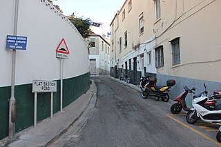
Flat Bastion Road is a road in Gibraltar, the British Overseas Territory at the southern end of the Iberian Peninsula. The road runs north–south, providing views of the city and Bay of Gibraltar. Previously known in Spanish as Senda del Moro, the traditional Llanito name for the road is Cuesta de Mr. Bourne.

Flat Bastion is a bastion which projects southward from the Charles V Wall in the British Overseas Territory of Gibraltar. Once known as the St. Jago's Bastion or the Baluarte de Santiago in Spanish, the fortification was built by the Spanish in the mid 16th century and formed part of the southern defences of the city of Gibraltar, together with Charles V Wall, Southport Gates, Southport Ditch, and South Bastion. In 1859, six guns, four 12-pounders and two 12-pound carronades, were installed on the bastion, and four years later, five 32-pounders were mounted on the fortification.
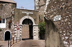
Prince Edward's Gate is a city gate at the entrance to Prince Edward's Road in the British Overseas Territory of Gibraltar. It cuts through Charles V Wall, one of the 16th century fortifications of Gibraltar at the former southern limit of the city. The gate is adjacent to the west wall of the Flat Bastion, another 16th-century fortification. The gate was named after Prince Edward, the future Duke of Kent, and was opened in 1790, the same year the prince arrived at Gibraltar as commander of the 7th Regiment of Foot. While the gate now has a limited role in the defence of Gibraltar, it continues to provide vehicular and pedestrian access through Charles V Wall. Prince Edward's Gate is listed with the Gibraltar Heritage Trust.

The Flat Bastion Magazine is a 19th-century magazine in the British Overseas Territory of Gibraltar. It is located within the Flat Bastion, a fortification that projects from the 16th century Charles V Wall at the former southern limit of the city. Flat Bastion Road extends through the bastion, just to the west of the magazine, south of which it becomes Gardiner's Road. Flat Bastion Magazine was constructed to store gunpowder, but eventually lay abandoned for years. While the Government of Gibraltar initially planned to develop it for parking, geology enthusiast Freddie Gomez and a colleague restored the building, which is now used as a geological research facility and exhibition centre. Both the Flat Bastion and the Flat Bastion Magazine are listed with the Gibraltar Heritage Trust. In addition, Gomez received the 2001 Heritage Award for the restoration of the building.
An orillon, also known as an orillion, is an architectural element of a military fortification. The ear-shaped projection of masonry provided defense for guns and soldiers at the flank of a bastion. However, an orillon could also shield a city gate.

The Southport Gates are three city gates in the British Overseas Territory of Gibraltar. They are located in the Charles V Wall, one of the 16th century fortifications of Gibraltar. The gates are clustered together, with the South Bastion to the west, and the Trafalgar Cemetery to the east. The first and second Southport Gates were constructed at present day Trafalgar Road in 1552 and 1883, respectively. The third gate, Referendum Gate, is the widest of the three and was constructed in 1967 at Main Street, immediately west of the first two gates. The Southport Gates are listed with the Gibraltar Heritage Trust.

Streets in the British Overseas Territory of Gibraltar are represented by road signs as in the United Kingdom. As of 2007, Gibraltar has a network of 29 kilometres (18 mi) of roads.

The North Bastion, formerly the Baluarte San Pablo was part of the fortifications of Gibraltar, in the north of the peninsula, protecting the town against attack from the mainland of Spain. The bastion was based on the older Giralda tower, built in 1309. The bastion, with a mole that extended into the Bay of Gibraltar to the west and a curtain wall stretching to the Rock of Gibraltar on its east, was a key element in the defenses of the peninsula. After the British took Gibraltar in 1704 they further strengthened these fortifications, flooding the land in front and turning the curtain wall into the Grand Battery.

Town Range is a major road in the British Overseas Territory of Gibraltar. It is located in the old town area and runs parallel to Main Street and part of Prince Edward's Road. It is also known in Spanish as Calle Cuartel, in reference to the barracks constructed on the street in 1740. It is one of the three main parallel streets in the old town and is likely to date back to the Moorish period. Until the mid-19th century it was notorious for its filthiness due to wholly inadequate sanitation and lack of any running water supply. It was the point of outbreak of Gibraltar's devastating 1804 epidemic of yellow fever, which killed a third of the territory's population. The street is now a residential and commercial area notable for several important public buildings in addition to the old Georgian barracks, which have been converted for civilian use.
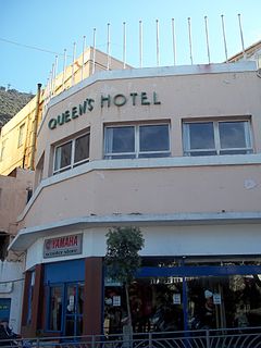
The Queen's Hotel was a family run hotel in the British Overseas Territory of Gibraltar, located on 1 Boyd Street, between Trafalgar Cemetery and the Gibraltar Botanic Gardens. The hotel was established in 1954. It described itself as "Gibraltar's only budget hotel".
It was located near the Alameda Botanical Gardens and Gibraltar’s cable car both less than 100 metres away. The hotel had 62 rooms some with balcony and featured a restaurant with panoramic views across the bay. It offered a spacious bar and lounge area featuring wooden beamed ceilings and traditional brick archways.
It closed in June 2014 after being bought out by the Gibraltar Government to make way for the new Theatre Complex, which will include the Queen's Cinema.
The Christian Brothers School was a school in the British Overseas Territory of Gibraltar. The school was a technical school in the 1930s and in 1950 became the Gibraltar Grammar School until comprehensive education was introduced in the 1970s. The building was then home to Sacred Heart Middle School but was no longer run by the Congregation of Christian Brothers. In July 2015, Sacred Heart Middle School became St Bernards Middle School and moved to a different location. The building was renovated and now houses Prior Park School, Gibraltar's first co-educational, Christian-Catholic Independent Secondary School. Prior Park School is the fourth school in the Prior Park family, the other three being located in Bath and Wiltshire, UK.

Malta Dockyard was an important naval base in the Grand Harbour in Malta in the Mediterranean Sea. The infrastructure which is still in operation is now exploited by Palumbo Shipyards.
References
- ↑ Great Britain. Foreign and Commonwealth Office (1969). Gibraltar. H.M. Stationery Office. p. 31. Retrieved 17 July 2012.
- ↑ Kramer, Dr. Johannes (1986). English and Spanish in Gibraltar. Buske Verlag. p. 32. ISBN 978-3-87118-815-2 . Retrieved 20 October 2013.
- ↑ Great Britain. Board of Education (1905). Special reports on educational subjects. H. M. Stationery Office. p. 462. Retrieved 17 July 2012.
This article relating to a school in Gibraltar is a stub. You can help Wikipedia by expanding it. |