
Sea Hill Lighthouse, also known as Sea Hill Point Light or Little Sea Hill Light, is a lighthouse on the northwest point of Curtis Island, Gladstone Region, Queensland, Australia. Its purpose was to mark the east side of the entrance to Keppel Bay, on passage to Fitzroy River and Port Alma. The first lighthouse at the locations was constructed in 1873 or 1876, moved in the 1920s, and is now on display at the Gladstone Maritime Museum. A second lighthouse was constructed in 1895 and its state is unclear.

Point Cartwright Light is an active lighthouse located on Point Cartwright, a point near the mouth of the Mooloolah River, in Mooloolaba, Queensland, Australia. It marks the entrance to the North West Channel, a deep water channel into Moreton Bay and the Port of Brisbane, and provides guidance into the Mooloolaba Harbour.

The Europa Point Lighthouse, also referred to as the Trinity Lighthouse at Europa Point and the Victoria Tower or La Farola in Llanito, is a lighthouse at Europa Point, on the southeastern tip of the British Overseas Territory of Gibraltar, on the southern end of the Iberian Peninsula, at the entrance to the Mediterranean Sea.

The Gibraltar North Mole Lighthouse is one of several lighthouses in Gibraltar, the British Overseas Territory at the southern end of the Iberian Peninsula. Also referred to as the Gibraltar "D" Head Lighthouse, its cast-iron tower is painted black. The active lighthouse west of the Rock of Gibraltar is positioned on the Western Arm of the North Mole at Gibraltar Harbour, and is operated by the Gibraltar Port Authority.

The Gibraltar South Mole Lighthouse is one of several lighthouses in Gibraltar, a British Overseas Territory at the south end of the Iberian Peninsula. Also known as the Gibraltar "A" Head Lighthouse, it has a cast-iron, skeletal tower which is painted black and features two galleries. The lighthouse remains operational and is positioned west of the Rock of Gibraltar, on the South Mole at Gibraltar Harbour. It is operated by the Gibraltar Port Authority.
The Gibraltar Aerobeacon built in 1841 is one of several lighthouses in Gibraltar, the British Overseas Territory at the southern end of the Iberian Peninsula. It is also known as the Gibraltar Aviation Light and Gibraltar Aero Light. The active beacon is positioned atop the Rock of Gibraltar and is operated by the Government of Gibraltar.

The South Mole is a breakwater located in the southern section of Gibraltar Harbour, in the British Overseas Territory of Gibraltar, at the southern end of the Iberian Peninsula. Previously known as the New Mole and New Mole Extension, the South Mole, with the rest of harbour, is just north of the east entrance to the Strait of Gibraltar.
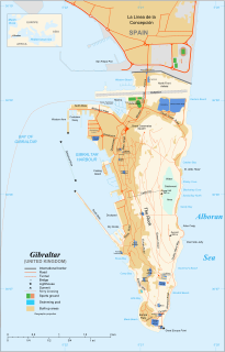
The Detached Mole is a breakwater located at the western aspect of the middle section of Gibraltar Harbour, in the British Overseas Territory of Gibraltar, at the southern end of the Iberian Peninsula. The Detached Mole, with the rest of harbour, is just north of the east entrance to the Strait of Gibraltar and was the site of the Detached Mole Battery. In addition to the role the breakwater plays in the defence of and access to the harbour, the Detached Mole provides berths for ships. The area adjacent to the mole is also a source of recreational and research opportunities, with dive sites at the wrecks of sunken ships.
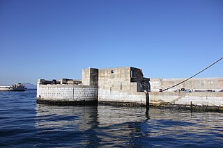
The Gibraltar Detached Mole Lighthouse is one of several lighthouses in Gibraltar, a British Overseas Territory at the south end of the Iberian Peninsula. The lighthouse is positioned west of the Rock of Gibraltar, on the Detached Mole at the south entrance to Gibraltar Harbour.
The Gibraltar Detached Mole Lighthouse is one of several lighthouses in Gibraltar, a British Overseas Territory at the south end of the Iberian Peninsula. The lighthouse is positioned west of the Rock of Gibraltar, on the Detached Mole at the north entrance to Gibraltar Harbour.

The North Mole is a breakwater located in the northern section of Gibraltar Harbour, in the British Overseas Territory of Gibraltar, at the southern end of the Iberian Peninsula. The North Mole, with the rest of harbour, is just north of the east entrance to the Strait of Gibraltar. The breakwater was formerly known as the Commercial Mole, and is the site of the commercial port in the harbour. It was the consequence of a late nineteenth century plan by the British Admiralty to create a modern dockyard and large defensive harbour in Gibraltar.

The North Bull Lighthouse, is an active aid to navigation located at the mouth of the River Liffey, near Dublin, Ireland. It is one of four lighthouses that help guide shipping into the Liffey, and the Port of Dublin, all of which are operated and maintained by the Dublin Port Company.

The Arenas Blancas Lighthouse is an active lighthouse on the Canary island of La Palma in the municipality of Villa de Mazo, near the village of La Salemera. The larger settlement of Mazo lies 8 km (5.0 mi) to the north-west.
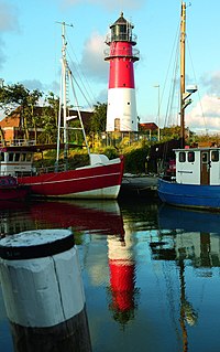
Büsum Lighthouse is an active 20th century lighthouse located in Büsum a fishing and tourist town, which lies on North Sea coast of Schleswig-Holstein, in Germany. The current lighthouse is the second to be built in the town, two other separate breakwater lights mark the entrance of the small harbour from the North Sea.
