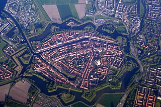
Brielle, also called Den Briel in Dutch and Brill in English, is a town and historic seaport in the western Netherlands, in the province of South Holland, on the north side of the island of Voorne-Putten, at the mouth of the New Maas. The former municipality covered an area of 31.14 km2 (12.02 sq mi) of which 3.59 km2 (1.39 sq mi) was water. In 2021 its population was 17,439.

Hellevoetsluis is a small city in the western Netherlands. It is located in Voorne-Putten, South Holland. The former municipality covered an area of 61.20 km2 (23.63 sq mi) of which 20.10 km2 (7.76 sq mi) was water and it included the population centres of Nieuw-Helvoet, Nieuwenhoorn, and Oude en Nieuwe Struiten, all former municipalities.

Roker is a tourist resort and affluent area of Sunderland, North East England, bounded on the south by the River Wear and Monkwearmouth, on the east by the North Sea, to the west by Fulwell and on the north by Seaburn. It is administered as part of the City of Sunderland and lies within historic County Durham.
The Sands Point Lighthouse is located in the Incorporated Village of Sands Point in the Town of North Hempstead, in Nassau County, on the North Shore of Long Island, in New York, United States. The fourth lighthouse to be established on Long Island, this 1809 stone tower was built by an American Revolutionary War veteran who stayed on as its first keeper for many years. The Lighthouse is sometimes referred to the Mitchell Lighthouse, after Samuel L. Mitchell, the man who fought for it to be constructed.

The Macquarie Lighthouse, also known as South Head Upper Light, is the first, and is the longest serving, lighthouse site in Australia. It is located on Dunbar Head, on Old South Head Road, Vaucluse in the Municipality of Woollahra local government area of New South Wales, Australia. The lighthouse is situated approximately 2 kilometres (1 mi) south of South Head near the entrance to Sydney Harbour. There has been a navigational aid in this vicinity since 1791 and a lighthouse near the present site since 1818. The current heritage-listed lighthouse was completed in 1883. The lighthouse and associated buildings were designed by James Barnet and built from 1881 to 1883.
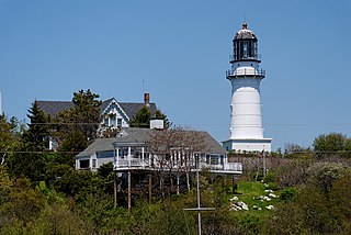
Cape Elizabeth Light is a lighthouse in Cape Elizabeth, at the southwestern entrance to Casco Bay in Maine.

The Cascumpeque Light is a deactivated lighthouse on the western north coast of Prince Edward Island, Canada. The station was established in 1856 and the lighthouse itself was built in 1899.

Söderarm is the name of a deactivated Swedish lighthouse station and its surrounding small archipelago in the west part of the Sea of Åland.

The Low Lighthouse is one of three historic lighthouses in Burnham-on-Sea, Somerset, England, and the only one of the three which is still active. It is a Grade II listed building and stands on the foreshore. First lit in 1832, the Low Lighthouse operated in conjunction with the (onshore) High Lighthouse for 137 years. Then, in 1969 the Low Lighthouse was deactivated; but later, in 1993, the Low Lighthouse was re-established and the High Lighthouse was instead decommissioned).

Maasvlakte Light is an inactive lighthouse in Maasvlakte, an industrial area in the city of Rotterdam, the Netherlands. At a height of 216 feet (66 m) it is the twelfth-tallest "traditional lighthouse" in the world, as well as the second-tallest concrete lighthouse in the world, and the tallest Dutch lighthouse.
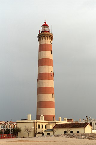
The Lighthouse of Praia da Barra, also known as the Aveiro Lighthouse, is an active lighthouse in the civil parish of Gafanha da Nazaré, municipality of Ílhavo, in the Portuguese district of Aveiro. Situated on the coastal Praia da Barra, at the southern margin of the Ria de Aveiro, it is the tallest lighthouse in Portugal, with a height of 203 feet (62 m) overseeing the barrier beach and exposed to Atlantic storms. It is open to the public and visits are held on Wednesdays from 14:00 to 17:00.
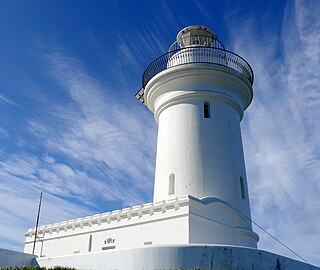
South Solitary Island Light is an active lighthouse on South Solitary Island, an island within the Solitary Islands Marine Park, about 15 kilometres (9.3 mi) northeast of Coffs Harbour, New South Wales, Australia. The lighthouse is located at the summit of the island. It is considered the most isolated lighthouse on the New South Wales coast. It was first in New South Wales to use kerosene over colza oil, and the last to do so before converting to electric power.
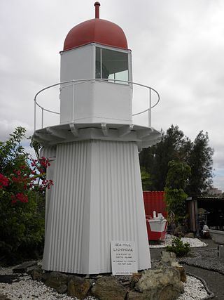
Sea Hill Lighthouse, also known as Sea Hill Point Light or Little Sea Hill Light, is a lighthouse on the northwest point of Curtis Island, Gladstone Region, Queensland, Australia. Its purpose was to mark the east side of the entrance to Keppel Bay, on passage to Fitzroy River and Port Alma. The first lighthouse at the locations was constructed in 1873 or 1876, moved in the 1920s, and is now on display at the Gladstone Maritime Museum. A second lighthouse was constructed in 1895 and its state is unclear.

The J.C.J. van Speijk Lighthouse is a lighthouse on the North Sea coast near Egmond aan Zee, in the municipality of Bergen, North Holland, in the Netherlands. The foundation of the lighthouse, shaped like a tomb, is the official Dutch memorial to Jan van Speyk, a hero to the Dutch people.

Kollam Beach, also known as Mahatma Gandhi Beach, is a beach at Kollam city in the Indian state of Kerala. Kollam Beach is the first 'Beach Wedding Destination' in Kerala.

The South Mole is a breakwater located in the southern section of Gibraltar Harbour, in the British Overseas Territory of Gibraltar, at the southern end of the Iberian Peninsula. Previously known as the New Mole and New Mole Extension, the South Mole, with the rest of harbour, is just north of the east entrance to the Strait of Gibraltar.

Plover Scar Lighthouse, also known as the Abbey Lighthouse, is an active 19th century lighthouse sited at the entrance of the Lune estuary, near Cockersand Abbey in Lancashire, England. The lighthouse is maintained by the Lancaster Port Commission. It is registered under the international Admiralty number A4876 and has the NGA identifier of 114-5144.

Murano Lighthouse is an active lighthouse located in the south east part of the island of Murano in the Venetian Lagoon on the Adriatic Sea.

The Vuurbaak van Katwijk aan Zee is a Dutch lighthouse in Katwijk aan Zee, in South Holland, on the North Sea. It is the second oldest lighthouse in the country; only the Brandaris (1594) is older. The lighthouse was essentially just a 12-metre-tall (39 ft) tower on top of which a fire was lit whenever Katwijker fishers were out at sea. The fire was replaced with an oil lamp in the mid-19th century; by the early 1900s there were no fishing vessels from Katwijk and the lighthouse became inactive.

Saint John's Point or St. John's Point is a cape at the southern tip of the Lecale peninsula of County Down, Northern Ireland, separating Dundrum Bay from Killough Harbour, which forms its northern extremity. The cape is mostly surrounded by the Irish Sea and derives its name from a now ruined church dedicated to Saint John, being recorded here since at least 1170. A well-known beacon in the north-eastern Irish Sea, St. John's Point Lighthouse, built in 1844, sits near its southern tip and, at 40 m (130 ft), is the tallest lighthouse in Ireland.

