
The Meuse or Maas is a major European river, rising in France and flowing through Belgium and the Netherlands before draining into the North Sea from the Rhine–Meuse–Scheldt delta. It has a total length of 925 km.
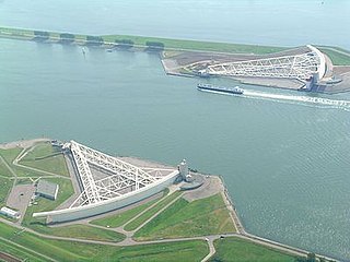
The Nieuwe Waterweg is a ship canal in the Netherlands from het Scheur west of the town of Maassluis to the North Sea at Hook of Holland: the Maasmond, where the Nieuwe Waterweg connects to the Maasgeul. It is the artificial mouth of the river Rhine.

The Rhine is one of the major European rivers. The river begins in the Swiss canton of Graubünden in the southeastern Swiss Alps. It forms the Swiss-Liechtenstein border and partly the Swiss-Austrian and Swiss-German borders. After that the Rhine defines much of the Franco-German border, after which it flows in a mostly northerly direction through the German Rhineland. Finally in Germany, the Rhine turns into a predominantly westerly direction and flows into the Netherlands where it eventually empties into the North Sea. It drains an area of 9,973 km2.
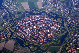
Brielle, also called Den Briel in Dutch and Brill in English, is a town and historic seaport in the western Netherlands, in the province of South Holland, on the north side of the island of Voorne-Putten, at the mouth of the New Maas. The former municipality covered an area of 31.14 km2 (12.02 sq mi) of which 3.59 km2 (1.39 sq mi) was water. In 2021 its population was 17,439.

Rozenburg is a town and former municipality in the western Netherlands, in the province of South Holland. The municipality had a population of 13,173 in 2004, and covers an area of 6.50 km2. It was the second-smallest municipality in the Netherlands in area. On 10 July 2008, the local council decided to disband the municipality and to form a submunicipality of Rotterdam. This was ratified on 27 October 2008 by the Eerste Kamer, and came into effect on 18 March 2010.

The Scheur is a branch of the Rhine-Meuse delta in South Holland, Netherlands, that flows west from the confluence of the Oude Maas and Nieuwe Maas branches past the towns of Rozenburg and Maassluis. It continues as the Nieuwe Waterweg to the North Sea.

The Botlek originally was the name of a stretch of the Nieuwe Maas river, part of the Rhine–Meuse delta near the Dutch cities of Vlaardingen and Spijkenisse in the province of South Holland. Specifically, it was the name of the strait that separated the island of Rozenburg from the sand bar of Welplaat. The strait itself was merely the continuation of the Nieuwe Maas, and the stretch of the river south of Rozenburg continued to be called Nieuwe Maas until the confluence with Het Scheur formed the Brielse Maas estuary.

Lower Rhine refers to the section of the Rhine between Bonn in Germany and the North Sea at Hook of Holland in the Netherlands, including the Nederrijn within the Rhine–Meuse–Scheldt delta; alternatively, Lower Rhine may also refer to just the part upstream of Pannerdens Kop, excluding the Nederrijn.

The Port of Rotterdam is the largest seaport in Europe, and the world's largest seaport outside of East Asia, located in and near the city of Rotterdam, in the province of South Holland in the Netherlands. From 1962 until 2004, it was the world's busiest port by annual cargo tonnage. It was overtaken first in 2004 by the port of Singapore, and since then by Shanghai and other very large Chinese seaports. In 2020, Rotterdam was the world's tenth-largest container port in terms of twenty-foot equivalent units (TEU) handled. In 2017, Rotterdam was also the world's tenth-largest cargo port in terms of annual cargo tonnage.
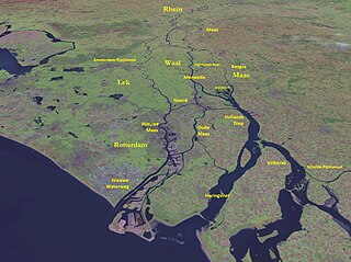
The Merwede is the name of several connected stretches of river in the Netherlands, between the cities of Woudrichem, Dordrecht and Papendrecht. The river is part of the Rhine–Meuse–Scheldt delta and is mostly fed by the river Rhine.

The Battle of Zwartewaal was a decisive naval battle during the Hook and Cod wars.

The Rhine–Meuse–Scheldt delta is a river delta in the Netherlands formed by the confluence of the Rhine, the Meuse and the Scheldt rivers. In some cases, the Scheldt delta is considered a separate delta to the Rhine–Meuse delta. The result is a multitude of islands, branches and branch names, in which a waterway that appears to be one continuous stream may have numerous separate names for different sections, e.g. Rhine → Bijlands Kanaal → Pannerdens Kanaal → Nederrijn → Lek → Nieuwe Maas → Het Scheur → Nieuwe Waterweg. Since the Rhine contributes most of the water, the term "Rhine Delta" is commonly used, although this name is also used for the delta where the Alpine Rhine flows into Lake Constance. By some calculations, the Rhine–Meuse–Scheldt delta covers 25,347 km2 (9,787 sq mi), making it the largest in Europe.

The Oude Maas is a distributary of the river Rhine, and a former distributary of the river Maas, in the Dutch province of South Holland. It begins at the city of Dordrecht where the Beneden Merwede river splits into the Noord and the Oude Maas. It ends when it joins the Nieuwe Maas to form Het Scheur.

The Nieuwe Maas is a distributary of the Rhine River, and a former distributary of the Maas River, in the Dutch province of South Holland. It runs from the confluence of the rivers Noord and Lek, and flows west through Rotterdam. It ends west of the city where it meets the Oude Maas, near Vlaardingen, to form Het Scheur. After a few miles, the Scheur continues as the artificial Nieuwe Waterweg. The total length of the Nieuwe Maas is approximately 24 kilometres (15 mi).

Rozenburg is an island in western Netherlands, in the province of South Holland. Rozenburg Island was formed centuries ago from several sand bars in the Meuse estuary. In 1568, construction started on the first set of dikes and in 1586 the land known as Roosenburgh was leased to Dirk Ariensz. Bisdommer and Son, the first permanent inhabitant of Rozenburg.

The Voorne Canal is a former ship canal on Voorne-Putten in South Holland, the Netherlands. It was the first canal to connect Rotterdam to the sea. Construction of the canal started in 1826 and was completed in 1829. Until the completion of the Nieuwe Waterweg in 1872 it was the main connection from Rotterdam to the sea for ocean going ships.
The Brielse Maas is a dammed river branch between the North Sea and the Oude Maas in the southern part of the Dutch province of South Holland. The town of Brielle, which gave it its name, is located on the south bank. Originally the Brielse Maas was part of the Nieuwe Maas: at the Vondelingenplaat the Oude Maas and the Nieuwe Maas came together and split into the Brielse Maas and the Scheur. The Brielse Maas was the main shipping channel and mouth of the Rijn-Maas delta.

The Drongelens Canal is a drainage canal that runs from 's-Hertogenbosch to Drongelen in North Brabant. The colloquial Dutch name, and the name used on street signs is Drongelens Kanaal. The official Dutch name is Afwateringskanaal van 's-Hertogenbosch naar Drongelen.

SS De Batavier, launched in 1827 was an early steamship which served on the Rotterdam to London line of the Nederlandsche Stoomboot Maatschappij (NSM). As such she was in news quite often, but the Batavier also appeared in fiction and non-fiction. The Batavier is the location of a chapter of Thackeray's Vanity Fair.


