The Meuse or Maas is a major European river, rising in France and flowing through Belgium and the Netherlands before draining into the North Sea from the Rhine–Meuse–Scheldt delta. It has a total length of 925 km.

The Rhine is one of the major European rivers. The river begins in the Swiss canton of Graubünden in the southeastern Swiss Alps. It forms part of the Swiss-Liechtenstein, Swiss-Austrian, Swiss-German borders. After that the Rhine defines much of the Franco-German border, after which it flows in a mostly northerly direction through the German Rhineland. Finally in Germany the Rhine turns into a predominantly westerly direction and flows into the Netherlands where it eventually empties into the North Sea. It drains an area of 9,973 sq km and its name derives from the Celtic Rēnos. There are also two German states named after the river, North Rhine-Westphalia and Rhineland-Palatinate.
The Delta Works is a series of construction projects in the southwest of the Netherlands to protect a large area of land around the Rhine–Meuse–Scheldt delta from the sea. Constructed between 1954 and 1997, the works consist of dams, sluices, locks, dykes, levees, and storm surge barriers located in the provinces of South Holland and Zeeland.

Hellevoetsluis is a small city in the western Netherlands. It is located in Voorne-Putten, South Holland. The former municipality covered an area of 61.20 km2 (23.63 sq mi) of which 20.10 km2 (7.76 sq mi) was water and it included the population centres of Nieuw-Helvoet, Nieuwenhoorn, and Oude en Nieuwe Struiten, all former municipalities.

Goeree-Overflakkee is the southernmost delta island of the province of South Holland, Netherlands. It is separated from Voorne-Putten and Hoeksche Waard by the Haringvliet, from the mainland of North Brabant by the Volkerak, and from Schouwen-Duiveland by Lake Grevelingen.

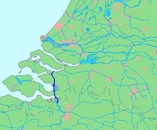
The Spui is a small tidal river in South Holland in the Netherlands, connecting the river Oude Maas and the Haringvliet estuary, separating the islands of Voorne-Putten and Hoeksche Waard. Historically, it forked off the Oude Maas at the town of Oud-Beijerland to end in the Haringvliet, but as a (planned) result from the Delta Works, its flow has been reversed. The Spui emerged as a result of a levee breach during the All Saints' Flood of 1532, a storm surge that permanently altered the surrounding landscape.

Hollands Diep is a wide river in the Netherlands and an estuary of the Rhine and Meuse rivers. Through the Scheldt-Rhine Canal it connects to the Scheldt river and Antwerp.

The Afgedamde Maas is a former distributary of the Maas River in the Dutch provinces of North Brabant and Gelderland. The Maas splits near Heusden with one channel flowing north until its confluence with the river Waal to form the Merwede, while the other channel continues west as the main distributary of the Maas.
The Nieuwe Merwede is a Dutch canal, mainly fed by the river Rhine, that was constructed in 1870 to form a branch in the Rhine–Meuse delta. It was dug along the general trajectories of a number of minor Biesbosch creeks to reduce the risk of flooding by diverting the water away from the Beneden Merwede, and to facilitate navigation and regulate river traffic in the increasingly silted-up delta.
The Scheldt–Rhine Canal (Schelde-Rijnkanaal) in Belgium and the Netherlands connects Antwerp with the Volkerak, and thereby the Scheldt with the Rhine.

Grevelingen or Grevelingenmeer is a closed off part of the Rhine-Meuse estuary on the border of the Dutch provinces of South Holland and Zeeland.

Europoort is an area of the Port of Rotterdam and the adjoining industrial area in the Netherlands. Being situated at Southside of the mouth of the rivers Rhine and Meuse with the hinterland consisting of the Netherlands, Germany, Belgium and partly France, Europoort is one of the world's busiest ports and considered a major entry to Europe. The port handled 12 million containers in 2015.

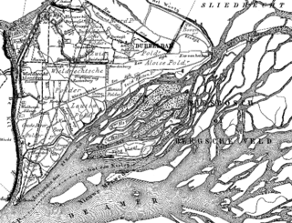
De Biesbosch National Park is one of the largest national parks of the Netherlands and one of the last extensive areas of freshwater tidal wetlands in Northwestern Europe. The Biesbosch consists of a large network of rivers and smaller and larger creeks with islands. The vegetation is mostly willow forests, although wet grasslands and fields of reed are common as well. The Biesbosch is an important wetland area for waterfowl and has a rich flora and fauna. It is especially important for migrating geese.
The Merwede etymology uncertain, possibly derived from the ancient Dutch Merwe or Merowe, a word meaning "wide water") is the name of several connected stretches of river in the Netherlands, between the cities of Woudrichem, Dordrecht and Papendrecht. The river is part of the Rhine–Meuse–Scheldt delta and is mostly fed by the river Rhine.
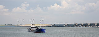
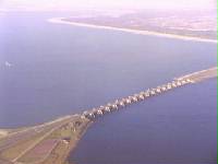
The Haringvliet sluices are a construction that closed off the estuary of the Haringvliet, Netherlands, as part of the Delta Works. The structure consists of 17 sluices, several kilometres of dam and a shipping lock.

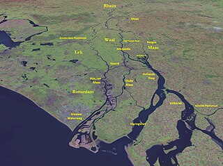
The Rhine–Meuse–Scheldt delta is a river delta in the Netherlands formed by the confluence of the Rhine, the Meuse and the Scheldt rivers. In some cases, the Scheldt delta is considered a separate delta to the Rhine–Meuse delta. The result is a multitude of islands, branches and branch names that may at first sight look bewildering, especially as a waterway that appears to be one continuous stream may change names as many as seven times, e.g. Rhine → Bijlands Kanaal → Pannerdens Kanaal → Nederrijn → Lek → Nieuwe Maas → Het Scheur → Nieuwe Waterweg. Since the Rhine contributes most of the water, the shorter term Rhine Delta is commonly used. However, this name is also used for the delta where the Alpine Rhine flows into Lake Constance, so it is clearer to call the larger one Rhine–Meuse delta, or even Rhine–Meuse–Scheldt delta, as the Scheldt ends in the same delta. By some calculations, the delta covers 25,347 km2 (9,787 sq mi), making it the largest in Europe.

The Oude Maas is a distributary of the river Rhine, and a former distributary of the river Maas, in the Dutch province of South Holland. It begins at the city of Dordrecht where the Beneden Merwede river splits into the Noord and the Oude Maas. It ends when it joins the Nieuwe Maas to form Het Scheur.

The Voorne Canal is a former ship canal on Voorne-Putten in South Holland, the Netherlands. It was the first canal to connect Rotterdam to the sea. Construction of the canal started in 1826 and was completed in 1829. Until the completion of the Nieuwe Waterweg in 1872 it was the main connection from Rotterdam to the sea for ocean going ships.

The Volkerakdam or Volkerakwerken is the name given to a group of hydraulic engineering structures located between Goeree-Overflakkee and North Brabant in The Netherlands. The works are not a single dam, but are composed of three distinct structures: a dam between Goeree-Overflakkee and Hellegatsplein, a series of locks from Hellegatsplein to North Brabant, and a bridge from Hellegatsplein to Hoekse Waard. The works cross three separate bodies of water: the Haringvliet, Hollands Diep and Volkerak. The works together comprise the fifth project of the Delta Works.

The Grevelingendam is a dam located in the Grevelingen sea inlet between Schouwen-Duiveland and Goeree-Overflakkee in The Netherlands. The Grevelingendam was the fourth structure constructed as part of the Delta Works.