Vecht (Utrecht)

Last updated
Satellite image of the surroundings of Utrecht showing river Vecht (c) and the Amsterdam-Rhine Canal (g). RhineUtrecht.jpg
Satellite image of the surroundings of Utrecht showing river Vecht (c) and the Amsterdam-Rhine Canal (g).
Location of river Vecht (in dark blue). Location vecht.jpg
Location of river Vecht (in dark blue).

The Vecht is a Rhine branch in the Dutch province of Utrecht. It is sometimes called Utrechtse Vecht to avoid confusion with its Overijssel counterpart. The area along the river is called the Vechtstreek.

Rhine river in Western Europe

The Rhine is one of the major European rivers, which has its sources in Switzerland and flows in a mostly northerly direction through Germany and the Netherlands, emptying into the North Sea. The river begins in the Swiss canton of Graubünden in the southeastern Swiss Alps, forms part of the Swiss-Liechtenstein, Swiss-Austrian, Swiss-German and then the Franco-German border, then flows through the German Rhineland and the Netherlands and eventually empties into the North Sea.

Netherlands Constituent country of the Kingdom of the Netherlands in Europe

The Netherlands, also commonly known as Holland, is a country located mainly in Northwestern Europe. The European portion of the Netherlands consists of twelve separate provinces that border Germany to the east, Belgium to the south, and the North Sea to the northwest, with maritime borders in the North Sea with Belgium, Germany and the United Kingdom. Together with three island territories in the Caribbean Sea—Bonaire, Sint Eustatius and Saba—it forms a constituent country of the Kingdom of the Netherlands. The official language is Dutch, but a secondary official language in the province of Friesland is West Frisian.

Utrecht (province) Province of the Netherlands

Utrecht is a province of the Netherlands. It is located in the centre of the country, bordering the Eemmeer in the north-east, the province of Gelderland in the east and south-east, the province of South Holland in the west and south-west and the province of North Holland in the north-west and north. With an area of approximately 1,400 square kilometres (540 sq mi), it is the smallest of the twelve Dutch provinces. Apart from its eponymous capital, major cities in the province are Amersfoort, Houten, Nieuwegein, Veenendaal, IJsselstein and Zeist.

Geography

The Vecht originates in the city of Utrecht, where the Kromme Rijn stream forks into two branches: the Leidse Rijn/Oude Rijn branch to the west and the Vecht to the north. Originally the Vecht branched off south of the city near the Roman fort Fectio, flowing eastwards around the city, but in the 12th century a northern shortcut was dug out.

Kromme Rijn watercourse in the netherlands

The Kromme Rijn is a river in the central Netherlands.

Leidse Rijn

The Leidse Rijn is a canal in the province of Utrecht, Netherlands.

Oude Rijn (Utrecht and South Holland) river in the provinces of Utrecht and South Holland, the Netherlands

The Oude Rijn is a branch of the Rhine delta in the Dutch provinces of Utrecht and South Holland. Its present-day length is 52 kilometres.

The Vecht meanders north past the towns and villages of Maarssen, Breukelen and Nigtevecht, crosses the border into the province of North Holland, passes the city of Weesp and discharges into the IJmeer (Lake IJ, part of the former Zuiderzee) at Muiden. The Amsterdam-Rijnkanaal (Amsterdam-Rhine Canal) was dug in the Vecht basin.

Maarssen Town and former municipality in Utrecht, Netherlands

Maarssen is a town in the middle of the Netherlands, in the province of Utrecht, along the river Vecht and the Amsterdam–Rhine Canal. The west of Maarssen is called Maarssen-Broek whereas the east is called Maarssen-Dorp. Both put together and joined by other small towns around provide the area of Maarssen.

Breukelen Town and former municipality in Utrecht, Netherlands

Breukelen is a town and former municipality in the Netherlands, in the province of Utrecht. It is situated to the north west of Utrecht, along the river Vecht and close to the lakes of the Loosdrechtse Plassen, an area of natural and tourist interest. It is located in an area called the Vechtstreek.

Nigtevecht Town in Utrecht, Netherlands

Nigtevecht is a town in the province of Utrecht, Netherlands with a population of 1,395. Formerly part of the municipality of Loenen; it has been part of the newly-formed municipality of Stichtse Vecht since 2011. It is situated about 9 km (5.6 mi) west of Bussum along the Vecht River in the Vechtstreek.

The Roman historian Tacitus tells us that in the first century CE a Roman fleet sailed due north down a Rhine branch, then sailed past Lake Flevo (now the Markermeer and IJsselmeer lakes) into the North Sea. This could have been the IJssel, which the Romans connected to the Rhine themselves, or the river Vecht.

Roman Empire Period of Imperial Rome following the Roman Republic (27 BC–476 AD)

The Roman Empire was the post-Roman Republic period of the ancient Roman civilization. Ruled by emperors, it had large territorial holdings around the Mediterranean Sea in Europe, North Africa, the Middle East, and the Caucasus. From the constitutional reforms of Augustus to the military anarchy of the third century, the Empire was a principate ruled from Italy, homeland of the Romans and metropole of the empire, with the city of Rome as capital. The Roman Empire was then ruled by multiple emperors and divided in a Western Roman Empire, based in Milan and later Ravenna, and an Eastern Roman Empire, based in Nicomedia and later Constantinople. Rome remained the nominal capital of both parts until 476 AD, when Odoacer deposed Romulus Augustus after capturing Ravenna and the Senate of Rome sent the imperial regalia to Constantinople. The fall of the Western Roman Empire to barbarian kings, along with the hellenization of the Eastern Roman Empire into the Byzantine Empire, is conventionally used to mark the end of Ancient Rome and the beginning of the Middle Ages.

Tacitus Roman senator and historian

PubliusCornelius Tacitus was a senator and a historian of the Roman Empire. Tacitus is considered to be one of the greatest Roman historians. He lived in what has been called the Silver Age of Latin literature, and is known for the brevity and compactness of his Latin prose, as well as for his penetrating insights into the psychology of power politics.

Lake Flevo

Lake Flevo was a lake in what is now the Netherlands, which existed in Roman times and the early Middle Ages. Some geographers believe that this lake was not really a single lake, rather a set of several lakes connected to each other.

In the 17th and 18th centuries many country estates, known as buitenplaatsen, [1] were built on the banks of the Vecht by rich merchants and administrators from Amsterdam.

Buitenplaats summer residence for rich townspeople in the Netherlands

A buitenplaats was a summer residence for rich townspeople in the Netherlands. During the Dutch Golden Age of the 17th century, many traders and city administrators in Dutch towns became very wealthy. Many of them bought country estates, at first mainly to collect rents, however soon mansions started to be built there, which were used only during the summer.

Amsterdam Capital city of the Netherlands and municipality

Amsterdam is the capital city and most populous municipality of the Netherlands. Its status as the capital is mandated by the Constitution of the Netherlands, although it is not the seat of the government, which is The Hague. Amsterdam has a population of 854,047 within the city proper, 1,357,675 in the urban area and 2,410,960 in the metropolitan area. The city is located in the province of North Holland in the west of the country but is not its capital, which is Haarlem. The Amsterdam metropolitan area comprises much of the northern part of the Randstad, one of the larger conurbations in Europe, which has a population of approximately 8.1 million.

Related Research Articles

Weesp City and municipality in North Holland, Netherlands

Weesp is a city and municipality in the province of North Holland, Netherlands. It had a population of 18,988 in 2017. It lies on the river Vecht and next to the Amsterdam–Rhine Canal in an area called the Vechtstreek. Weesp is part of the Amsterdam metropolitan area even if the city is surrounded by open grassland and lakes.

Alphen aan den Rijn Municipality in South Holland, Netherlands

Alphen aan den Rijn is a town and municipality in the western Netherlands, in the province of South Holland, between Leiden and Utrecht. The town is situated on the banks of the river Oude Rijn, where the river Gouwe branches off. The municipality had a population of 109,449 in 2017, and covers an area of 132.49 km2 (51.15 sq mi) of which 5.91 km2 (2.28 sq mi) is water.

Amsterdam–Rhine Canal canal in the Netherlands

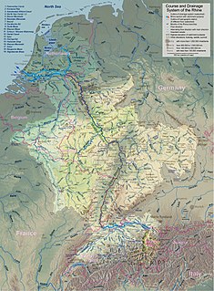
The Amsterdam–Rhine Canal is a canal in the Netherlands that was built to connect the port and capital city of Amsterdam to the main shipping artery of the Rhine. Its course follows a generally southeasterly direction as it goes through the city of Utrecht towards Wijk bij Duurstede where it intersects the Lek branch of the Rhine and then continues on to the river Waal near Tiel, with a branch, the Lek Canal, to the Lek near Nieuwegein.

Lek (river) river in the Netherlands

The Lek is a river in the western Netherlands of some 60 km (37 mi) in length. It is the continuation of the Nederrijn after the Kromme Rijn branches off at the town of Wijk bij Duurstede. The main westbound waterway is hereafter called the Lek River. The Nederrijn is, itself, a distributary branch of river Rhine.

Nederrijn Dutch part of the river Rhine

Nederrijn is the name of the Dutch part of the Rhine from the confluence at the town of Angeren of the cut-off Rhine bend of Oude Rijn and the Pannerdens Kanaal. The city of Arnhem lies on the right (north) bank of the Nederrijn, just past the point where the IJssel branches off. The Nederrijn flows on to the city of Wijk bij Duurstede, from where it continues as the Lek. The once-important but now small Kromme Rijn branch carries the name "Rhine" towards the city of Utrecht.

Vecht may refer to:

IJ (Amsterdam) lake, formerly a bay, in Amsterdam

The IJ is a body of water, formerly a bay, in the Dutch province of North Holland. It is known for being Amsterdam's waterfront. Its name is from an obsolete Dutch word meaning "water". The name consists of the digraph ij, which behaves like a single letter. Therefore both letters are capitalized; cf. IJmuiden.

Lower Rhine river

The Lower Rhine flows from Bonn, Germany, to the North Sea at Hoek van Holland, Netherlands ; alternatively, Lower Rhine may refer to the part upstream of Pannerdens Kop, excluding the Nederrijn.

Oog in Al

Oog in Al is a residential area in the west of the city of Utrecht in the Netherlands. The Amsterdam–Rhine Canal, the Merwede Canal and the Leidse Rijn canal form the area's limits, rendering it a man-made island in the shape of a triangle.

Oudegracht street in Utrecht, the Netherlands

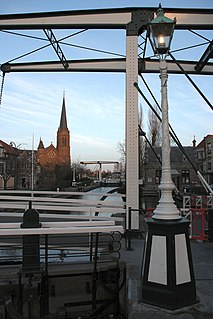
The Oudegracht, or "old canal", runs through the center of Utrecht, the Netherlands. It starts in the southeast of the city. Here the Kromme Rijn and the Vaartse Rijn arrive to meet the original moat of the fortified town, and the Oudegracht goes from there into the center of town. Parts of the Oudegracht follow the original flow of the river Rhine, but there is some disagreement on what parts. The northern part is most likely an early canal connecting the Rhine section to the river Vecht. The southern part was started in 1122, after the water level of the Rhine in Utrecht dropped because of the new dam at Wijk bij Duurstede. The ground excavated was used to raise the sides of the canal, to reduce the chance of flooding. When the city's system of locks was finished in 1275 the water level was constant, enabling the creation of permanently dry cellars and new quays at water level, hence the typical wharfs below street level. Warehouses used to line the canal. Today many of these warehouses have been converted into restaurants and cafés.

Vechtstreek region in the province of Utrecht and North Holland in the Netherlands

The Vechtstreek is a region in the Dutch provinces of Utrecht and North Holland along the Vecht River between the towns of Utrecht and Amsterdam. Located in the economic heartland of the Netherlands, it is known for its natural environment, castles, parks and stately homes.

Rhine–Meuse–Scheldt delta river delta in the Netherlands and Belgium

The Rhine–Meuse–Scheldt delta or Helinium is a river delta in the Netherlands formed by the confluence of the Rhine, the Meuse and the Scheldt rivers. The result is a multitude of islands, branches and branch names that may at first sight look bewildering, especially as a waterway that appears to be one continuous stream may change names as many as seven times, e.g. Rhine → Bijlands Kanaal → Pannerdens Kanaal → Nederrijn → Lek → Nieuwe Maas → Het Scheur → Nieuwe Waterweg. Since the Rhine contributes most of the water, the shorter term Rhine Delta is commonly used. However, this name is also used for the river delta where the Rhine flows into Lake Constance, so it is clearer to call the larger one Rhine–Meuse delta, or even Rhine–Meuse–Scheldt delta, as the Scheldt ends in the same delta. By some calculations, the delta covers 25,347 km2 (9,787 sq mi), making it the largest in Europe.

Vliet (canal) canal in South Holland, the Netherlands

The Vliet is a canal in the western Netherlands, in the province of South Holland. It starts at the Oude Rijn at Leiden and joins the Delfshavense Schie canal at Delft. Places along its banks include Voorschoten, Leidschendam, Voorburg, The Hague and Rijswijk.

Vaartse Rijn canal in the Netherlands

The Vaartse Rijn is a canal connecting the city of Utrecht with Nieuwegein and the Lek river in the Dutch province of Utrecht. The Vaartse Rijn was formerly a major shipping route between Utrecht and the Rhine basin.

References

  1. "Rivers of the World: the Vecht in Holland", Radio Netherlands Archives, January 31, 2003

Coordinates: 52°20′13″N5°04′08″E / 52.337°N 5.069°E / 52.337; 5.069

Geographic coordinate system Coordinate system

A geographic coordinate system is a coordinate system that enables every location on Earth to be specified by a set of numbers, letters or symbols. The coordinates are often chosen such that one of the numbers represents a vertical position and two or three of the numbers represent a horizontal position; alternatively, a geographic position may be expressed in a combined three-dimensional Cartesian vector. A common choice of coordinates is latitude, longitude and elevation. To specify a location on a plane requires a map projection.