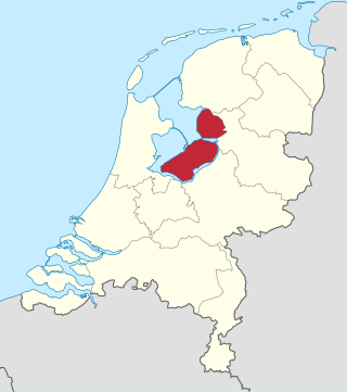
Flevoland is the twelfth and newest province of the Netherlands, established in 1986, when the southern and eastern Flevopolders, together with the Noordoostpolder, were merged into one provincial entity. It is in the centre of the country in the former Zuiderzee, which was turned into the freshwater IJsselmeer by the closure of the Afsluitdijk in 1932. Almost all of the land belonging to Flevoland was reclaimed in the 1950s and 1960s while splitting the Markermeer and Bordering lakes from the IJsselmeer. As to dry land, it is the smallest province of the Netherlands at 1,410 km2 (540 sq mi), but not gross land as that includes much of the waters of the fresh water lakes (meres) mentioned.

The IJsselmeer, also known as Lake IJssel in English, is a closed-off freshwater lake in the central Netherlands bordering the provinces of Flevoland, North Holland and Friesland. It covers an area of 1,100 km2 (420 sq mi) with an average depth of 4.5 m (15 ft). The river IJssel, after which the lake was named, flows into the IJsselmeer.

The Zuiderzee or Zuider Zee, historically called Lake Almere and Lake Flevo, was a shallow bay of the North Sea in the northwest of the Netherlands. It extended about 100 km inland and at most 50 km wide, with an overall depth of about 4 to 5 metres (13–16 feet) and a coastline of about 300 km. It covered 5,000 km2 (1,900 sq mi). Its name is Dutch for "southern sea", indicating that the name originates in Friesland, to the north of the Zuiderzee.
The Zuiderzee Works is a system of dams and dikes, land reclamation and water drainage work, which was the largest hydraulic engineering project undertaken by the Netherlands during the twentieth century. The project involved the damming of the Zuiderzee, a large, shallow inlet of the North Sea, and the reclamation of land in the newly enclosed water using polders. Its main purposes are to improve flood protection and create additional land for agriculture.

Almere is a planned city and municipality in the province of Flevoland, Netherlands across the IJmeer from Amsterdam.

The Amsterdam Metro is a rapid transit system serving Amsterdam, Netherlands, and extending to the surrounding municipalities of Diemen and Ouder-Amstel. Until 2019, it also served the municipality of Amstelveen, but this route was closed and converted into a tram line. The network is owned by the City of Amsterdam and operated by municipal public transport company Gemeente Vervoerbedrijf (GVB), which also operates trams, free ferries and local buses.
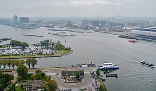
The IJ is a body of water, formerly a bay, in the Dutch province of North Holland. It is known for being Amsterdam's waterfront.

The Enneüs Heerma Bridge is a bridge in Amsterdam, Netherlands located in the new neighbourhood of IJburg, built on seven artificial islands in the IJmeer. It connects the district of Zeeburgereiland, on the eastern edge of the city, with Steigereiland, to the south.

Amsterdam Zuid is a railway station situated in the borough of Amsterdam-Zuid in Amsterdam, Netherlands. For a number of years, it was named Amsterdam Zuid WTC, in reference to the neighbouring World Trade Center Amsterdam. During 2006, in conjunction with the rapid development of the area surrounding the station, the station was enlarged and the reference to the WTC was formally dropped from the name.

IJburg is a residential neighbourhood under construction in Amsterdam, Netherlands. It is situated in the IJmeer and is being built on artificial islands which have been raised from the lake. The Haveneiland, Rieteilanden, Steigereiland and Centrumeiland are already inhabited as of 2004. It is part of the municipality Amsterdam-Oost and also contains the Diemerpark, one of the city's largest parks.

Almere Oostvaarders is a railway station in Almere, Netherlands. It is located 29 km (18.0 mi) east of Amsterdam, on the Amsterdam - Almere - Lelystad main line. It is approximately 3 km (1.9 mi) northeast of the Almere city centre. Almere Oostvaarders railway station opened on 12 December 2004.
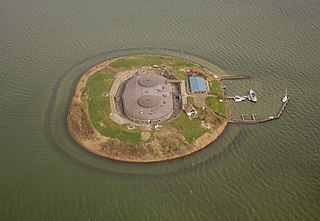
Pampus is an artificial island and late 19th-century sea fort located in the IJmeer near Amsterdam. Pampus now belongs to the municipality of Gooise Meren and is open to visitors.
The Markermeer is a 700 km2 (270 sq mi) lake in the central Netherlands in between North Holland, Flevoland, and its smaller and larger neighbors, the IJmeer and IJsselmeer. A shallow lake at 3 to 5 m in depth, matching the reclaimed land to its west, north-west and east it is named after the small former island, now peninsula, of Marken on its west shore.

Amsterdam-Oost is a borough of Amsterdam, Netherlands, established in May 2010 after a merger of the former boroughs of Zeeburg and Oost-Watergraafsmeer. In 2013, the borough had almost 123,000 inhabitants.

The Hollandse Brug is a bridge structure that crosses the Gooimeer and the IJmeer in the Netherlands. The bridge carries both the Flevolijn heavy rail railway and the A6 motorway, plus a cycleway and footway.

Almere Gate is a borough (stadsdeel) of Almere, Netherlands. It is the newest part of what is a new city itself, with the first building completed only in 2005. Although Almere is a planned city, Almere Poort was not in the original city plans, but is rather a result of revised urban planning in accordance to Almere's more recent development plans assuming much higher target population and more prominent role as a satellite urban centre to Amsterdam.
Teun Koolhaas was a Dutch architect and urban planner.

Christiaan Anton Jansen is a Dutch politician for the right-wing populist Party for Freedom (PVV). He has been serving as State Secretary for Public Transport and the Environment since July 2024, and he previously was a member of the House of Representatives between November 2019 and March 2021.
Floriade Expo Amsterdam - Almere 2022 was a Dutch horticultural exposition held in Almere, Netherlands. It is the seventh Floriade, held from 14 April to 9 October 2022. On 15 November 2017, Floriade Expo 2022 was officially recognized as a horticultural exhibition by the Bureau International des Expositions. The theme of the Expo is "Growing Green Cities", which focuses on the need to combine nature and cities.

Amsterdam tram line 26, popularly known as the IJtram, is a tram line operating between Amsterdam Centraal station and the IJburg district in Amsterdam, the Netherlands. As of 2019, the IJtram was the busiest tram line in Amsterdam, carrying 30,000 riders per day. The 8.5-kilometre (5.3 mi) line has 11 stops and a scheduled end-to-end travel time of 22 minutes. It is of existential importance to the IJburg district, as it is the only public transport connection to the city centre for a suburb that is growing to a population of 45,000. When it is interrupted a free replacement bus 76 operates.

