
Amsterdam is the capital and most populated city of the Netherlands. It has a population of 921,402 within the city proper, 1,457,018 in the urban area and 2,480,394 in the metropolitan area. Located in the Dutch province of North Holland, Amsterdam is colloquially referred to as the "Venice of the North", for its large number of canals, now a UNESCO World Heritage Site.
Muiden is a city and former municipality in the Netherlands, in the province of North Holland. It lies at the mouth of the Vecht and is in an area called the Vechtstreek. Since 2016, Muiden has been part of the new municipality of Gooise Meren.

The Stelling van Amsterdam, Defence Line of Amsterdam), is a 135-kilometre (84 mi) ring of fortifications around Amsterdam. It has 42 forts that are 10–15 kilometres (6.2–9.3 mi) from the centre and lowlands, which can easily be flooded in time of war. The flooding was designed to give a depth of about 30 centimetres (12 in), too little for boats to cross. Any buildings within 1 kilometre (0.62 mi) of the line had to be made of wood so that they could be burnt and the obstruction removed.

Kralendijk is the capital and main port of the island of Bonaire in the Caribbean Netherlands. The language spoken in the town is Papiamentu, but Dutch and English are widely used. As of 2017, the town had a population of 10,620. In Papiamentu, the town is often called Playa or "beach".

Amsterdam Centraal station is the largest railway station in Amsterdam, North Holland, the Netherlands. A major international railway hub, it is used by 192,000 passengers a day, making it the second busiest railway station in the country after Utrecht Centraal and the most visited Rijksmonument of the Netherlands.
The history of Curaçao starts with settlement by the Arawaks, an Amerindian people coming from the South American mainland. They are believed to have inhabited the island for many hundreds of years before the arrival of Europeans.

Amsterdam-Noord is a borough of Amsterdam, Netherlands with a population of about 90,000. The IJ, the body of water which separates it from Amsterdam-Centrum and the rest of the city, is situated southwest of Amsterdam-Noord. The borough, which has an area of 49.01 km2, borders the municipalities of Zaanstad, Oostzaan, Landsmeer and Waterland to the north, all part of the province of North Holland like Amsterdam. It borders the Markermeer to the east.

Schellingwoude is a neighbourhood of Amsterdam, Netherlands. A former village located on the northern shore of the IJ, in the province of North Holland, it was a separate municipality between 1817 and 1857, when it was merged with Ransdorp; the latter merged with Amsterdam in 1921. Nowadays it is part of the Amsterdam-Noord borough and the Landelijk Noord district.

Cornelis Nicolaas Hin was a sailor from the Netherlands, who represented his native country at the 1920 Summer Olympics in Ostend, Belgium.
Franciscus "Frans" Fidelio Joseph Hin was a sailor from the Netherlands, who represented his native country at the 1920 Summer Olympics in Ostend, Belgium.
Fort Wilhelmus was a factorij in the 17th-century colonial province of New Netherland, located on what had been named Hooghe Eyland on the Zuyd Rivier, now Burlington Island in the Delaware River in New Jersey. More a trading post than a military installation, it was built in 1625 by colonists from the Netherlands in the employ of the Dutch West India Company, with the intention of establishing a physical claim to the new territory and to engage in the fur trade with the indigenous population of Lenape and Minqua. The Walloon families had originally arrived at Noten Island across from New Amsterdam in the Upper New York Bay, They had been sent south in order to begin the population of the province of New Netherland. They were later recalled to Fort Amsterdam since the Dutch West India Company had decided to concentrate their settlement efforts along the North River, or Hudson River.

New Netherland, or Nieuw-Nederland in Dutch, was the 17th century colony of the Republic of the Seven United Netherlands on the northeastern coast of North America. The claimed territory included southern Cape Cod to parts of the Delmarva Peninsula. Settled areas are now part of the Mid-Atlantic states of New York, New Jersey, Connecticut, Delaware and Pennsylvania. Its capital, New Amsterdam, was located at the southern tip of the island of Manhattan on Upper New York Bay.
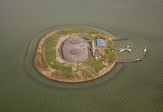
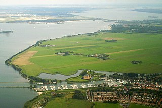
Pampus is an artificial island and late 19th-century sea fort located in the IJmeer near Amsterdam. Pampus now belongs to the municipality of Gooise Meren and is open to visitors.

The Eastern Docklands is a neighborhood of Amsterdam, Netherlands, located between the IJ and the Nieuwe Vaart in the borough of Amsterdam-Oost. The harbor area was constructed in the late nineteenth century to allow for increasing trade with the Dutch East Indies; a new location was necessitated by the construction of the Amsterdam Centraal railway station, which replaced the old quays. East of the new station was a marshy area called De Rietlanden, with the Zeeburgerdijk, running via the Zeeburch, a fort, to the Zuiderzee.
Java-eiland is a neighbourhood of Amsterdam, Netherlands. It is located on a peninsula, surrounded on three sides by water and on the east by the KNSM Island neighbourhood.

De Ven is a lighthouse in Oosterdijk, a village in the municipality of Enkhuizen, Netherlands. Built in 1699–1700, it is one of the oldest lighthouses in the Netherlands.
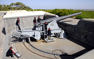
The 24 cm K L/35 was a German naval gun developed in the years before World War I that armed ships of the Imperial German Navy, Argentine Navy and the Austro-Hungarian Navy. Guns removed from ships of the Imperial German Navy were modified to perform Coastal Artillery and Railway Artillery roles and saw service in both world wars. The actual bore diameter was 23.8 cm (9.4 in), but the classification system for artillery rounded up to the next highest centimeter.
The following is an alphabetical list of articles related to Amsterdam. Amsterdam is the capital city of the Netherlands.

