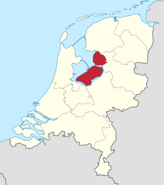
Flevoland is the twelfth and newest province of the Netherlands, established in 1986, when the southern and eastern Flevopolders, together with the Noordoostpolder, were merged into one provincial entity. It is in the centre of the country in the former Zuiderzee, which was turned into the freshwater IJsselmeer by the closure of the Afsluitdijk in 1932. Almost all of the land belonging to Flevoland was reclaimed in the 1950s and 1960s while splitting the Markermeer and Bordering lakes from the IJsselmeer. As to dry land, it is the smallest province of the Netherlands at 1,410 km2 (540 sq mi), but not gross land as that includes much of the waters of the fresh water lakes (meres) mentioned.

A polder is a low-lying tract of land that forms an artificial hydrological entity, enclosed by embankments known as dikes. The three types of polder are:
- Land reclaimed from a body of water, such as a lake or the seabed
- Flood plains separated from the sea or river by a dike
- Marshes separated from the surrounding water by a dike and subsequently drained; these are also known as koogs, especially in Germany

The IJsselmeer, also known as Lake IJssel in English, is a closed-off inland bay in the central Netherlands bordering the provinces of Flevoland, North Holland and Friesland. It covers an area of 1,100 km2 (420 sq mi) with an average depth of 4.5 m (15 ft). The river IJssel, which is what the lake was named after flows into the IJsselmeer.

The Zuiderzee or Zuider Zee was a shallow bay of the North Sea in the northwest of the Netherlands, extending about 100 km inland and at most 50 km wide, with an overall depth of about 4 to 5 metres (13–16 feet) and a coastline of about 300 km. It covered 5,000 km2 (1,900 sq mi). Its name is Dutch for "southern sea", indicating that the name originates in Friesland, to the north of the Zuiderzee.

Overijssel is a province of the Netherlands located in the eastern part of the country. The province's name translates to "across the IJssel", from the perspective of the Episcopal principality of Utrecht by which it was held until 1528. The capital city of Overijssel is Zwolle and the largest city is Enschede. The province had a population of about 1,184,000 as of January 2023. The land mostly consists of grasslands and some forests ; it also borders a small part of the IJsselmeer to the west.
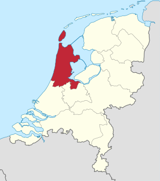
North Holland is a province of the Netherlands in the northwestern part of the country. It is located on the North Sea, north of South Holland and Utrecht, and west of Friesland and Flevoland. As of January 2023, it had a population of about 2,952,000 and a total area of 4,092 km2 (1,580 sq mi), of which 1,429 km2 (552 sq mi) is water.
The Zuiderzee Works is a system of dams and dikes, land reclamation and water drainage work, which was the largest hydraulic engineering project undertaken by the Netherlands during the twentieth century. The project involved the damming of the Zuiderzee, a large, shallow inlet of the North Sea, and the reclamation of land in the newly enclosed water using polders. Its main purposes are to improve flood protection and create additional land for agriculture.

Emmeloord is the administrative centre of the municipality of Noordoostpolder, Flevoland, Netherlands. In 2019, it had a population of 26,055.

Kraggenburg is a settlement in the Noordoostpolder area of the Netherlands.. The village is situated south east of the regional town Emmeloord.

Creil is one of the ten so-called green villages (Dutch: groendorpen) in the Dutch province of Flevoland. It is a part of the municipality of Noordoostpolder, and lies about 6 km northwest of Emmeloord.

Aartswoud is a village in the Dutch province of North Holland, part of the municipality of Opmeer. It lies about twelve kilometres (7.5 mi) northeast of Heerhugowaard.
The Netherlands has several levels of administrative subdivisions. The first level of subdivision consists of 12 provinces. The second level of subdivision consists of 342 municipalities.

The Flevopolder is an island polder forming the bulk of Flevoland, a province of the Netherlands. Created by land reclamation, its northeastern part was drained in 1955 and the remainder—the southwest—in 1968.
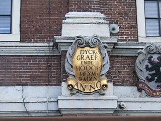
In the Netherlands, a water board, water council or water authority is a regional governing body solely charged with the management of surface water in the environment. Water boards are independent of administrative governing bodies like provinces and municipalities. In general, they are responsible for managing rivers and canals, issues with the flow of watercourses and drainage issues, water collection, flood and erosion prevention and provision of potable water. They manage polder systems, water levels, water barriers and locks, enforcements, water quality and sewage treatment in their respective regions. The concept of a coordinating "High Water Authority" (Hoogheemraadschap) originated in what now is the province of South Holland in the 12th century.

The Ketelmeer is the tongue of the IJsselmeer into which the River IJssel drains, it is situated between the polders Noordoostpolder and Oostelijk Flevoland, and connects the river IJssel to the IJsselmeer. It is one of the bordering lakes, a continuous body of water which separate Flevoland from the Noordostpolder and the ancient lands of the provinces of Gelderland and Utrecht. The Ketelmeer covers an area of 3500 hectares, most of which is in the province of Flevoland, but the river delta of the IJssel is in province of Overijssel.

The Kop van Overijssel is a region in the very northwestern part of the Dutch province of Overijssel. It consists of the municipality of Steenwijkerland and matches the historical region of the Land van Vollenhove. In past times it comprised a wider area, the municipalities of Kampen, Zwartewaterland and Staphorst also belonging to it.

The pilot Polder Andijk, or Test Polder Andijk, Proefpolder Andijk in Dutch, is a polder established in 1926 - 1927 in the Zuiderzee near the village of Andijk. The aim of this prototype is to study the embankments and agriculture for future polders in the Zuiderzee Works. In 1929, the pilot polder was inaugurated by Queen Wilhelmina of the Netherlands.
The Wieringerrandmeer or bordering lake of Wieringen is a project of the Dutch province of North Holland and the (former) municipalities of Wieringen and Wieringermeer. It is intended to create islands and a bordering lake. The project was cancelled in 2010 by the provincial and national governments.

Land reclamation in the Netherlands has a long history. As early as in the 14th century, the first reclaimed land had been settled. Much of the modern land reclamation has been done as a part of the Zuiderzee Works since 1919.

