Wolderwijd

Last updated
Wolderwijd

Wolderwijd.JPG

Wolderwijd as seen from Flevoland looking towards Harderwijk
2010-NL-P12-Flevoland-positiekaart-gemnamen.jpg
Red pog.svg
Wolderwijd
The Wolderwijd amongst the bordering lakes of the province of Flevoland
Netherlands relief location map.svg
Red pog.svg
Wolderwijd
Location within the Netherlands
Location Between Flevoland and Gelderland
Coordinates 52°20′50″N5°34′30″E / 52.34722°N 5.57500°E / 52.34722; 5.57500 Coordinates: 52°20′50″N5°34′30″E / 52.34722°N 5.57500°E / 52.34722; 5.57500
Type Bordering lake
Basin  countries Netherlands
Designation Ramsar wetland of international importance (2000)
Built 1963 (1963)
Average depth 1.7 m (5 ft 7 in)
Islands De Zegge, De Biezen
Settlements Harderwijk, Zeewolde

The Wolderwijd is a bordering lake situated in the Netherlands, created in 1967 by the gaining of land in Southern Flevoland. [1] It is one of four Veluwe bordering lakes. On the northern and western bank it is encompassed by the municipality of Zeewolde, in the Province of Flevoland, and on the southern and eastern bank it is encompassed by the municipality of Harderwijk in the Province of Gelderland. As the bordering lakes of Flevoland are strictly speaking one mass of water there are no exact markers on where the Wolderwijd ends and the adjacent lakes start. In the west near Strand Horst the Wolderwijd becomes the Nuldernauw and in the east at the aqueduct at the provincial road N302 it becomes the Veluwemeer. [1]

Bordering lakes

In the Netherlands, the bordering lakes are a chain of lakes which separate the Flevopolder from the ancient lands of the provinces of Gelderland and Utrecht and the Noordoostpolder.

Netherlands Constituent country of the Kingdom of the Netherlands in Europe

The Netherlands is a country located mainly in Northwestern Europe. The European portion of the Netherlands consists of twelve separate provinces that border Germany to the east, Belgium to the south, and the North Sea to the northwest, with maritime borders in the North Sea with Belgium, Germany and the United Kingdom. Together with three island territories in the Caribbean Sea—Bonaire, Sint Eustatius and Saba— it forms a constituent country of the Kingdom of the Netherlands. The official language is Dutch, but a secondary official language in the province of Friesland is West Frisian.

Flevoland Province of the Netherlands

Flevoland is the twelfth and last province of the Netherlands, established on 1 January 1986, when the southern and eastern Flevopolders were merged into one provincial entity. It is located in the centre of the country, where the former Zuiderzee was. Almost all of the land belonging to Flevoland was reclaimed only in the 1950s and 1960s. The province has about 407,905 inhabitants (2016) and consists of 6 municipalities. Its capital is Lelystad and most populous city Almere.

Contents

Use

The lake was created as a buffer between the old land of the Veluwe and the newly created Flevopolder, to ensure that the water level of the Veluwe would not drop. [1] The lake receives water from the neighboring Veluwemeer and several streams and sluices. An additional source is low-phosphate water from the Flevopolder to counter eutrophication. [2]

Veluwe forested hilly area with multiple kinds of terrain, including wetland and heathland

The Veluwe is a forest-rich ridge of hills (1100 km2) in the province of Gelderland in the Netherlands. The Veluwe features many different landscapes, including woodland, heath, some small lakes and Europe's largest sand drifts.

Flevopolder

The Flevopolder is a polder, or region of reclaimed land, in Flevoland, Netherlands. The eastern part was drained in 1955 and the southern part in 1968.

Eutrophication ecosystem response to the addition of substances

Eutrophication, or hypertrophication, is when a body of water becomes overly enriched with minerals and nutrients which induce excessive growth of algae. This process may result in oxygen depletion of the water body. One example is an "algal bloom" or great increase of phytoplankton in a water body as a response to increased levels of nutrients. Eutrophication is often induced by the discharge of nitrate or phosphate-containing detergents, fertilizers, or sewage into an aquatic system.

The Wolderwijd lake is used for commercial fishery, boating, shipping traffic, water management, and sand extraction. [2]

The lake, together with the Nuldernauw, has also been designated as a Ramsar wetland of international importance since 29 August 2000. It was designated as such because it held over 1% of relevant biogeographical populations of two bird species, the swan species Cygnus bewickii (1.6%) and the common pochard (Aythya ferina) (2.1%). [2]

Tundra swan species of bird

The tundra swan is a small Holarctic swan. The two taxa within it are usually regarded as conspecific, but are also sometimes split into two species: Bewick's swan of the Palaearctic and the whistling swan proper of the Nearctic. Birds from eastern Russia are sometimes separated as the subspecies C. c. jankowskii, but this is not widely accepted as distinct, with most authors including them in C. c. bewickii. Tundra swans are sometimes separated in the subgenus Olor together with the other Arctic swan species.

Common pochard duck

The common pochard is a medium-sized diving duck. The scientific name is derived from Greek aithuia an unidentified seabird mentioned by authors including Hesychius and Aristotle, and Latin ferina, "wild game", from ferus, "wild".

Related Research Articles

IJsselmeer lake in the Netherlands

The IJsselmeer, also known as Lake Ijssel in English, is a closed off inland bay in the central Netherlands bordering the provinces of Flevoland, North Holland and Friesland. It measures 1,100 km2 (420 sq mi) with an average depth of 5.5 m (18 ft). The river IJssel flows into the IJsselmeer.

Overijssel Province of the Netherlands

Overijssel is a province of the Netherlands located in the eastern part of the country. The province's name translates to "across the IJssel", from the perspective of the Episcopal principality of Utrecht by which it was held until 1528. The capital city of Overijssel is Zwolle and the largest city is Enschede. The province had a population of 1,142,360 in 2015.

Gelderland Province of the Netherlands

Gelderland, also known as Guelders in English, is a province of the Netherlands, located in the central eastern part of the country. With a land area of nearly 5,000 km2, it is the largest province of the Netherlands and shares borders with six other provinces and Germany.

Zuiderzee Works

The Zuiderzee Works is a man-made system of dams and dikes, land reclamation and water drainage work, in total the largest hydraulic engineering project undertaken by the Netherlands during the twentieth century. The project involved the damming of the Zuiderzee, a large, shallow inlet of the North Sea, and the reclamation of land in the newly enclosed water using polders. Its main purposes are to improve flood protection and create additional land for agriculture.

Zeewolde Municipality in Flevoland, Netherlands

Zeewolde is a municipality and a town in the Flevoland province in the central Netherlands. It has a population of approximately 20,000. It is situated in the polder of Flevoland with the small lake called the Wolderwijd to the east. To the south is a large deciduous forest called the Horsterwold. The area to the west is principally agricultural.

Oostvaardersplassen nature reserve in the Netherlands near Amsterdam

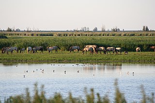
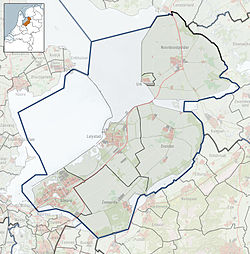
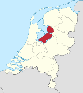
The Oostvaardersplassen is a nature reserve in the Netherlands, which is managed by the State Forestry Service. Covering about 56 square kilometres (22 sq mi), it is noted as an experiment of rewilding. It is in a polder which was created in 1968; by 1989, its ecological interest had resulted in its being declared a Ramsar wetland.

A Ramsar site is a wetland site designated to be of international importance under the Ramsar Convention.

Sasthamcotta Lake lake in Kerala, India

Sasthamcotta Lake or Sasthamkotta Lake, also categorized as a wetland, is the largest fresh water lake in Kerala, a state of India on the south of the West Coast. The lake is named after the ancient Sastha temple located on its bank. It meets the drinking water needs of half million people of the Quilon district and also provides fishing resources. The purity of the lake water for drinking use is attributed to the presence of large population of larva called cavaborus that consumes bacteria in the lake water. The lake is a designated wetland of international importance under the Ramsar Convention since November 2002.

Lake Skadar — also called Lake Scutari, Lake Shkodër and Lake Shkodra — lies on the border of Albania and Montenegro, and is the largest lake in Southern Europe. It is named after the city of Shkodër in northern Albania. It is a karst lake.

Veluwemeer lake in Harderwijk, Gelderland, Netherlands

The Veluwemeer (Dutch) or Lake Veluwe is a bordering lake in the Netherlands, between the provinces of Flevoland on the west side and Gelderland on the east side. It is a narrow lake that stretches from south-west to north-east. South of Harderwijk the lake becomes het Wolderwijd and North of Elburg het Drontermeer.

Ketelmeer lake in the Netherlands

The Ketelmeer is the tongue of the IJsselmeer into which the River IJssel drains, it is situated between the polders Noordoostpolder and Oostelijk Flevoland, and connects the river IJssel to the IJsselmeer. It is one of the bordering lakes, a continuous body of water which separate Flevoland from the Noordostpolder and the ancient lands of the provinces of Gelderland and Utrecht. The Ketelmeer covers an area of 3500 hectares, most of which is in the province of Flevoland, but the river delta of the IJssel is in province of Overijssel.

Markermeer lake in the Netherlands

The Markermeer is a 700 km2 (270 sq mi) lake in the central Netherlands in between North Holland, Flevoland and its larger sibling, the IJsselmeer. A shallow lake at some 3 to 5 m in depth, it is named after the small former island, now peninsula, of Marken that lies within it. The southwest side of the lake that begins where the IJ once emptied into the Zuiderzee is known as the IJmeer.

Bargerveen Nature Reserve

Bargerveen Nature Reserve is a nature reserve in the Dutch province of Drenthe that has been included in the Natura 2000 ecological network. Since 2006 it is part of the Internationaler Naturpark Bourtanger Moor-Bargerveen, a nature reserve located on both sides of the border between the Netherlands and Germany. Most of the transboundary nature reserve, some 134 km2 (52 sq mi), lies in Germany, in the west of the state of Lower Saxony. The sparsely populated landscape consists of large peat areas, heather, and small lakes.

Toolibin Lake lake in Australia

Toolibin Lake is a seasonal fresh to brackish water perched lake or wooded swamp, in south-western Australia. The lake is contained with a 493-hectare (1,218-acre) nature reserve and it is located about 200 kilometres (124 mi) south-east of Perth, in the Shire of Narrogin, and 40 kilometres (25 mi) east of the town of Narrogin, in the Wheatbelt region of Western Australia. The lake is listed by the Australian Government as a threatened ecological community under the Environment Protection and Biodiversity Conservation Act 1999.

The Forrestdale and Thomsons Lakes Ramsar Site comprises two separate nature reserves, totaling 754 ha in area, protecting two shallow fresh to brackish, seasonal lakes in a suburban and agricultural landscape in south-western Western Australia. It is used mainly for birdwatching and walking. It lies in the Swan Coastal Plain bioregion. The site is recognised as being of international importance under the Ramsar Convention on Wetlands, under which it was designated Ramsar Site 481 on 7 June 1990.

References

  1. 1 2 3 "Wolderwijd" (in Dutch). Rijkswaterstaat . Retrieved 7 May 2014.
  2. 1 2 3 "The Annotated Ramsar List: The Netherlands". The Ramsar Convention on Wetlands. 12 February 2013. Retrieved 7 May 2014.