Veluwe

Last updated • 4 min readFrom Wikipedia, The Free Encyclopedia
Veluwe
Region
Flag of Veluwe.svg
Area
  Total912 km2 (352 sq mi)
Population
 (2023)
  Total715,729
Website www.visitveluwe.nl
Heath on the Renderklippen nearby Heerde. Netherlands, Veluwe (3), Heerde, Renderklippen.jpg
Heath on the Renderklippen nearby Heerde.
2013-Top33-Veluwe.jpg
Netherlands Gelderland veluwe.svg
Maps of the Veluwe
Morning mist hangs over the Planken Wambuis, Ede, in the Veluwe Wandelen over de Planken Wambuis vanuit Mossel 069 A.jpg
Morning mist hangs over the Planken Wambuis, Ede, in the Veluwe

The Veluwe (Dutch pronunciation: [ˈveːlyʋə] ) is a forest-rich ridge of hills (1100 km2; 420 sq. mi.) in the province of Gelderland in the Netherlands. The Veluwe features many different landscapes, including woodland, heath, some small lakes and Europe's largest sand drifts.

Contents

The Veluwe is the largest push moraine complex in the Netherlands, stretching 60 km (40 miles) from north to south, and reaching heights of up to 110 metres (360'). The Veluwe was formed by the Saalian glacial during the Pleistocene epoch, some 200,000 years ago. Glaciers some 200 metres (600') thick pushed the sand deposits in the Rhine and Maas Delta sideways, creating the hills which now form most of the Veluwe. Because the hills are made of sand, rain water disappears rapidly, and then it flows at a depth of tens of metres (yards) to the edges where it reaches the surface again. [1]

Originally the Veluwe was surrounded by a string of swamps, heavily populated with game such as deer and wild boar because these areas offered rich vegetation to feed on. Since the 1990s many plans are underway, or have already been implemented, to restore these wetlands by blocking the drainage systems built by farmers during the last 150 years. This results in very dry heathland changing into wetland within a span of just a few hundred metres (yards). The Wisselse Veen near the village of Epe, on the northeastern Veluwe, offers a good example of this.[ citation needed ]

Etymology

Veluwe derives from Proto-Germanic *falwaz (pale, fallow) and *awjō (island). [2] The name corresponds to "fallow lands" in English and probably was used in opposition to the fertile "good lands" of the Betuwe (from *bataz, good, and *awjō, island) to the south.

Geography

The Veluwe area as seen from space Veluwe 5.88540E 52.13388N.jpg
The Veluwe area as seen from space

There are 21 municipalities in the Veluwe region: Apeldoorn, Arnhem, Barneveld, Brummen, Ede, Elburg, Epe, Ermelo, Harderwijk, Hattem, Heerde, Nijkerk, Nunspeet, Oldebroek, Putten, Renkum, Rheden, Rozendaal, Scherpenzeel, Voorst and Wageningen.

The sparsely populated, infertile Veluwe acts as the traditional linguistic boundary between Low Franconian dialects (i.e. essentially Dutch and closely related dialects) to the west and south and Low Saxon dialects further north and east. [3]

Flora and fauna

Red deer in the Hoge Veluwe National Park Cervus elaphus (Red deer), Veluwe, the Netherlands.jpg
Red deer in the Hoge Veluwe National Park

There are both coniferous and deciduous forests on the Veluwe, and some 500 different plant species can be found. The region is also home to many different species of animals, such as wild boar, several species of deer (like the roe deer, red deer and fallow deer), several species of snakes (including the common viper), pine martens, foxes, and badgers. Furthermore, the bird raven was successfully reintroduced, and the introduced Reeves's muntjac and mouflon can sometimes be seen. Furthermore, there live semi-wild and wild cattle and horses like both semi-wild and wild Highland cattle in multiple areas of the Veluwe, semi-wild Sayaguesa cattle and two semi-wild horse breeds: New-forest pony and Icelandic pony. Since 2019 the wolf is officially back with a female and male pair in the northern Veluwe (spring 2019) who had their offspring in the summer of 2019 and one female wolf in middle Veluwe. The prognosis are that many more wolves will reclaim the area. The European bison is also reintroduced as pilot in a fenced area in the Radio Kootwijk Reserve and the golden jackal is reaching the area, from which they are not native, but since the jackals reach the area all by their own they are seen as a welcome and new native species.

Developments

Parts of the Veluwe that have been separated from each other by roads, towns and farmland are being reconnected by returning farmland to nature and creating wildlife crossings over highways. In 2012, nine of these overpasses had been built, each one about 50 metres (200') wide and covered with sand and vegetation to encourage animals to use it. [4] Wildlife corridors connecting the Veluwe to other wildlife areas such as the Oostvaardersplassen in the Netherlands are being developed and further connections to Germany are an option. [5] It is hoped that by doing so the genetic diversity of the wildlife population will increase.

In order to turn the entire Veluwe into one IUCN (Category II) standard National Park a number of actions have been taken, or are planned, including: bungalow parks located in a more sensitive natural area have been removed; taking down remaining fences, as around De Hoge Veluwe; an old industrial zone near the village of Renkum was cleared away because it blocked a valley that was important for the migration of wildlife; and a military complex near Nunspeet was removed instead of being redeveloped as a business area.[ citation needed ]

Tourism and recreation

Kroller-Muller Museum in Otterlo Entrance Kroller-Muller Museum.JPG
Kröller-Müller Museum in Otterlo

The Veluwe is a tourist destination, especially for Dutch people wanting to go on a short vacation in their own country. Campsites and bungalow parks are the preferred place to stay for most visitors.[ citation needed ] There are more than 500 of these sites, most located on the outskirts of the natural area.

Tourist attractions in the area include four zoos, over 50 museums including the Kröller-Müller art museum, and the royal palace Het Loo at Apeldoorn. The National Sports Centre Papendal, a large sports complex and Olympic Games training facility, is located in the south of the Veluwe near Arnhem.

Related Research Articles

<span class="mw-page-title-main">Low Saxon</span> Group of Low German dialects

Low Saxon, also known as West Low German are a group of Low German dialects spoken in parts of the Netherlands, northwestern Germany and southern Denmark. It is one of two dialect groups, the other being East Low German.

<span class="mw-page-title-main">Gelderland</span> Province of the Netherlands

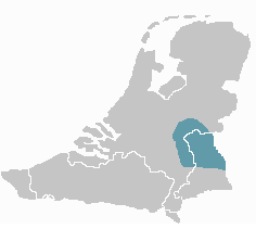
Gelderland, also known as Guelders in English, is a province of the Netherlands, occupying the centre-east of the country. With a total area of 5,136 km2 (1,983 sq mi) of which 176 km2 (68 sq mi) is water, it is the largest province of the Netherlands by land area, and second by total area. Gelderland shares borders with six other provinces and the German state of North Rhine-Westphalia.

<span class="mw-page-title-main">Apeldoorn</span> City and Municipality in Gelderland, Netherlands

Apeldoorn is a municipality and city in the province of Gelderland in the centre of the Netherlands. The municipality of Apeldoorn, including the of villages of Beekbergen, Loenen, Ugchelen and Hoenderloo, had a population of 165,525 on 1 December 2021. The western half of the municipality lies on the Veluwe ridge, with the eastern half in the IJssel valley.

<span class="mw-page-title-main">Nunspeet</span> Municipality in Gelderland, Netherlands

Nunspeet is a municipality and town in the central Netherlands. It has been an agricultural site since prehistoric times. The municipality contains a number of villages, namely Hulshorst, Elspeet, and Vierhouten. Nunspeet has a vivid historical foundation, called Nuwenspete. In 1972 Nunspeet became a separate municipality after having been part of Ermelo before.

<span class="mw-page-title-main">Low Franconian</span> Language family

In historical and comparative linguistics, Low Franconian is a linguistic category used to classify a number of historical and contemporary West Germanic varieties closely related to, and including, the Dutch language. Most dialects and languages included within this category are spoken in the Netherlands, northern Belgium (Flanders), in the Nord department of France, in western Germany, as well as in Suriname, South Africa and Namibia.

<span class="mw-page-title-main">Oostvaardersplassen</span> Nature reserve in the Netherlands

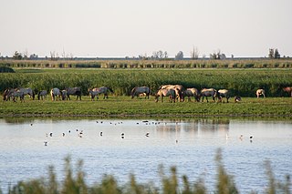
The Oostvaardersplassen is a nature reserve in the Netherlands, managed by the Staatsbosbeheer. Covering about 56 square kilometres (22 sq mi) in the province of Flevoland, it is an experiment in rewilding. It is in a polder created in 1968; by 1989, its ecological interest had resulted in its being declared a Ramsar wetland. It became part of Nieuw Land National Park when that was established in 2018.

<span class="mw-page-title-main">Dieren</span> Town in Gelderland, Netherlands

Dieren is a town in the eastern Netherlands. It is located in Rheden, Gelderland, between Zutphen and Arnhem, on the bank of the IJssel.

<span class="mw-page-title-main">Oosterbeek</span> Place in Gelderland, Netherlands

Oosterbeek is a village in the eastern part of Netherlands. It is located in the municipality of Renkum in the province of Gelderland, about 5 km (3.1 mi) west of Arnhem.

<span class="mw-page-title-main">West-Veluws dialect</span>

West-Veluws is a Low Franconian dialect of the Dutch province of Gelderland. It is spoken in several Veluwe municipalities and villages including: Nunspeet, Putten, Ermelo (Armelo), Harderwijk (Harderwiek), Uddel, Nijkerk (Niekark), Appel, Scherpenzeel (Schaarpezeel), the municipality of Barneveld (Barreveld) and some villages of the municipality of Ede.

<span class="mw-page-title-main">De Hoge Veluwe National Park</span> Dutch national park

De Hoge Veluwe National Park is a Dutch national park in the province of Gelderland near the cities of Ede, Wageningen, Arnhem and Apeldoorn. It is approximately 55 km2 in area, consisting of heathlands, sand dunes, and woodlands. It is situated in the Veluwe, the area of the largest terminal moraine in the Netherlands. Most of the landscape of the park and the Veluwe was created during the last ice age. The alternating sand dune areas and heathlands may have been caused by human utilization of the surrounding lands. The park forms one of the largest continuous nature reserves in the Netherlands.

<span class="mw-page-title-main">Emst</span> Village in Gelderland, Netherlands

Emst is a village in the municipality of Epe in the province of Gelderland in the Netherlands. It is the birthplace of former footballer Marc Overmars. Emst is located in the forest area of Veluwe.

<span class="mw-page-title-main">Vaassen</span> Town in Gelderland, Netherlands

Vaassen is one of four villages in the Dutch municipality of Epe. Vaassen is situated between Apeldoorn and Zwolle, on the eastern edge of the Veluwe in the province of Gelderland. Vaassen was an independent municipality up to 1 January 1818, when it merged with Epe.

<span class="mw-page-title-main">Kleverlandish</span> Low Franconian dialect group

Kleverlandish is a group of Low Franconian dialects spoken on both sides of the Dutch-German border along the Meuse and Rhine rivers.

<span class="mw-page-title-main">Zuid-Kennemerland National Park</span> Conservation area in North Holland, the Netherlands

Zuid-Kennemerland National Park is a conservation area on the west coast of the province of North Holland. It was established in 1995.

<span class="mw-page-title-main">Arnhem Centraal railway station</span> Railway station in Arnhem, Netherlands

Arnhem Centraal railway station is the largest railway station in the city of Arnhem in Gelderland, Netherlands. It was opened on 14 May 1845 and is located on the Amsterdam–Arnhem railway, the Arnhem–Leeuwarden railway and the Arnhem–Nijmegen railway. The station opened at the same time as the Amsterdam–Arnhem railway, that continues into Germany via the Oberhausen–Arnhem railway.

<span class="mw-page-title-main">Oost-Veluws dialect</span>

Oost-Veluws is a Low Saxon dialect of the Dutch province of Gelderland. The dialect is endangered as there are few native speakers left.

<span class="mw-page-title-main">Veluwezoom National Park</span> National park in Gelderland, the Netherlands

Veluwezoom National Park is a national park in the Netherlands located in the province of Gelderland. It is the oldest national park in the Netherlands. It has a surface area of about 50 square kilometers at the southeastern edge of the Veluwe, a complex of terminal push moraines from the Saalian glaciation. The park has a pronounced relief by Dutch standards, with its highest point at 110 metres (360 ft) above sea level. It is a private national park, owned by Vereniging Natuurmonumenten, the largest nature conservation organisation in the Netherlands.

This article discusses transport in Apeldoorn, the Netherlands. Apeldoorn is a city located 60 miles southeast of Amsterdam. The municipality has a population of about 156,000, with 138,000 living in the town itself.

<span class="mw-page-title-main">European route E35 in the Netherlands</span>

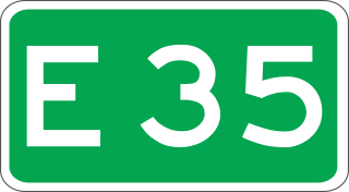
European route E 35 (E 35) is a north–south European route, running from Amsterdam in the Netherlands to Rome in Italy. In the Netherlands, the highway runs from its northern terminus in Amsterdam eastwards through Utrecht and Arnhem to the German border, near Zevenaar. The road runs concurrently with three other motorways over its entire length, starting on Rijksweg 10 (A10) around Amsterdam, then A2 from southern Amsterdam up to Utrecht, and the last part on A12 until it reaches the German border in the east.

The evacuation of Arnhem was the departure, forcibly conducted by the German Wehrmacht, of tens of thousands of inhabitants of the Dutch city of Arnhem and nearby places from 23 to 25 September 1944 during the Battle of Arnhem in World War II. The occupying German forces decided to evacuate almost the entire civilian population in order to better defend the city against the Allied Operation Market Garden. After the city was evacuated, many houses and other buildings were looted by various groups of organised and unorganised German soldiers and pro-German collaborators.

References

  1. Martens, Anne (April 30, 2008). "Stuwwal". Geologie van Nederland. Geologie van Nederland. Retrieved December 5, 2019.
  2. Nederlands Etymologisch Woordenboek - J. de Vries
  3. Confer these maps: https://en.wikipedia.org/wiki/Low_Franconian#/media/File:Niederfr%C3%A4nkisch.png and https://de.wikipedia.org/wiki/Westf%C3%A4lische_Dialekte#/media/Datei:Dialekte_in_Nordrhein-Westfalen.PNG
  4. (in Dutch) Province of Gelderland, factsheet wildlife crossings
  5. L. Verbeek; A.E. Bliek-de Jong (October 2010). "Oostvaardersland. Strengthening biodiversity and the economy in the Netherlands" (PDF). Presentation at the Convention on Biological Diversity, Nagoya, Japan. Archived from the original (PDF) on 17 October 2014. Retrieved 20 August 2013.

52°06′N5°54′E / 52.1°N 5.9°E / 52.1; 5.9