There is a railroad bridge over the narrow west side, between Weesp and Almere Poort, with a parallel highway bridge, the Hollandse Brug. The narrow eastern border of the lake is crossed by two parallel highway bridges.
On the south bank of Gooimeer, which used to be the IJsselmeer, before the creation of the new polder Flevoland, the old cities of Naarden and Huizen can be found. The Naarderwoonbos, part of the Naarderbos, was built in the eighties. It is situated directly adjacent to the southern shore of the Gooimeer.
The Gooimeer is related to the crash of El Al Flight 1862 in 1992, as the two right-hand side jet engines separated from the plane and fell into the lake, witnessed by a fishing off-duty police officer. The plane suffered serious damage to its right wing after losing its engines, and later continued on for eight minutes until it crashed into the Bijlmermeer apartment complex, killing all four of the plane's occupants and also several residents inside the building.
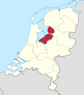
Flevoland is the twelfth and youngest province of the Netherlands, established in 1986, when the southern and eastern Flevopolders, together with the Noordoostpolder, were merged into one provincial entity. It is in the centre of the country in the former Zuiderzee, which was turned into the freshwater IJsselmeer by the closure of the Afsluitdijk in 1932. Almost all of the land belonging to Flevoland was reclaimed in the 1950s and 1960s while splitting the Markermeer and Bordering lakes from the IJsselmeer. As to dry land, it is the smallest province of the Netherlands at 1,412 km2 (545 sq mi), but not gross land as that includes much of the waters of the fresh water lakes (meres) mentioned.
Overijssel is a province of the Netherlands located in the eastern part of the country. The province's name translates to "across the IJssel", from the perspective of the Episcopal principality of Utrecht by which it was held until 1528. The capital city of Overijssel is Zwolle and the largest city is Enschede. The province had a population of 1,162,215 as of November 2019. The land mostly consists of grasslands and some forests ; it also borders a small part of the IJsselmeer to the west.
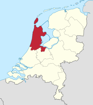
North Holland is a province of the Netherlands in the northwestern part of the country. It is located on the North Sea, north of South Holland and Utrecht, and west of Friesland and Flevoland. In November 2019, it had a population of 2,877,909 and a total area of 4,092 km2 (1,580 sq mi), of which 1,430 km2 (550 sq mi) is water.
Interstate 87 (I-87) is a 333.49-mile-long (536.70 km) north–south Interstate Highway located entirely within the US state of New York. It is most of the main highway between New York City and Montreal. The highway begins at exit 47 off I-278 in the New York City borough of the Bronx, just north of the Robert F. Kennedy Bridge and Grand Central Parkway. From there, the route runs northward through the Hudson Valley, the Capital District, and the easternmost part of the North Country to the Canadian border in the town of Champlain. At its north end, I-87 continues into Quebec as Autoroute 15 (A-15). I-87 connects with several regionally important roads: I-95 in New York City, New York State Route 17 near Harriman, I-84 near Newburgh, and I-90 in Albany. The highway is not contiguous with I-87 in North Carolina.
Delta Air Lines Flight 1141 was a scheduled domestic passenger flight between Dallas/Fort Worth, Texas and Salt Lake City, Utah. On August 31, 1988, the flight, using a Boeing 727-200 series aircraft, crashed during takeoff, resulting in 14 deaths and 76 injuries of the 108 on board.
U.S. Route 79 is a United States highway in the Southern United States. The route is officially considered and labeled as a north-south highway, but its path is actually more of a diagonal northeast-southwest highway. The highway's northern/eastern terminus is in Russellville, Kentucky, at an intersection with U.S. Route 68 and KY 80. Its southern/western terminus is in Round Rock, Texas, at an interchange with Interstate 35, ten miles (16 km) north of Austin. US 79, US 68, and Interstate 24/US 62 are the primary east–west access points for the Land Between the Lakes recreation area straddling the Kentucky/Tennessee border.
The river Narva, formerly also Narwa or Narova, flows 77 kilometres (48 mi) north into the Baltic Sea and is the largest Estonian river by discharge. A similar length of land far to the south, together with it and a much longer intermediate lake, Lake Peipus, all together nowadays form the international border between Estonia and Russia.
Highway 20, also known as the Chilcotin Highway, and officially dubbed the Alexander MacKenzie Highway, is one of the two main East-West routes in the Central Interior of British Columbia (the other being Highway 16. The Chilcotin Highway runs 457 km from Williams Lake westward through the Chilcotin region to North Bentinck Arm, an inlet from the Pacific Ocean where the town of Bella Coola is located. As of 2006, all but 57 km has been paved, mostly for expediting the removal of timber from the region, which, like most of British Columbia, is afflicted with pine beetle infestations. Logging traffic and ranch-related traffic on the route can be expected.
New York State Route 22 (NY 22) is a north–south state highway that parallels the eastern border of the U.S. state of New York, from the outskirts of New York City to the hamlet of Mooers in Clinton County near the Canadian border. At 337 miles (542 km), it is the state's longest north–south route and the third longest state route overall, after NY 5 and NY 17. Many of the state's major east–west roads intersect with, and often join, NY 22 just before crossing into the neighboring New England states, where U.S. Route 7 (US 7), which originally partially followed NY 22's alignment, similarly parallels the New York state line.
Interstate 94 (I-94) is a part of the Interstate Highway System that runs from Billings, Montana, to the Lower Peninsula of the US state of Michigan. In Michigan, it is a state trunkline highway that enters the state south of New Buffalo and runs eastward through several metropolitan areas in the southern section of the state. The highway serves Benton Harbor–St. Joseph near Lake Michigan before turning inland toward Kalamazoo and Battle Creek on the west side of the peninsula. Heading farther east, I-94 passes through rural areas in the middle of the southern Lower Peninsula, crossing I-69 in the process. I-94 then runs through Jackson, Ann Arbor, and portions of Metro Detroit, connecting Michigan's largest city to its main airport. Past the east side of Detroit, the Interstate angles northeasterly through farmlands in The Thumb to Port Huron, where the designation terminates on the Blue Water Bridge at the Canadian border.
U.S. Route 17 (US 17) in Florida is a north–south United States Highway. It runs 317 miles (510 km) from the Punta Gorda, Florida Metropolitan Statistical Area northeast to the Greater Jacksonville Metropolitan Area.
U.S. Highway 41 (US 41) in the state of Florida is a north–south United States Highway. It runs 479 miles (771 km) from Miami in South Florida northwest to the Georgia state line north of the Lake City area. Within the state, US 41 is paralleled by Interstate 75 (I-75) all the way from Miami to Georgia, and I-75 has largely supplanted US 41 as a major highway.
U.S. Route 90 (US 90) in the state of Florida is the northernmost east–west United States Numbered Highway in the state. US 90 passes through the county seats of all 15 counties on its course in Florida, and it is also the road upon which many of the county courthouses are located. It is never more than six miles (9.7 km) from Interstate 10 (I-10) throughout the state. It runs as a two-lane highway through most of the sparsely populated inland areas of the Florida Panhandle, widening to four lanes through and near several towns. The speed limit is 55 mph (89 km/h) for all rural points west of Monticello, and it is 60 mph (97 km/h) on all rural points beginning in Madison County to Glen St. Mary.
The Flevopolder is an island polder forming the bulk of Flevoland, a province of the Netherlands. Created by land reclamation, its northeastern part was drained in 1955 and the remainder—the southwest—in 1968.
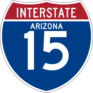
Interstate 15 (I-15) is an Interstate Highway, running from San Diego, California, United States, to the Canada–US border, through Mohave County in northwest Arizona. Despite being isolated from the rest of Arizona, in the remote Arizona Strip, and short in length at 29.43 miles (47.36 km), it remains notable for its scenic passage through the Virgin River Gorge. The highway heads in a northeasterly direction from the Nevada border northeast of Mesquite, Nevada, to the Utah border southwest of St. George, Utah.
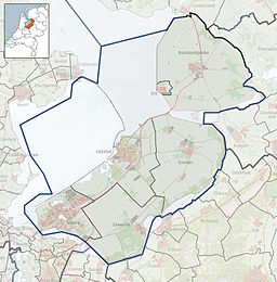
The Eemmeer is a lake situated in the middle of the Netherlands between the provinces of Flevoland, Utrecht, and North Holland. It measures 13.4 square kilometres (5.2 sq mi) and contains one small island, the Dode Hond. The Eemmeer is one in a series of peripheral lakes used to geohydrologically detach the low-lying polders of Flevoland from higher old mainland. The Eemmeer is connected to the peripheral lakes Gooimeer in the west, at the point where both lakes are crossed by the highway A27 bridge, and the Nijkerkernauw in the east.
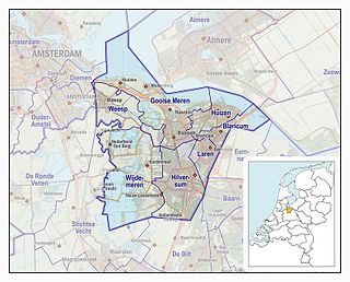
The Gooi is an area around Hilversum, in the centre of the Netherlands. It is a slightly hilly area characterised by its green landscape, its historical charm, the wealth of its inhabitants, and its villas. The Gooi is known in the Netherlands as the home of the rich and famous.
The IJmeer is a 'bordering lake' (Randmeer) in the Netherlands. It lies between the De Nes polder, Pampushaven, Hollandse Brug and the mouth of the IJ in IJburg, straddling the provinces of North Holland and Flevoland. It is an important habitat for birds such as the tufted duck and scaup. To the north-east is the Markermeer, south-east is the Gooimeer.
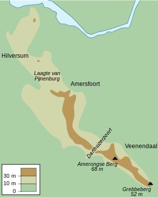
Utrecht Hill Ridge is a ridge of low sandhills that stretches in a direction from southeast to northwest over the Dutch province of Utrecht and over a part of North Holland. The total length of the region is about 50 km. It covers an area of approximately 23,000 hectares. The part of the ridge in North Holland is commonly called Het Gooi in Dutch, the Gooi (area) in English.
National Highway 66, commonly referred to as NH 66, is a mostly 4 lane 1,608 km (999 mi) long busy National Highway that runs roughly north–south along the western coast of India, parallel to the Western Ghats. It connects Panvel to Cape Comorin (Kanyakumari), passing through the states of Maharashtra, Goa, Karnataka, Kerala and Tamil Nadu.
This page is based on this Wikipedia article Text is available under the CC BY-SA 4.0 license; additional terms may apply. Images, videos and audio are available under their respective licenses.