Naarderbos

Last updated
Naarderbos
Recreational area / hamlet
Naarden-naarderbos01.jpg
Naarderwoonbos
Netherlands location map.svg
Red pog.svg
Naarderbos
Location in the Netherlands
2010-NL-P07-Noord-Holland-positiekaart-gemnamen.jpg
Red pog.svg
Naarderbos
Location in the province of North Holland in the Netherlands
Coordinates: 52°18′32″N5°9′07″E / 52.30889°N 5.15194°E / 52.30889; 5.15194 Coordinates: 52°18′32″N5°9′07″E / 52.30889°N 5.15194°E / 52.30889; 5.15194
Country Netherlands
Province North Holland
Municipality Dijk en Waard
Area
[1]
  Total0.55 km2 (0.21 sq mi)
Elevation
[2]
1.2 m (3.9 ft)
Population
 (2021) [1]
  Total460
  Density840/km2 (2,200/sq mi)
Time zone UTC+1 (CET)
  Summer (DST) UTC+2 (CEST)
Postal code
1411 [1]
Dialing code 035

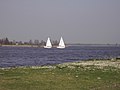
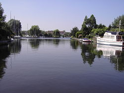
Naarderbos is a recreational area in the Gooi region in the province of North Holland in the Netherlands. It is situated on the shores of the Gooimeerlake and is part of the city of Naarden. It consists partly of woodland and meadows and has a villa closed community also referred to as "Naarderwoonbos". This community consists of approx. 180 villas, which each having its own boat pier as well as a public 18 hole golf course.

Contents

A beach was created and 3 urban villas were erected during 2007. The Naarderbos is a forest that was planted in 1980. It is a recreation park and some facilities such as golf and beaches are available. The Naarderbos consists mostly of oak, chestnut and beech-wood trees and it has many paths for walking, as well as picnic areas. The Naarderbos is about 20 km southeast of Amsterdam. Naarderbos also has a wild variety of animals. There have been sightings of moles, snakes, ferrets and a variety of bird species. There is a family of storks that live there and visit during the summer and there is also an overpopulated species of wild brown rabbits. There is also a hotel located nearby, only about 550 meters away from the new beach.

Related Research Articles

Amsterdam Capital and most populous city of the Netherlands

Amsterdam is the capital and most populous city of the Netherlands; with a population of 907,976 within the city proper, 1,558,755 in the urban area and 2,480,394 in the metropolitan area. Found within the Dutch province of North Holland, Amsterdam is colloquially referred to as the "Venice of the North", due to the large number of canals which form a UNESCO World Heritage Site.

Brussels Capital region of Belgium

Brussels, officially the Brussels-Capital Region, is a region of Belgium comprising 19 municipalities, including the City of Brussels, which is the capital of Belgium. The Brussels-Capital Region is located in the central portion of the country and is a part of both the French Community of Belgium and the Flemish Community, but is separate from the Flemish Region and the Walloon Region. Brussels is the most densely populated and the richest region in Belgium in terms of GDP per capita. It covers 162 km2 (63 sq mi), a relatively small area compared to the two other regions, and has a population of over 1.2 million. The five times larger metropolitan area of Brussels comprises over 2.5 million people, which makes it the largest in Belgium. It is also part of a large conurbation extending towards Ghent, Antwerp, Leuven and Walloon Brabant, home to over 5 million people.

Hilversum City and municipality in North Holland, Netherlands

Hilversum is a city and municipality in the province of North Holland, Netherlands. Located in the heart of the Gooi, it is the largest urban centre in that area. It is surrounded by heathland, woods, meadows, lakes, and smaller towns. Hilversum is part of the Randstad, one of the largest conurbations in Europe, and the Amsterdam metropolitan area.

The Hague City and municipality in South Holland, seat of government of the Netherlands

The Hague is a city and municipality on the western coast of the Netherlands on the North Sea. It is the administrative and royal capital of the Netherlands and its seat of government, as well as the capital of the province of South Holland. It hosts the International Court of Justice and International Criminal Court.

Bussum Town and former municipality in North Holland, Netherlands

Bussum is a commuter town and former municipality in the Gooi region in the south east of the province of North Holland in the Netherlands near Hilversum. Since 2016, Bussum has been part of the new municipality of Gooise Meren.

Naarden City in North Holland, Netherlands

Naarden is a city and former municipality in the Gooi region in the province of North Holland, Netherlands. It has been part of the new municipality of Gooise Meren since 2016.

Ostend Municipality in Flemish Community, Belgium

Ostend is a coastal city and municipality, located in the province of West Flanders in the Flemish Region of Belgium. It comprises the boroughs of Mariakerke, Raversijde, Stene and Zandvoorde, and the city of Ostend proper – the largest on the Belgian coast.

Municipalities of the Netherlands Second-level administrative divisions in the Netherlands

As of 24 March 2022, there are 344 municipalities and three special municipalities in the Netherlands. The latter is the status of three of the six island territories that make up the Dutch Caribbean. Municipalities are the second-level administrative division, or public bodies, in the Netherlands and are subdivisions of their respective provinces. Their duties are delegated to them by the central government and they are ruled by a municipal council that is elected every four years. Municipal mergers have reduced the total number of municipalities by two-thirds since the first official boundaries were created in the mid 19th century. Municipalities themselves are informally subdivided into districts and neighbourhoods for administrative and statistical purposes.

Aerdenhout Village in North Holland, Netherlands

Aerdenhout is a village in the municipality of Bloemendaal, Netherlands. Located in the dunes between Haarlem and the beach town of Zandvoort, it ranks as the wealthiest town in the Netherlands. The name "Aerdenhout" means Andere hout, Dutch for "the other wood", and was given it to distinguish this other wood from the Haarlemmerhout, just south of the city Haarlem.

Porthcawl Human settlement in Wales

Porthcawl is a town and community on the south coast of Wales in the county borough of Bridgend, 25 miles (40 km) west of the capital city, Cardiff and 19 miles (31 km) southeast of Swansea. Historically part of Glamorgan and situated on a low limestone headland on the South Wales coast, overlooking the Bristol Channel, Porthcawl developed as a coal port during the 19th century, but its trade was soon taken over by more rapidly developing ports such as Barry. Northwest of the town, in the dunes known as Kenfig Burrows, are hidden the last remnants of the town and Kenfig Castle, which were overwhelmed by sand about 1400.

Fripp Island, South Carolina Census-designated place in South Carolina, United States

Fripp Island is a 6.546 sq mi (16.954 km²) barrier island and census-designated place (CDP) located along the Atlantic coast of the lowcountry part of South Carolina. It was first listed as a CDP in the 2020 census with a population of 963.

Los Cabos Municipality Municipality in Baja California Sur, Mexico

Los Cabos is a municipality located at the southern tip of Mexico's Baja California Peninsula, in the state of Baja California Sur. It encompasses the two towns of Cabo San Lucas and San José del Cabo linked by a thirty-two-km Resort Corridor of beach-front properties and championship golf courses.

Muiderberg Village in North Holland, Netherlands

Muiderberg is a village in the municipality of Gooise Meren in the Netherlands. It lies about 6 km north of Bussum and 2 km west of Naarden, adjacent to the Naarderbos.

Vilamoura Resort in Algarve, Portugal

Vilamoura is a coastal resort in the Loulé municipality in Algarve, Portugal. It is one of the three corners of Algarve's Golden Triangle. Vilamoura comprises one of the largest single tourist complexes in Europe and with about 2,000 hectares of land. The nearest airport is in Faro.

Villamartin is the name of both an urbanisation and a golf course in the Costa Blanca area of eastern Spain. It lies in the municipality of Orihuela, in the province of Alicante in the Valencian Community.

Appelscha Village in Friesland, Netherlands

Appelscha is a village in the municipality of Ooststellingwerf in the province of Friesland, the Netherlands. It has just under 4800 inhabitants.

Gooi Area around Hilversum, the Netherlands

The Gooi is an area around Hilversum, in the centre of the Netherlands. It is a slightly hilly area characterised by its green landscape, its historical charm, the wealth of its inhabitants, and its villas. The Gooi is known in the Netherlands as the home of the rich and famous.

Biodiversity in Suriname

Biodiversity in Suriname is high, mostly because of the variety of habitats and the temperature. The average annual temperature in the coastal area is between 26° and 28° Celsius. Suriname can be divided into four major ecological zones, namely from north to south;

  1. The young coastal plain
  2. The old coastal plain
  3. The Savannah or Zanderij belt
  4. The interior residual uplands.
Gooise Meren Municipality in North Holland, Netherlands

Gooise Meren is a municipality in the province of North Holland, the Netherlands. It has about 56,000 inhabitants and covers an area of about 77 km2 (30 sq mi).

Kijkduin en Ockenburgh Place in South Holland, Netherlands

Kijkduin en Ockenburgh is a Dutch subdistrict of the Loosduinen district in The Hague. The subdistrict is located in the western part of The Hague at the municipal border of Monster. The area is bordered by the North Sea, an imaginary line between beach pole 105 and the De Savornin Lohmanlaan, the Machiel Vrijenhoeklaan, the Duinlaan, the Kijkduinsestraat, the Ockenburghstraat, the Loosduinse Hoofdstraat, the Monsterseweg and the municipal border with Monster. As the name suggests, the subdistrict consists of two neighborhoods Kijkduin and Ockenburgh.

References

  1. 1 2 3 "Kerncijfers wijken en buurten 2021". Central Bureau of Statistics. Retrieved 29 April 2022.
  2. "Postcodetool for 1411AA". Actueel Hoogtebestand Nederland (in Dutch). Het Waterschapshuis. Retrieved 29 April 2022.