Related Research Articles
Flevoland is the twelfth and newest province of the Netherlands, established in 1986, when the southern and eastern Flevopolders, together with the Noordoostpolder, were merged into one provincial entity. It is in the centre of the country in the former Zuiderzee, which was turned into the freshwater IJsselmeer by the closure of the Afsluitdijk in 1932. Almost all of the land belonging to Flevoland was reclaimed in the 1950s and 1960s while splitting the Markermeer and Bordering lakes from the IJsselmeer. As to dry land, it is the smallest province of the Netherlands at 1,410 km2 (540 sq mi), but not gross land as that includes much of the waters of the fresh water lakes (meres) mentioned.

ƒnam

The Zuiderzee or Zuider Zee was a shallow bay of the North Sea in the northwest of the Netherlands, extending about 100 km inland and at most 50 km wide, with an overall depth of about 4 to 5 metres (13–16 feet) and a coastline of about 300 km. It covered 5,000 km2 (1,900 sq mi). Its name is Dutch for "southern sea", indicating that the name originates in Friesland, to the north of the Zuiderzee.
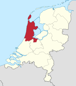
North Holland is a province of the Netherlands in the northwestern part of the country. It is located on the North Sea, north of South Holland and Utrecht, and west of Friesland and Flevoland. As of January 2023, it had a population of about 2,952,000 and a total area of 4,092 km2 (1,580 sq mi), of which 1,429 km2 (552 sq mi) is water.
The Zuiderzee Works is a system of dams and dikes, land reclamation and water drainage work, which was the largest hydraulic engineering project undertaken by the Netherlands during the twentieth century. The project involved the damming of the Zuiderzee, a large, shallow inlet of the North Sea, and the reclamation of land in the newly enclosed water using polders. Its main purposes are to improve flood protection and create additional land for agriculture.

Zeewolde is a municipality and a town in the Flevoland province in the central Netherlands. It has a population of approximately 22,000 (2017). It is situated in the polder of Flevoland with the small lake called the Wolderwijd to the east. To the south is a large deciduous forest called the Horsterwold. The area to the west is principally agricultural.
Wieringen is part of the municipality of Hollands Kroon, established in 2012 in the province of North Holland in the Netherlands. It is a former municipality in this province, with its name appearing in records of the late 9th and early 10th century. From 1200 it was known as an island, also named Wieringen, which was separated by water from the mainland during one of the disastrous storm floods towards the end of the late Middle Ages that changed the coastline. By draining, dikes and landfill from 1924 to 1932, the island was rejoined to the mainland.

Wieringermeer is a former municipality and a polder in the Netherlands, in the province of North Holland. Since 2012 Wieringermeer has been a part of the new municipality of Hollands Kroon.

The Afsluitdijk is a major dam and causeway in the Netherlands. It was constructed between 1927 and 1932 and runs from Den Oever in North Holland province to the village of Zurich in Friesland province, over a length of 32 kilometres (20 mi) and a width of 90 metres (300 ft), at an initial height above Amsterdam Ordnance Datum of between 6.7 metres (22 ft) along the section at Friesland, and 7.4 metres (24 ft) where it crosses the deep channel of the Vlieter. The height at the greater sea depths west of Friesland was required to be a minimum of 7 metres everywhere when originally constructed.

On 17 April 1945, the retreating German occupying forces inundated the polder of Wieringermeer, the Netherlands.
Wieringerwerf is a town in the Dutch province of North Holland. It is a part of the municipality of Hollands Kroon, and lies about 21 kilometres (13 mi) southeast of Den Helder. It is situated in a polder. The elevation of the village is 4 metres (13 ft) below sea level. Dikes and pumping engines keep the land dry.

The Markerwaard is the name of a proposed, but never built, polder adjoining the IJsselmeer in the central Netherlands. Its construction would have resulted in the near-total reclamation of the Markermeer.

Creil is one of the ten so-called green villages (Dutch: groendorpen) in the Dutch province of Flevoland. It is a part of the municipality of Noordoostpolder, and lies about 6 km northwest of Emmeloord.
Oosterland is a village in the Dutch province of North Holland. It is a part of the municipality of Hollands Kroon, and lies about 17 kilometres (11 mi) southeast of Den Helder. From 1918 to 1923, Oosterland was the residence of the exiled German crown prince, Friedrich Wilhelm von Hohenzollern.

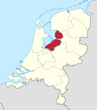
The Flevopolder is an island polder forming the bulk of Flevoland, a province of the Netherlands. Created by land reclamation, its northeastern part was drained in 1955 and the remainder—the southwest—in 1968.

The pilot Polder Andijk, or Test Polder Andijk, Proefpolder Andijk in Dutch, is a polder established in 1926 - 1927 in the Zuiderzee near the village of Andijk. The aim of this prototype is to study the embankments and agriculture for future polders in the Zuiderzee Works. In 1929, the pilot polder was inaugurated by Queen Wilhelmina of the Netherlands.
Amsteldiepdijk is a dike between Van Ewijcksluis and the island of Wieringen. It was built in 1924 and closes a portion of the Amsteldiep and of the Ulkediep.

In the Netherlands, the bordering lakes are a chain of lakes which separate the Flevopolder and Noordoostpolder from the ancient lands of the provinces of Gelderland, Utrecht, Overijssel and Friesland.

The Marker Wadden is an artificial archipelago under development in the Markermeer, a lake in the Netherlands. The first island was inaugurated on 24 September 2016. It is a nature reserve alternative to the much bigger proposed Markerwaard polder that was begun in 1941, but paused following World War II and finally canceled in 2003.

Land reclamation in the Netherlands has a long history. As early as in the 14th century, the first reclaimed land had been settled. Much of the modern land reclamation has been done as a part of the Zuiderzee Works since 1919.
References
- ↑ "Plan Wieringerrandmeer niet gepresenteerd". Archived from the original on 2010-12-21. Retrieved 2012-08-22.