
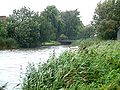
The Rotte is a river in the Rhine-Maas-delta in the Netherlands. The Rotte is the eponym of the city of Rotterdam: the city was founded in the 13th century when a dam was built along the river.
The Rotte is a river in the Rhine-Maas-delta in the Netherlands. The Rotte is the eponym of the city of Rotterdam: the city was founded in the 13th century when a dam was built along the river.
The river was originally named Rotta, from rot, meaning "muddy" and aa meaning "water," thus "muddy water."[ citation needed ]
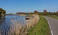
It rises in Moerkapelle in the so-called Green Heart. It used to drain the Zuidplas lake until it was reclaimed in 1840.
It flows past Bleiswijk and Bergschenhoek; and then the village of Hillegersberg, which was built on a sand dune and was one of the few places in the marsh land that could be permanently settled before the dikes were constructed. In the churchyard there are the ruins of a 13th century castle whose origins probably date back to the Roman Empire. Originally it flowed into the Nieuwe Maas in Rotterdam; however, the lower reach of the river was dammed off and the water now flows to the Nieuwe Maas via several man-made canals.

On the outskirts of Rotterdam, the Rotte merges with the Crooswijksesingel. Here, there is an old factory building of the Heineken brewery, which was brought here in the city due to the efforts of Lodewijk Pincoffs .
The Inner Rotte, that is, the part of the river in the Rotterdam city area, had to give way in 1869-1871 to the construction of the "Luchtspoor", an elevated section of the railway line. The river water was diverted via the Stokvisverlaat, the Delftse Vaart and Vlasmarktsluis to the Leuvehaven . When the Luftwaffe bombed the city in 1940, this connection was also damaged. During the Second World War, city planner Willem Gerrit Witteveen created a new connection to Leuvehaven. After the war, the Rotte was no longer used for freight transport.
The construction of the East-West line of the Rotterdam Metro interrupted the direct connection between the Rotte and Nieuwe Maas. Since then, the river water flows through an underground channel to the Oostplein.
In 1993 the elevated section of the railroad was demolished; trains now use the "Willemspoor" tunnel. Plans were made to dredge the old river bed and fill it with water. These plans were never implemented. The Inner Rotte is now a wide avenue, where events such as markets can be held. The former dam was situated where today the Inner Rotte crosses the Hoogstraat ('High Street').


The Meuse or Maas is a major European river, rising in France and flowing through Belgium and the Netherlands before draining into the North Sea from the Rhine–Meuse–Scheldt delta. It has a total length of 925 km.

Rotterdam is the second-largest city in the Netherlands after the national capital of Amsterdam. It is in the province of South Holland, part of the North Sea mouth of the Rhine–Meuse–Scheldt delta, via the "New Meuse" inland shipping channel, dug to connect to the Meuse at first and now to the Rhine.

IJsselmonde is a river island in the Netherlands, between the Nieuwe Maas, Noord and Oude Maas branches rivers of the Rhine-Meuse delta in the province of South Holland. The city of Rotterdam now occupies most of the northern part of the island and includes the eponymous former village of IJsselmonde, once a separate community. The island was once a rich agricultural region but is mostly suburbs today. Only the mid-south parts of the island have retained their agricultural character.

Rozenburg is a town and former municipality in the western Netherlands, in the province of South Holland. The municipality had a population of 13,173 in 2004, and covers an area of 6.50 km². It was the second-smallest municipality in the Netherlands in area. On 10 July 2008, the local council decided to disband the municipality and to form a submunicipality of Rotterdam. This was ratified on 27 October 2008 by the Eerste Kamer, and came into effect on 18 March 2010.

The Hollandse or Hollandsche IJssel is a branch of the Rhine delta that flows westward from Nieuwegein on river Lek through IJsselstein, Gouda and Capelle aan den IJssel to Krimpen aan den IJssel, where it ends in the Nieuwe Maas. Another branch called Enge IJssel flows southwest from Nieuwegein. The name IJssel is thought to derive from the Germanic i sala, meaning "dark water". Originally, the Hollandse IJssel forked off from river Lek at Nieuwegein, but the connection was cut off with the Hollandse IJssel nowadays only draining the surrounding pastures.

Europoort is an area of the Port of Rotterdam and the adjoining industrial area in the Netherlands. Being situated at Southside of the mouth of the rivers Rhine and Meuse with the hinterland consisting of the Netherlands, Germany, Belgium and partly France, Europoort is one of the world's busiest ports and considered a major entry to Europe. The port handled 12 million containers in 2015.

The Gender is a stream in the Dutch province of North Brabant. It originates in originally marshy flatlands near Steensel and flows through Veldhoven and its eastern district Meerveldhoven in a general east-northeast direction towards Eindhoven.
The Botlek originally was the name of a stretch of the Nieuwe Maas river, part of the Rhine–Meuse delta near the Dutch cities of Vlaardingen and Spijkenisse in the province of South Holland. Specifically, it was the name of the strait that separated the island of Rozenburg from the sand bar of Welplaat. The strait itself was merely the continuation of the Nieuwe Maas, and the stretch of the river south of Rozenburg continued to be called Nieuwe Maas until the confluence with Het Scheur formed the Brielse Maas estuary.

The Port of Rotterdam is the largest seaport in Europe, and the world's largest seaport outside of East Asia, located in and near the city of Rotterdam, in the province of South Holland in the Netherlands. From 1962 until 2004, it was the world's busiest port by annual cargo tonnage. It was overtaken first in 2004 by the port of Singapore, and since then by Shanghai and other very large Chinese seaports. In 2020, Rotterdam was the world's tenth-largest container port in terms of twenty-foot equivalent units (TEU) handled. In 2017, Rotterdam was also the world's tenth-largest cargo port in terms of annual cargo tonnage.
The Merwede is the name of several connected stretches of river in the Netherlands, between the cities of Woudrichem, Dordrecht and Papendrecht. The river is part of the Rhine–Meuse–Scheldt delta and is mostly fed by the river Rhine.

The A4 motorway, also called Rijksweg 4, is a motorway in the Netherlands running southwards from Amsterdam to the Belgian border near Zandvliet, north of the city of Antwerp. The 119-kilometre-long (74 mi) A4 is divided into two sections; the first and longer section runs from Amsterdam to the A15 near the city of Rotterdam, while the second section starts near Heijningen, where the A29 and the A4 meet, going to the Belgian border.

Katendrecht is a neighbourhood of Rotterdam, on the south bank of the Nieuwe Maas. It is located between the Rijnhaven and the Maashaven. Katendrecht was a separate municipality from 1817 to 1874, when it merged with Charlois.

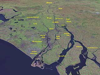
The Rhine–Meuse–Scheldt delta is a river delta in the Netherlands formed by the confluence of the Rhine, the Meuse and the Scheldt rivers. In some cases, the Scheldt delta is considered a separate delta to the Rhine–Meuse delta. The result is a multitude of islands, branches and branch names, in which a waterway that appears to be one continuous stream may have numerous separate names for different sections, e.g. Rhine → Bijlands Kanaal → Pannerdens Kanaal → Nederrijn → Lek → Nieuwe Maas → Het Scheur → Nieuwe Waterweg. Since the Rhine contributes most of the water, the term "Rhine Delta" is commonly used, although this name is also used for the delta where the Alpine Rhine flows into Lake Constance. By some calculations, the Rhine–Meuse–Scheldt delta covers 25,347 km2 (9,787 sq mi), making it the largest in Europe.
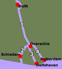
Schie the name for four waterways in the area of Overschie, South Holland, the Netherlands. There are the Delftse Schie, the Delfshavense Schie, the Rotterdamse Schie and the Schiedamse Schie. The existence of these four streams is the result of medieval rivalry among the cities of Delft, Rotterdam, and Schiedam for toll rights.

The Nieuwe Maas is a distributary of the Rhine River, and a former distributary of the Maas River, in the Dutch province of South Holland. It runs from the confluence of the rivers Noord and Lek, and flows west through Rotterdam. It ends west of the city where it meets the Oude Maas, near Vlaardingen, to form Het Scheur. After a few miles, the Scheur continues as the artificial Nieuwe Waterweg. The total length of the Nieuwe Maas is approximately 24 kilometres (15 mi).

Kleiwegkwartier is a neighbourhood quarter in Rotterdam, Netherlands. It is in the southern part of Hillegersberg with origins dating from the early 1600s.
The Scheepvaartkwartier or Nieuwe Werk is a neighborhood located on the banks of the Nieuwe Maas river in Rotterdam, the Netherlands. The Scheepvaartkwartier is among the top 20 wealthiest neighborhoods in the Netherlands. The northern boundary of the neighborhood is the Westzeedijk, to the east lies the Zalmhaven and Zalmstraat, to the south are the Willemskade, Westerkade, and Parkkade, and to the west is the Parkhaven. The Veerhaven and the nearby monumental buildings around the Parklaan, dating back to around 1900, form the heart of the Scheepvaartkwartier. The Caland Monument, dedicated to engineer Pieter Caland, is located on the Veerkade. The white, grand buildings on the Westerkade, dating back to around 1865, are among the most beautiful in the neighborhood.

The Voorne Canal is a former ship canal on Voorne-Putten in South Holland, the Netherlands. It was the first canal to connect Rotterdam to the sea. Construction of the canal started in 1826 and was completed in 1829. Until the completion of the Nieuwe Waterweg in 1872 it was the main connection from Rotterdam to the sea for ocean going ships.
![]() Media related to Rotte at Wikimedia Commons
Media related to Rotte at Wikimedia Commons