
The Rhine is one of the major European rivers, and has its sources in Switzerland and flows in a mostly northerly direction through Germany and the Netherlands, emptying into the North Sea. The river begins in the Swiss canton of Graubünden in the southeastern Swiss Alps, forms part of the Swiss-Liechtenstein, Swiss-Austrian, Swiss-German and then the Franco-German border, then flows through the German Rhineland and the Netherlands and eventually empties into the North Sea.

South Holland is a province of the Netherlands with a population of just over 3.7 million as of November 2019 and a population density of about 1,373/km2 (3,560/sq mi), making it the country's most populous province and one of the world's most densely populated areas. Situated on the North Sea in the west of the Netherlands, South Holland covers an area of 3,419 km2 (1,320 sq mi), of which 605 km2 (234 sq mi) is water. It borders North Holland to the north, Utrecht and Gelderland to the east, and North Brabant and Zeeland to the south. The provincial capital is the Dutch seat of government The Hague, while its largest city is Rotterdam. The Rhine-Meuse-Scheldt delta drains through South Holland into the North Sea. Europe's busiest seaport, the Port of Rotterdam, is located in South Holland.
Flevoland is the 12th and youngest province of the Netherlands, established in 1986, when the Southern and Eastern Flevopolders, together with the Noordoostpolder were merged into one provincial entity. It is in the centre of the country in the former Zuiderzee, which was turned into the freshwater IJsselmeer by the closure of the Afsluitdijk in 1932. Almost all of the land belonging to Flevoland was reclaimed in the 1950s and 1960s while splitting the Markermeer and Bordering lakes from the IJsselmeer. As to dry land, it is the smallest province of the Netherlands at 1,412 km2 (545 sq mi), but not gross land as that includes much of the waters of the fresh water lakes (meres) mentioned. The province has a population of 423,021 as of January 2020 and consists of six municipalities. Its capital is Lelystad and its most populous city is Almere.
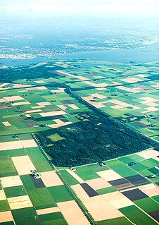
A polder is a low-lying tract of land that forms an artificial hydrological entity, enclosed by embankments known as dikes. The three types of polder are:
- Land reclaimed from a body of water, such as a lake or the seabed
- Flood plains separated from the sea or river by a dike
- Marshes separated from the surrounding water by a dike and subsequently drained; these are also known as koogs, especially in Germany

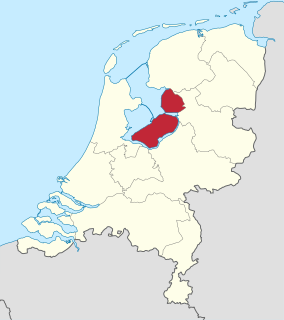
The IJsselmeer, also known as Lake IJssel in English, is a closed off inland bay in the central Netherlands bordering the provinces of Flevoland, North Holland and Friesland. It covers an area of 1,100 km2 (420 sq mi) with an average depth of 5.5 m (18 ft). The river IJssel flows into the IJsselmeer.

The geography of the European Netherlands is unusual in that much of its land has been reclaimed from the sea and is below sea level, protected by dikes. It is a small country with a total area of 41,545 km2 (16,041 sq mi) and ranked 131st. With a population of 17.4 million and density of 521/km2 (1,350/sq mi) makes it the second most densely populated member of the European Union after Malta, and the 12th most densely populated country in the world, behind only three countries with a population over 16 million. Consequently, the Netherlands is highly urbanized.

Boskoop is a town in the province of South Holland. It was a separate municipality until it merged into Alphen aan den Rijn in 2014. The town had a population of 15,050 in 2012 and covers an area of 7.29 km2 (2.81 sq mi) of which 1.39 km2 (0.54 sq mi) is water. It's the world's biggest joined floriculture area.
Capelle aan den IJssel is a town and municipality in the western Netherlands, in the province of South Holland. The municipality had a population of 66,818 in 2019, and covers an area of 15.40 km2 (5.95 sq mi), of which 1.26 km2 (0.49 sq mi) is water. It is situated on the eastern edge of Rotterdam, on the Hollandse IJssel river.

Krimpen aan den IJssel is a town and municipality in the western Netherlands, in the province of South Holland. The municipality had a population of 29,376 in 2019, and covers an area of 8.95 km2 (3.46 sq mi) of which 1.26 km2 (0.49 sq mi) is water.

Moordrecht is a town and a former municipality in the province of South Holland, the Netherlands, situated along the river Hollandse IJssel.

Nieuwerkerk aan den IJssel is a town and former municipality in the western Netherlands, in the province of South Holland. Since 2010 it is part of the new municipality of Zuidplas.

Arie Slob is a Dutch politician and history teacher serving as Minister for Primary and Secondary Education and Media in the Third Rutte cabinet since 26 October 2017.

Zuidplas is a municipality in the Netherlands located in the province of South Holland. It was established on 1 January 2010 by the joining of Moordrecht, Nieuwerkerk aan den IJssel, and Zevenhuizen-Moerkapelle. It had a population of 41,753 as of August 2017.
Prinsenland is a neighborhood of Rotterdam, Netherlands.
The Government of Rotterdam is the government of the municipality and city of Rotterdam in the Netherlands. Most of the inhabitants live in the city of Rotterdam, but the municipality also covers a number of small villages, and other parts of the local government, such as Rozenburg, cover an even larger area.
Schielands Hoge Zeedijk, formerly called Hoogendijk is a Dutch dike in the province of South Holland that stretches from the Schie at Schiedam to the Gouwe near Gouda. Constructed in the 13th century, the dike continues to protect an area inhabited by 3 million people from flooding by the North Sea.
Joël Zwarts is a Dutch footballer who plays as a forward for Excelsior.

