Hillegersberg

Last updated
Hillegersberg
Neighbourhood in the City of Rotterdam
Rotterdam-Hillegersberg, straatzicht Bergse Dorpsstraat foto7 2012-05-13 13.37.JPG
Bergse Dorpsstraat, Hillegersberg
Flag of Hillegersberg.svg
Hillegersberg wapen.svg
Rotterdamse wijken-hillegersberg.PNG
Location of Hillegersberg in Rotterdam
Coordinates: 51°57′05″N4°29′20″E / 51.95139°N 4.48889°E / 51.95139; 4.48889
Country Netherlands
Province South Holland
Municipality Rotterdam
Sub-Municipality Hillegersberg-Schiebroek
Area
  Total433 ha (1,070 acres)
Population
  Total43,991
Demonym Hillegersberger
Time zone UTC+1 (CET)
  Summer (DST) UTC+2 (CEST)
Postcode
3045, 3051–3056
Area code 010
Website www.rotterdam.nl/wonen-leven/hillegersberg-schiebroek/

Hillegersberg is a neighbourhood of Rotterdam, Netherlands. Primarily a green residential area with lakes, canals and parks, it was incorporated into the city of Rotterdam in 1941. Settlement around its Hillegonda church was first established here in 990.

Contents

History

Period drawing of the early layout and form of the Huis ten Berghe [nl] in Hillegersberg Tekening van het slot - Hillegersberg - 20112819 - RCE.jpg
Period drawing of the early layout and form of the Huis ten Berghe  [ nl ] in Hillegersberg

Hillegersberg was named after Hildegard van Vlaanderen, wife of Count Dirk II of Holland and West Friesland (920-988). The village was founded on a hill, form by a ridge of sand known locally as a donk or morre. [1] [2] Local flint finds here indicate pre-historic occupation and later discoveries of Roman pottery, medals as well as a bust of Emperor Hadrian show subsequent early activity in the area. [3]

According to legend, this ridge was formed by sand dropped from the apron of the mythical giant Hillegonda. She was said to have built her house on this ridge and so Hillegersberg, then known as Hillegonda's mountain, was named. The image of the giant Hillegonda with her torn apron is shown on Hillegersberg's coat of arms. [4] [5] A church and a castle, Huis ten Berghe  [ nl ], were subsequently built on the ridge. [6]

The castle was first mentioned in a certificate of November 2, 1269 documenting a loan from Vranke Stozep van Hildegardsberg. [7] Later in 1343, Heer Kerstant van den Berge owned the church and the castle. [8] However, in 1426, both church and castle were destroyed by the armies of Jacoba of Bavaria, during the Hoekse and Kabeljauwse quarrels. Remnants of the castle dungeon may still be found next to the Hillegondakerk in a corner of the cemetery, which dates from around 1500 in its present form. [9] The structure was designated a national monument in September 1973. [10]

Hillergersberg's Bergse-plassen lakes were created by peat extraction in its surrounding fields and their subsequent flooding between CE 1600 and 1700.

View of Hillegersberg's Straatweg in the early 1920s. The Bergse-plassen lakes lie on either side of the road. Bergse-plassen-1920.jpg
View of Hillegersberg's Straatweg in the early 1920s. The Bergse-plassen lakes lie on either side of the road.

Hillegersberg's population grew from 2,000 inhabitants in 1885 to 7,000 in 1904. The border between Hillegersberg and Rotterdam has changed several times. In 1904 and 1920 parts of Hillegersberg were annexed by Rotterdam. [11] Despite this, Hillegersberg's population would increase to 5,000 in 1920. [12] [13] In 1941, the area was absorbed completely in Rotterdam. [14] In 1979 the area became part of the sub-municipality of Hillegersberg-Schiebroek which then became a Gebied of the same name in 2014. A Gebied has an advisory commission which represents those living in the area. By January 2018, the sub-municipality of Hillegersberg-Schiebroek, of which Hillergersberg is a part, had a population of 43,991. [15] [16]

Hillegersberg's growth has been explained partly due to its attractiveness for well-to-do residents because of its lakes such as the Bergse Plassen  [ nl ], attractions like the Plaswijckpark [17] and Lommerrijk, as well as its proximity to the centre of the city. [18] [15] Hillegersberg is considered to be one of the most prosperous sub-municipalities of Rotterdam. [19] This is based on the number of expensive homes there, the quality of its amenities, and the luxury stores in its village centre. [20]

Character

Hillegersberg's Hillegondakerk as seen from the Bergse Voorplas Hillegondakerk Hillegersberg.jpg
Hillegersberg's Hillegondakerk as seen from the Bergse Voorplas

Hillegersberg has been described as a "leafy suburb (which) escaped wartime bombing, leaving its old village centre and elegant residential streets intact." [21] [22] Plaswijk and other local recreation parks were first established here in the early 1920s. [17] Hillegersberg's amenities have increased over time, with the creation for example of the Lage Bergse Bos a recreational area of 216 hectare in 1970. [23] [24] This wooded area, which lies to the North-east of Hillegersberg, is interspersed with open areas of water and grassland. A part of it is grazed by Scottish Highlander cattle. [23] [25]

The village contains (with the addition of the Nieuwe Hillegersberg development) three shopping centres: the original village itself (around the old core - Bergse Dorpsstraat, Weissenbruchlaan), and the Kleiweg and its surrounding street and the shopping center at the Van Beethovensingel. [26]

A local resident organisation InHillegersberg was established in 2015 from the Bewonersorganisatie Molenlaankwartier along with residents of Oud-Hillegersberg (old Hillegersgerberg). Its aim is to improve communications to residents and to protect the neighbourhood from negative developments. [27]

Geography

Hillegersberg (Rotterdam) looking south from the air Hillergersberg Neighbourhood (Rotterdam) from the air.jpg
Hillegersberg (Rotterdam) looking south from the air

Hillegersberg is located on the north side of the municipality of Rotterdam. It is located in an area of woods and lakes (Bergse-Plassen [ nl]), the site of two former peat excavations. [23] The Straatweg runs between these lakes, flanked by the large villas and apartment buildings. Eastern Hillegersberg is bordered by the river Rotte. However, water has presented serious problems to the residents. Many older houses suffer from foundation problems due to rotting wooden foundations, so-called ‘paalrot' [28] due to the lowering of the water table by the City authorities. [29] [30] [31]

The neighbourhood benefits from good communication links with Rotterdam International airport, four railways stations, [32] two tram lines (4 and 8), four bus lines (35, 174, B10 and B17) and the A20 Autoroute all lying in close proximity. [33]

The Sint Franciscus Gasthuis (hospital) is located on the south-western edge of Hillegersberg. [34]

Town Halls

Buitenlust Villa - was the town hall of Hillersgeberg until 1941 Buitenlust Villa C.N.A. Looslaan 1 Rotterdam.jpg
Buitenlust Villa - was the town hall of Hillersgeberg until 1941

The last town hall of Hillegersberg, prior to its annexation by Rotterdam in 1941, was the Buitenlust villa on the C.N.A. Looslaan 1. This villa was built in 1884 in the style of the neo-Renaissance by architect J.J. van Waning (1830-1917) and was commissioned by the De Kat family. [35]

This building became the town hall of the independent municipality of Hillegersberg between 1921 and 1941. After the municipality's annexation by Rotterdam, it went on to hold the offices of the city's district of Hillegersberg-Schiebroek. This site is now the location for a nursery and kindergarten as well as a wedding hall. [36]

Hillegersberg's first town hall was built in 1752. Voorgevel - Hillegersberg - 20112699 - RCE.jpg
Hillegersberg's first town hall was built in 1752.

Hillegersberg's early town hall may be seen at 10 Kerkstraat in the area's old village centre. It was built in 1752 and is now serves as a location for a restaurant. [37] [38]

Both buildings have been designated as national monuments. [35] [37]

Education

Nord Anglia International School of Rotterdam American International School of Rotterdam (4).JPG
Nord Anglia International School of Rotterdam

Hillegersberg has twelve schools covering different ages and educational levels as specified and accredited by the Dutch education system. [25]

The American International School of Rotterdam (AISR) was established in the area in 1959. [39] [40] In 2020, AISR became Nord Anglia International School Rotterdam. [41] [42]

The Japanese School of Rotterdam, a Japanese international day school, was also set up here in 1996. [43] [44] The Hague-Rotterdam Japanese Saturday School (ハーグ・ロッテルダム日本語補習授業校 Hāgu Rotterudamu Nihongo Hoshū Jugyō Kō ), a Japanese Saturday school was also formed here in 1996 by the merger of existing Saturday schools in The Hague and Rotterdam, [45] holds its classes at the Rotterdam Japanese day school. [46] [45]

Residents

Further reading

H. Snellen-Balendong (1993) Gebouwd in de wijk: Monumenten en andere historische gebouwen in Hillgersberg - Schiebroek - Terbregge ISBN 90-70873-01-X

Related Research Articles

<span class="mw-page-title-main">Transport in the Netherlands</span> Overview of the transport in the Netherlands

The Netherlands is both a very densely populated and a highly developed country in which transport is a key factor of the economy. Correspondingly it has a very dense and modern infrastructure, facilitating transport with road, rail, air and water networks. In its Global Competitiveness Report for 2014-2015, the World Economic Forum ranked the Dutch transport infrastructure fourth in the world.

<span class="mw-page-title-main">Rotterdam</span> City in South Holland, Netherlands

Rotterdam is the second-largest city in the Netherlands after the national capital of Amsterdam. It is in the province of South Holland, part of the North Sea mouth of the Rhine–Meuse–Scheldt delta, via the "New Meuse" inland shipping channel, dug to connect to the Meuse at first and now to the Rhine.

<span class="mw-page-title-main">The Hague</span> City and municipality in South Holland, Netherlands

The Hague is a city and municipality of the Netherlands, situated on the west coast facing the North Sea. The Hague is the capital of the province of South Holland. The Hague is the country's administrative centre and its seat of government, and while the official capital of the Netherlands is Amsterdam, The Hague has been described as the country's de facto capital.

<span class="mw-page-title-main">Gouda, South Holland</span> City and municipality in South Holland, Netherlands

Gouda is a city and municipality in the west of the Netherlands, between Rotterdam and Utrecht, in the province of South Holland. Gouda has a population of 75,000 and is famous for its Gouda cheese, stroopwafels, many grachten, smoking pipes, and its 15th-century city hall. Its array of historic churches and other buildings makes it a very popular day-trip destination.

<span class="mw-page-title-main">Wassenaar</span> Municipality and town in South Holland, Netherlands

Wassenaar is a municipality and town located in the province of South Holland, on the western coast of the Netherlands.

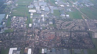
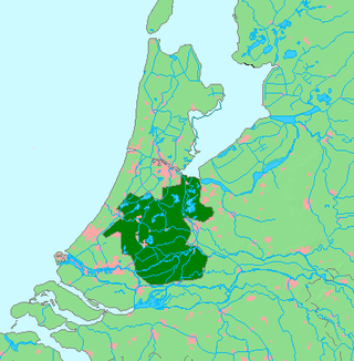
The Randstad is a roughly crescent- or arc-shaped conurbation in the Netherlands, that houses almost half the country's population. With a central-western location, it connects and comprises the Netherlands' four biggest cities, their suburbs, and many towns in between, that all grew and merged into each other. Among other things, it includes the Port of Rotterdam, the Port of Amsterdam, and Amsterdam Airport Schiphol. With a population of approximately 8.4 million people it is one of the largest metropolitan regions in Europe, comparable in population size to the Rhine-Ruhr metropolitan region or the San Francisco Bay Area, and covers an area of approximately 11,372 km2 (4,391 sq mi). The Randstad had a gross regional product of €397 billion in 2017, making it the third most productive region in the European Union, behind the Paris metropolitan area and the Rhine-Ruhr metropolitan region. It encompasses both the Amsterdam metropolitan area and Rotterdam–The Hague metropolitan area. It is part of the larger Blue Banana megalopolis.

<span class="mw-page-title-main">Pijnacker</span> Place in South Holland, Netherlands

Pijnacker is a town in the Dutch province of South Holland. It is bordered Zoetermeer to the north, by Nootdorp to the northwest, by Delfgauw to the southwest, by Rotterdam to the south and by Berkel en Rodenrijs to the east.

<span class="mw-page-title-main">Groene Hart</span> Area of the Netherlands

The Groene Hart is a relatively thinly populated area of the Netherlands covering much of the middle portion of the Randstad megalopolis. The major Dutch cities of Rotterdam, The Hague, Leiden, Haarlem, Amsterdam and Utrecht surround this area. Cities inside the Groene Hart include Zoetermeer, Alphen aan den Rijn, Gouda, Woerden and the smaller cities of Schoonhoven, Oudewater, Haastrecht, Nieuwkoop, Montfoort, Waddinxveen, Bodegraven and Boskoop.

<span class="mw-page-title-main">110-Morgen</span> Neighborhood in Rotterdam, South Holland, Netherlands

110-Morgen is a neighborhood in Rotterdam, Netherlands Located in Hillegersberg-Schiebroek. The name refers to a polder of the same name from 1772, with a surface area of 110 morgen.

<span class="mw-page-title-main">Kleiwegkwartier</span> Neighborhood of Rotterdam in South Holland, Netherlands

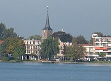
Kleiwegkwartier is a neighbourhood quarter in Rotterdam, Netherlands. It is in the southern part of Hillegersberg with origins dating from the early 1600s.

<span class="mw-page-title-main">Government of Rotterdam</span>

The Government of Rotterdam is the government of the municipality and city of Rotterdam in the Netherlands. Most of the inhabitants live in the city of Rotterdam, but the municipality also covers a number of small villages, and other parts of the local government, such as Rozenburg, cover an even larger area.

The following is a timeline of the history of the municipality of Rotterdam, Netherlands.

<span class="mw-page-title-main">Nord Anglia International School Rotterdam</span> Private school, international school in Rotterdam, Netherlands

Nord Anglia International School Rotterdam (NAISR) is an International school in Hillegersberg, Netherlands, an area of Rotterdam. The school educates students from 3–18 years of age and has three academic areas: Early Years, Primary School and Secondary School.

<span class="mw-page-title-main">Japanese School of Rotterdam</span> Japanese international school in Netherlands

The Japanese School of Rotterdam is a Japanese international school in Hillegersberg, Rotterdam.

<span class="mw-page-title-main">Stichting William K. Gordon Scholarship Fund</span>

The William K. Gordon Scholarship Fund is a Dutch Foundation set up in the early 1970s to promote international education in Rotterdam, the Netherlands.

<span class="mw-page-title-main">Rotte, Lansingerland</span> Vicinity in South Holland, Netherlands

Rotte is a vicinity in the municipality of Lansingerland, in the province of South Holland, Netherlands. It used to be part of the former municipality of Bergschenhoek and is located opposite Rotterdam Ommoord.

Valkenbos, also written as Valkenbosch, was a 18th-century fluyt of the Dutch East India Company.

<span class="mw-page-title-main">St Hildegard's Church, Rotterdam</span> Church in Rotterdam, Netherlands

St Hildegard's Church is a Roman Catholic church in the Oude Noorden in Rotterdam, Netherlands.

References

  1. It is created from sprayed sand from dry riverbeds formed in the late ice age.
  2. A donk is a swamp, low-lying area of land that is saturated with water and unfit for agricultural purposes, marsh, bog
  3. rik (2013-12-16). "Excerpta Romana. De bronnen der Romeinsche Geschiedenis van Nederland". resources.huygens.knaw.nl (in Dutch). Retrieved 2018-06-16.
  4. "Het ontstaan van Hillegersberg - Stichting Histories Hillegersberg". www.stichtinghistorieshillegersberg.nl (in Dutch). Retrieved 2018-06-16.
  5. This event is depicted on the coat of arms of Hillegersberg
  6. "COLLECTIE ROTTERDAM - Laatmiddeleeuws kasteel Hillegersberg". www.rotterdaminkaart.nl. Retrieved 2018-06-16.
  7. Van Hildegardsbergin also appears in the lists of parishes where 1270 tithes were shown to have been levied to finance the crusades.
  8. According to various documents, Willem van Hildegaersberch was born here. W. van Hildegaersberch (c.1350 - c. 1408) is regarded as the first medieval 'fairy-tale speaker' of the Netherlands.
  9. "Het dorp Hillegersberg". De website van vriendenvandehillegondake! (in Dutch). Retrieved 2018-06-16.
  10. "32897 Bij Kerkstraat 43 3054 NB te Rotterdam". Rijksdienst voor het Cultureel Erfgoed (in Dutch). 2017-12-08. Retrieved 2018-06-16.
  11. The border between Rotterdam and Hillegersberg was originally at the end of the Bergweg; large parts of the current Oude Noorden in Rotterdam also originally belonged to Hillegersberg.
  12. Tweede Kamer, (1902-1903) Wijziging van de grens tusschen de gemeenten Rotterdam en Hillegersberg.
  13. "Bevolkingscijfers van Rotterdam vanaf 1868 | Stadsarchief Rotterdam". www.stadsarchief.rotterdam.nl (in Dutch). Retrieved 2018-06-16.
  14. The last mayor of Hillegersberg was Frederik Hendrik van Kempen (1879-1966). Just before the annexation by Rotterdam in 1941, a street in Hillegersberg was named after him. Just like Adrianus Johannes Breedveld (1873-1962), he had been a municipal councilor since 1918 and was alderman from 1919-1931, Maarten Dijkshoorn (1848-1930) who had been a councilor of Hillegersberg from 1887-1927 and was also alderman, and Johannes van Ballegooij (1889-1970), from 1925 until the end in 1941, municipal secretary of Hillegersberg.
  15. 1 2 "Feitenkaart, Bevolkingsmonitor januari 2018 (Gemeente Rotterdam) | nvdemografie.nl". nvdemografie.nl (in Dutch). Retrieved 2018-06-16.
  16. In 2018 Hillergersberg residents statistics could be divided as follows: 20% between 0 and 14 years, 10% between 15 and 24 years, 25% between 25 and 44 years, 26% between 45 and 64 years, and 19% are 65 years or older. 34% of people are married and 52% are unmarried. The neighbourhood had a total of 20,100 households - which consisted of 42% single households, 24% double households and 35% households with one or more children. On average, a household consists of 2.2 people. (www.cbs.nl)
  17. 1 2 "Over Plaswijckpark - Plaswijckpark". Plaswijckpark (in Dutch). Retrieved 2018-06-16.
  18. "Bergse Plassen | Stadsarchief Rotterdam". www.stadsarchief.rotterdam.nl (in Dutch). Retrieved 2018-06-16.
  19. Netherlands, Statistics. "Society". www.cbs.nl. Retrieved 2018-06-16.
  20. "Hillegersberg | Stadsarchief Rotterdam". stadsarchief.rotterdam.nl (in Dutch). Retrieved 2018-06-16.
  21. "Where to live in Rotterdam". www.expatica.com. 2016. Retrieved 2018-06-20.
  22. Information, Rotterdam Tourist. "Hilligersberg-Schiebroek | Rotterdam Tourist Information". Rotterdam Tourist Information. Retrieved 2018-06-20.
  23. 1 2 3 Peat extraction here began in the 1500s. "Lage Bergse Bos | IVN". www.ivn.nl (in Dutch). Retrieved 2018-06-16.{{cite web}}: CS1 maint: numeric names: authors list (link)
  24. "Lage Bergse Bos | Stadsarchief Rotterdam". www.stadsarchief.rotterdam.nl (in Dutch). Retrieved 2018-06-16.
  25. 1 2 Gazaleh-Weevers, Sheila; Agudo, Shirley; Moser, Connie (June 2007). Here's Holland. Eburon Uitgeverij B.V. ISBN   9789059721418.
  26. Carponen, Claire. "A Former Village, Rotterdam's Hillegersberg Neighborhood Offers Outdoor Pursuits". www.mansionglobal.com. Retrieved 2020-01-28.
  27. "InHillegersberg - Home". inhillegersberg.nl (in Dutch). Retrieved 2018-08-07.
  28. Hillegersberg-Schiebroek | Rotterdam.nl, Gemeente Rotterdam (2014). "OUD HILLEGERSBERG MAATREGELEN TEGEN PAALROT" (PDF). Gemeente Rotterdam (in Dutch). Retrieved 2018-06-24.
  29. "Problemen herkennen | paalrot.info". www.paalrot.info (in Dutch). Retrieved 2018-06-16.
  30. "InHillegersberg - Grondwater". inhillegersberg.nl (in Dutch). Retrieved 2018-06-17.
  31. "InHillegersberg - Historisch onderzoek naar de oorzaken van de grondwaterstandsdaling". inhillegersberg.nl (in Dutch). Retrieved 2018-08-07.
  32. Ansonika. "Train Service to Rotterdam". City Guide Rotterdam. Retrieved 2018-06-20.
  33. RET NV. "Discover greater Rotterdam with public transport". www.ret.nl. Archived from the original on 2017-08-03. Retrieved 2018-06-18.
  34. "Franciscus Gasthuis&Vlietland, zorg van generaties - Franciscus Gasthuis & Vlietland". www.franciscus.nl (in Dutch). Retrieved 2018-06-18.
  35. 1 2 "527203 C.N.A.Looslaan 1 3054 BN te Rotterdam". Rijksdienst voor het Cultureel Erfgoed (in Dutch). 2017-12-07. Retrieved 2018-06-22.
  36. "Kindergarden Straatweg". Kindergarden.nl. Archived from the original on 6 December 2021. Retrieved 1 September 2018.
  37. 1 2 "32901 Kerkstraat 10 3054 NC te Rotterdam". Rijksdienst voor het Cultureel Erfgoed (in Dutch). 2017-12-08. Retrieved 2018-06-22.
  38. "Restaurant 't Ambachthuys". Restaurant 't Ambachthuys Hillegersberg (in Dutch). Retrieved 2018-09-01.
  39. "List of international schools in the Netherlands" . Retrieved 2018-06-16.
  40. "American International School of Rotterdam - International School for Rotterdam and The Hague | The American International School of Rotterdam (AISR) - Early Learning (Kindergarten), Elementary, Middle and Secondary High School". www.aisr.nl. Retrieved 2018-06-16.
  41. "Nord Anglia - a new premium international school concept in Rotterdam". DutchNews.nl. 28 January 2020. Retrieved 2020-01-28.
  42. "Rotterdam | Schools Netherlands | Nord Anglia Education". www.nordangliaeducation.com. Retrieved 2020-01-28.
  43. "List of international schools in the Netherlands".
  44. "ロッテルダム日本人学校". www.jsrotte.nl (in Japanese). Retrieved 2018-06-16.
  45. 1 2 "Introduction" (Archive). The Hague-Rotterdam Japanese Saturday School. Retrieved on April 5, 2015. Dutch version (Archive). Japanese version (Archive).
  46. "Home." The Hague-Rotterdam Japanese Saturday School. Retrieved on February 15, 2015. "Verhulstlaan 19 3055WJ Rotterdam The Netherlands"