
Oude Noorden is an area of north Rotterdam, Netherlands and is part of the borough Noord. It has approximately 18,000 inhabitants. The district has much pre World War I and World War II architecture still in existence. It has a vibrant though somewhat discreet artistic community.

Darayim is a district in Badakhshan Province, Afghanistan. It was created in 2005 from part of Fayzabad District and is home to approximately 65,000 residents.
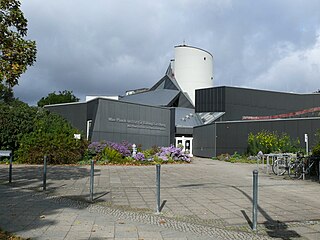
The Max-Planck-Institute for Human Development is an internationally renowned social science research organization. Located in Berlin, it was initiated in 1961 and officially began operations in 1963 under the name Institute for Educational Research in the Max Planck Society, before receiving its current name in 1971. Its co-founder and first director was Hellmut Becker. The institute is part of the Human Sciences Section of the Max Planck Society.

Marcinów is a village in the administrative district of Gmina Abramów, within Lubartów County, Lublin Voivodeship, in eastern Poland. It lies approximately 3 kilometres (2 mi) north-west of Abramów, 22 km (14 mi) west of Lubartów, and 32 km (20 mi) north-west of the regional capital Lublin.
Jakubowo-Węgielin is a village in the administrative district of Gmina Przemków, within Polkowice County, Lower Silesian Voivodeship, in south-western Poland. Prior to 1945 it was in Germany.
Heikant is a hamlet in the municipality of Sint Anthonis, in the Dutch province of North Brabant. It is located about 2 km south of Oploo.
Kolechowice Pierwsze is a village in the administrative district of Gmina Ostrów Lubelski, within Lubartów County, Lublin Voivodeship, in eastern Poland.
Nowa Wieś is a village in the administrative district of Gmina Poddębice, within Poddębice County, Łódź Voivodeship, in central Poland. It lies approximately 7 kilometres (4 mi) west of Poddębice and 43 km (27 mi) west of the regional capital Łódź.
Kuźnica Zagrzebska is a village in the administrative district of Gmina Klonowa, within Sieradz County, Łódź Voivodeship, in central Poland. It lies approximately 6 kilometres (4 mi) north of Klonowa, 30 km (19 mi) south-west of Sieradz, and 83 km (52 mi) south-west of the regional capital Łódź.
Byczki is a village in the administrative district of Gmina Godzianów, within Skierniewice County, Łódź Voivodeship, in central Poland. It lies approximately 3 kilometres (2 mi) south of Godzianów, 12 km (7 mi) south-west of Skierniewice, and 41 km (25 mi) east of the regional capital Łódź.
Michałowice is a village in the administrative district of Gmina Kowiesy, within Skierniewice County, Łódź Voivodeship, in central Poland. It lies approximately 4 kilometres (2 mi) south-east of Kowiesy, 24 km (15 mi) east of Skierniewice, and 70 km (43 mi) east of the regional capital Łódź.

Al-A'amiriya is a neighborhood in the Mansour district of western Baghdad, Iraq, on the way to Anbar Province. The name is also written Amariya, Amariyah, Ameria, Ameriya, Amerya, Amiriya and Amiriyah.
Działki Suskowolskie is a village in the administrative district of Gmina Pionki, within Radom County, Masovian Voivodeship, in east-central Poland.
Poświętne is a village in the administrative district of Gmina Pionki, within Radom County, Masovian Voivodeship, in east-central Poland. It lies approximately 7 kilometres (4 mi) west of Pionki, 16 km (10 mi) north-east of Radom, and 87 km (54 mi) south of Warsaw.
Klonowice is a village in the administrative district of Gmina Czersk, within Chojnice County, Pomeranian Voivodeship, in northern Poland. It lies approximately 11 kilometres (7 mi) north-east of Czersk, 39 km (24 mi) north-east of Chojnice, and 67 km (42 mi) south-west of the regional capital Gdańsk.
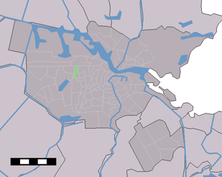
Kolenkit District is a neighbourhood in Amsterdam, Netherlands.

Bloemhof is a neighborhood in Rotterdam, Netherlands.

Giurgiului is a neighborhood in the southern part of the Romanian capital Bucharest, near Berceni and Ferentari. Like Berceni, Giurgiului has plenty of 10-storey blocks of flats that were built under Communist rule starting with 1959-1964. The estimated population is between 30,000 and 40,000. Before the Communists started their massive building programme, Giurgiului was a farming village. After 1948 the village was added to the city area. A few years later in the south of the neighborhood a pipe factory was built along with a power plant, CET Berceni.

Provenierswijk is a neighborhood of Rotterdam, Netherlands.
El Brazil is a census-designated place (CDP) in Starr County, Texas, United States. This was a new CDP for the 2010 census with a population of 47.


