Overschie

Last updated
Overschie (light green) within Rotterdam (purple). Rotterdamse wijken-stadsdeel overschie.PNG
Overschie (light green) within Rotterdam (purple).

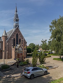
Overschie is a neighborhood of Rotterdam, Netherlands, formerly a separate village with its own municipality.

Rotterdam Municipality in South Holland, Netherlands

Rotterdam is the second-largest city and a municipality of the Netherlands. It is located in the province of South Holland, at the mouth of the Nieuwe Maas channel leading into the Rhine–Meuse–Scheldt delta at the North Sea. Its history goes back to 1270, when a dam was constructed in the Rotte, after which people settled around it for safety. In 1340, Rotterdam was granted city rights by the Count of Holland.

Netherlands Constituent country of the Kingdom of the Netherlands in Europe

The Netherlands is a country located mainly in Northwestern Europe. The European portion of the Netherlands consists of twelve separate provinces that border Germany to the east, Belgium to the south, and the North Sea to the northwest, with maritime borders in the North Sea with Belgium, Germany and the United Kingdom. Together with three island territories in the Caribbean Sea—Bonaire, Sint Eustatius and Saba— it forms a constituent country of the Kingdom of the Netherlands. The official language is Dutch, but a secondary official language in the province of Friesland is West Frisian.

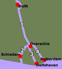
The village of Overschie was located on the intersection of four rivers called "Schie": the Delftsche Schie, Schiedamsche Schie, Delfshavensche Schie, and Rotterdamsche Schie. It was a separate municipality between 1817 and 1941, when it merged with Rotterdam. [1] Immediately after the Second World War, the construction of a large suburb was begun southeast of the village.

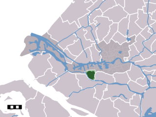
"Overschie" is now also the name of a deelgemeente (borough) of the city of Rotterdam, covering the former village, the neighborhood Overschie, airport Zestienhoven, and the countryside to the north including the hamlet Zweth.

Rotterdam The Hague Airport airport serving the cities of Rotterdam and The Hague, located in Rotterdam

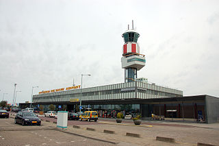
Rotterdam The Hague Airport, located 3 NM north northwest of Rotterdam, is the Netherlands' third largest airport. It serves the city of Rotterdam as well as The Hague and surroundings. The airport handled over 1.6 million passengers in 2016 and features scheduled flights to European metropolitan and leisure destinations. It is also used extensively by general aviation and there are several flying clubs and schools located at the airport.

Zweth Place in South Holland, Netherlands

Zweth or De Zweth is a hamlet in the western Netherlands. It is located about halfway between Delft and Rotterdam, where the small river Berkelsche Zweth joins the Schie river, around a bridge across the Berkelsche Zweth.

Church of the village Overschie Overschie kerk.png
Church of the village Overschie
Overschie in 1867. Overschie 1867.png
Overschie in 1867.

Related Research Articles

Pernis, Netherlands Place in South Holland, Netherlands

Pernis is a neighborhood and submunicipality of Rotterdam, Netherlands. The district has a population of 4,789 (2011) on a total area size of 1.60 km². Pernis is thus a full submunicipality of Rotterdam, but the former independent municipality had its own district council already. Although surrounded by ports, Pernis has preserved its village-like atmosphere very well.

Rhoon village that borders the municipality of the city of Rotterdam, Netherlands

Rhoon is a village that borders the municipality of the city of Rotterdam, South Holland, the Netherlands.

Hoogvliet Place in Zuid-Holland, Netherlands

Hoogvliet is a borough of Rotterdam, Netherlands. As of 1 January 2004, it had 36,619 inhabitants. There is also a national chain of Dutch supermarkets with the same name.

Tienhoven aan de Lek Place in Utrecht, Netherlands

Tienhoven is a village in the Dutch province of Utrecht. It is a part of the municipality of Vijfheerenlanden, and lies about 10 km southwest of IJsselstein.

Kesteren Place in Gelderland, Netherlands

Kesteren is a town in the Dutch province of Gelderland. It is a part of the municipality of Neder-Betuwe, and lies about 8 km southwest of Wageningen.

Huijbergen Place in Netherlands, Kingdom of the Netherlands

Huijbergen is a village in the Dutch province of North Brabant. It is located in the municipality of Woensdrecht, about 9 kilometres (5.6 mi) southeast of Bergen op Zoom, close to the Belgian border.

Charlois quarter and former borough of Rotterdam

Charlois is a neighbourhood of the Dutch city of Rotterdam. It is located on the south bank of the Meuse River.

IJsselmonde is a former village in the Dutch province of South Holland. It was located to the east of the city of Rotterdam. The village derives its name from the river Hollandsche IJssel, which flows into the Nieuwe Maas opposite from the village. The village gives its name to the large island it's on, IJsselmonde.

Katendrecht is a former village in the Dutch province of South Holland. It is now a neighbourhood of Rotterdam, on the south bank of the Nieuwe Maas.

Kralingen Place in South Holland, Netherlands

Kralingen is a former village in the Dutch province of South Holland, now a neighbourhood of Rotterdam. It is located about 3 kilometres east of the city centre, in the borough Kralingen-Crooswijk.

Schiebroek neighbourhood of Rotterdam, The Netherlands

Schiebroek is a former village in the Dutch province of South Holland. It is now a neighbourhood of Rotterdam, and part of the borough of Hillegersberg-Schiebroek.

Tempel, also known as De Tempel, is a former municipality and former manorial estate in the Dutch province of South Holland. It was located about 3 km southwest of the center of the current village of Berkel en Rodenrijs.

Schie river in the Netherlands

Schie is the name for four waterways in the area of Overschie, South Holland, the Netherlands. There are the Delftse Schie, the Delfshavense Schie, the Rotterdamse Schie and the Schiedamse Schie. The existence of these four streams is the result of medieval rivalry among the cities of Delft, Rotterdam, and Schiedam for toll rights.

Blijdorp district Neighbourhood of Rotterdam in Rotterdam, South Holland, Netherlands

Blijdorp is a neighbourhood in northern Rotterdam and is part of the borough Noord. The neighbourhood has around 9500 inhabitants.

Kleiwegkwartier Neighborhood of Rotterdam in South Holland, Netherlands

Kleiwegkwartier is a neighbourhood quarter in Rotterdam, Netherlands. It is in the southern part of Hillegersberg with origins dating from the early 1600s.

Spangen Neighborhood of Rotterdam in South Holland, Netherlands

Spangen is a neighborhood of Rotterdam, Netherlands.

The Government of Rotterdam is the government of the municipality and city of Rotterdam in the Netherlands. Most of the inhabitants live in the city of Rotterdam, but the municipality also covers a number of small villages, and other parts of the local government, such as Rozenburg, cover an even larger area.

Noord, Rotterdam Place in South Holland, Netherlands

Noord is a borough of Rotterdam. The municipal portion is formed by the Delfshavense Schie, the Highway 20 (A20), the Rotte and the rails. The borough had 51,796 inhabitants in 2017.

Zestienhoven (district) Neighborhood of Rotterdam in Rotterdam, South Holland, Netherlands

Zestienhoven is a neighborhood of Rotterdam, Netherlands and is part of the borough Overschie. Zestienhoven is the largest district in Overschie, but is sparsely populated. The Polder Zestienhoven is within the district, east of the urban area of Overschie. On the east side is the neighborhood Schiebroek and on the north side Rotterdam The Hague Airport.

References

  1. Ad van der Meer and Onno Boonstra, Repertorium van Nederlandse gemeenten , KNAW, 2006.


Coordinates: 51°56′N4°26′E / 51.933°N 4.433°E / 51.933; 4.433

Geographic coordinate system Coordinate system

A geographic coordinate system is a coordinate system that enables every location on Earth to be specified by a set of numbers, letters or symbols. The coordinates are often chosen such that one of the numbers represents a vertical position and two or three of the numbers represent a horizontal position; alternatively, a geographic position may be expressed in a combined three-dimensional Cartesian vector. A common choice of coordinates is latitude, longitude and elevation. To specify a location on a plane requires a map projection.