
The geography of France consists of a terrain that is mostly flat plains or gently rolling hills in the north and west and mountainous in the south and the east. Metropolitan France has a total size of 551,695 km2 (213,011 sq mi). It is the third largest country in Europe after Russia and Ukraine.
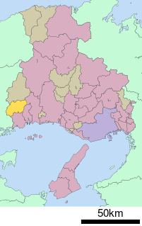
Akō is a district located in Hyōgo Prefecture, Japan.
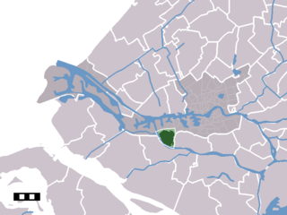
Hoogvliet is a borough of Rotterdam, Netherlands. As of 1 January 2004, it had 36,619 inhabitants. There is also a national chain of Dutch supermarkets with the same name.

The Molucca Sea is located in the western Pacific Ocean, around the vicinity of Indonesia, specifically bordered by the Indonesian Islands of Celebes (Sulawesi) to the west, Halmahera to the east, and the Sula Islands to the south. The Molucca Sea has a total surface area of 77,000 square miles. The Molucca Sea is rich in coral and has many diving sites due to the deepness of its waters. The deepness of the water explains the reasoning behind dividing the sea into three zones, which functions to transport water from the Pacific Ocean to the shallower seas surrounding it. The deepest hollow in the Molucca Sea is the 15,780-foot (4,810-meter) Batjan basin. This region is known for its periodic experiences of earthquakes, which stems from the sea itself being a micro plate, in which the Molucca Sea is being subducted in two opposite directions: one in the direction of the Eurasian Plate to the west and the other in the direction of the Philippines Sea Plate to the east.

Sulejów Abbey was a Cistercian abbey founded in 1176 by the duke Kazimierz II the Just. The town of Sulejów grew up round it.
Bota is a mukim in Perak Tengah District, Perak, Malaysia. It comprises two geographical areas: Bota Kiri and Bota Kanan as it is divided by the Perak River. There is a river terrapin breeding centre at Bota Kanan. Bota is also well known for its durian fruit. The town has over fifteen mosques.
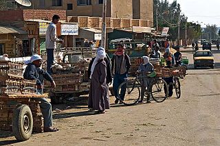
El-Bawiti is a town in the Western desert in Egypt. With 30,000 inhabitants, it is the largest settlement in the Bahariya Oasis.
Harz is a district in Saxony-Anhalt, Germany.

Ledigos is a municipality located in the province of Palencia, Castile and León, Spain. According to the 2004 census (INE), the municipality has a population of 96 inhabitants.

Józefów is a village in the administrative district of Gmina Zgierz, within Zgierz County, Łódź Voivodeship, in central Poland. It lies approximately 7 kilometres (4 mi) east of Zgierz and 10 km (6 mi) north of the regional capital Łódź.
This is a list of the extreme points and extreme elevations in Wales.
Huby is a village in the administrative district of Gmina Kłomnice, within Częstochowa County, Silesian Voivodeship, in southern Poland. It lies approximately 7 kilometres (4 mi) south of Kłomnice, 18 km (11 mi) north-east of Częstochowa, and 73 km (45 mi) north of the regional capital Katowice.
Ramachandrapura is a small village and neighbourhood located in the outskirts of India's fifth-largest metropolitan area, Bangalore. It is accessible through Doddabommasandra and Jalahalli and Main Ramachandrapura Mutt was located in Hosanagar Shivamogga Dist. Many Indian cattle are present and they nursed well. Google Maps [[13.8652734, 75.0757448 ]].Ramachandrapura Karnataka 577418 https://www.google.com/maps/place/Ramachandrapura,+Karnataka+577418/@13.8701551,75.0794001,13z/data=!4m2!3m1!1s0x3bbb83cb6f51aaab:0x3234a01eb72ffed[[https://maps.app.goo.gl/YmDW9wQBV2wRPnPY6]]
Boriki is a village in Gabrovo Municipality, in Gabrovo Province, in northern central Bulgaria.
Stoykovtsi is a village in Gabrovo Municipality, in Gabrovo Province, in northern central Bulgaria.

Vrba is a village in the municipality of Tutin, Serbia. According to the 2002 census, the village has a population of 196 people.
Udarny, Udarnaya, or Udarnoye is the name of several inhabited localities in Russia.

The Baltistan Division is a first-order administrative division of Pakistan's dependent territory of Gilgit-Baltistan.

Said Sadiq is a city in the Sulaymaniyah Governorate of Iraq. The nearby archaeological site of Tell Begum shows that the area was already occupied in the Late Halaf period.
This page is based on this
Wikipedia article Text is available under the
CC BY-SA 4.0 license; additional terms may apply.
Images, videos and audio are available under their respective licenses.