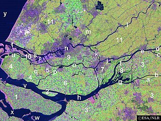
Rotterdam is the second-largest city in the Netherlands after the national capital of Amsterdam. It is in the province of South Holland, part of the North Sea mouth of the Rhine–Meuse–Scheldt delta, via the "New Meuse" inland shipping channel, dug to connect to the Meuse at first and now to the Rhine.

Rosmalen is a town in the province of North Brabant, in the south of the Netherlands. The town is located 6 kilometers east of the city of 's-Hertogenbosch and has been part of that municipality since 1996. Its population is around 37,240 on 1 January 2021. In 2005 the town began construction of a new neighbourhood, De Groote Wielen, to include 5,000 homes and other buildings.

The Waal is the main distributary branch of the river Rhine flowing approximately 80 km (50 mi) through the Netherlands. It is the major waterway connecting the port of Rotterdam to Germany. Before it reaches Rotterdam, it joins with the Afgedamde Maas near Woudrichem to form the Boven Merwede. Along its length, Nijmegen, Tiel, Zaltbommel and Gorinchem are towns of importance with direct access to the river.

IJsselmonde is a river island in the Netherlands, between the Nieuwe Maas, Noord and Oude Maas branches rivers of the Rhine-Meuse delta in the province of South Holland. The city of Rotterdam now occupies most of the northern part of the island and includes the eponymous former village of IJsselmonde, once a separate community. The island was once a rich agricultural region but is mostly suburbs today. Only the mid-south parts of the island have retained their agricultural character.

Oude Noorden is an area of north Rotterdam, Netherlands and is part of the borough Noord. It has approximately 18,000 inhabitants. The district has much pre World War I and World War II architecture still in existence. It has a vibrant though somewhat discreet artistic community.

Erasmus University Medical Center based in Rotterdam, Netherlands, affiliated with Erasmus University and home to its faculty of medicine, is the largest and one of the most authoritative scientific university medical centers in Europe. The hospital is the largest of the eight university medical centers in the Netherlands, both in terms of turnover and number of beds. The Erasmus MC ranks #1 among the top European institution in clinical medicine and #20 in the world, according to the Times Higher Education rankings.

Katendrecht is a neighbourhood of Rotterdam, on the south bank of the Nieuwe Maas. It is located between the Rijnhaven and the Maashaven. Katendrecht was a separate municipality from 1817 to 1874, when it merged with Charlois.

Olli is a Dutch children's book character and a stuffed toy. The character Olli was created in 2004 by Dutch designer and film director Hein Mevissen along with writer Diederiekje Bok as a character for a bottled mineral water. Olli was one of the many characters used on the packages and posters of the bottled water brand and John's Phone. Olli was launched at a party of MTV In Rotterdam in 2004. In 2013, Olli was again part of a campaign, this time to save the Rotterdam Zoo Diergaarde Blijdorp. Olli is part of the Ollimania family which is the company that created and owns all characters. After the launch, Olli became the symbol of Rotterdam and a mascot for professional football club Feyenoord. On 10 September 2015, Ollimania and its creators Hein Mevissen and Diederiekje Bok donated a huge Olli statue to the Sophia children's hospital in Rotterdam.

Melanchthonweg is a metro station, as a part of the Rotterdam metro and the regional light rail system RandstadRail, located in Rotterdam, the Netherlands.
Buikslotermeer is a neighborhood and a polder of Amsterdam, Netherlands. The Buikslotermeer is a reclaimed lake, now largely located within the city of Amsterdam-Noord. Nowadays, the name 'Buikslotermeer' is used to refer to the entire Buikslotermeerpolder of the similarly named neighborhood, located in the south-east of the polder.

Blijdorp is a neighbourhood in northern Rotterdam and is part of the borough Noord. The neighbourhood has around 9500 inhabitants.

Agniesebuurt is a neighborhood in Rotterdam, Netherlands in Rotterdam-Noord.

Crooswijk is a neighborhood of Rotterdam, Netherlands. Crooswijk lies between the districts Kralingen, Oude Noorden and Centrum. Crooswijk was once known for its Marines barracks. Many streets bear witness to a military history of the Marine Corps: Tamboerstraat, Pijperstraat, Schuttersveld, Excercitiestraat, Vaandrigstraat. Crooswijk also has an industrial past. Jamin, Heineken Brewery and many abattoirs were established there. These industries have given way to housing. On the Crooswijksesingel is only the monumental building of Heineken still standing. Crooswijk is one of the original people's neighborhoods of Rotterdam and the district is strongly associated with the 'real' Rotterdammer. The Crooswijk is sometimes called: "The poorest part of the Netherlands", or: "The poorest part of Rotterdam". This is because the average income of the people living there is lower than other places.

Kleiwegkwartier is a neighbourhood quarter in Rotterdam, Netherlands. It is in the southern part of Hillegersberg with origins dating from the early 1600s.

Noordereiland is a neighborhood of Rotterdam, Netherlands. The Noordereiland owes its name to the Noorderhaven which, under the leadership of C.B. van der Tak was dug between 1872 and 1874. By digging the Noorderhaven, the Noordereiland was separated from the former island of Fijenoord and is now an island between the central parts of the North and South side of the city. Until the end of the 20th century the island was inhabited by a large population of inland skippers. Part of the neighborhood is a protected cityscape.
The Scheepvaartkwartier or Nieuwe Werk is a neighborhood located on the banks of the Nieuwe Maas river in Rotterdam, the Netherlands. The Scheepvaartkwartier is among the top 20 wealthiest neighborhoods in the Netherlands. The northern boundary of the neighborhood is the Westzeedijk, to the east lies the Zalmhaven and Zalmstraat, to the south are the Willemskade, Westerkade, and Parkkade, and to the west is the Parkhaven. The Veerhaven and the nearby monumental buildings around the Parklaan, dating back to around 1900, form the heart of the Scheepvaartkwartier. The Caland Monument, dedicated to engineer Pieter Caland, is located on the Veerkade. The white, grand buildings on the Westerkade, dating back to around 1865, are among the most beautiful in the neighborhood.
Terbregge is a neighborhood of Rotterdam, Netherlands.

Floreasca is a district in Bucharest, Romania, in Sector 2. Its name comes from Lake Floreasca, which is situated in the north of the neighborhood. The Floreasca Hospital is also situated in the neighborhood, in its southern part. Floreasca is considered an upper class area.

Bergweg is a street in Rotterdam, which connects Rotterdam with Bergschenhoek through Hillegersberg. Nowadays the Bergweg is a road in the neighborhood Oude Noorden between the Schiekade and Gordelweg. The buildings mostly dating from the early twentieth century.

The Erasmus MC Sophia, earlier called Sophia Kinderziekenhuis, is the children's hospital of the larger Rotterdam Erasmus University Hospital and a former independent hospital in Rotterdam, the Netherlands.


