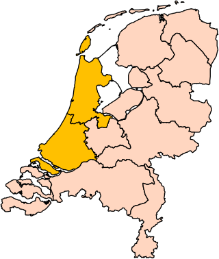
Holland is a geographical region and former province on the western coast of the Netherlands. From the 10th to the 16th century, Holland proper was a unified political region within the Holy Roman Empire as a county ruled by the counts of Holland. By the 17th century, the province of Holland had risen to become a maritime and economic power, dominating the other provinces of the newly independent Dutch Republic.

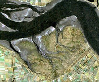
A polder is a low-lying tract of land that forms an artificial hydrological entity, enclosed by embankments known as dikes. The three types of polder are:
- Land reclaimed from a body of water, such as a lake or the seabed
- Flood plains separated from the sea or river by a dike
- Marshes separated from the surrounding water by a dike and subsequently drained; these are also known as koogs, especially in Germany

The Zuiderzee or Zuider Zee, historically called Lake Almere and Lake Flevo, was a shallow bay of the North Sea in the northwest of the Netherlands. It extended about 100 km inland and at most 50 km wide, with an overall depth of about 4 to 5 metres (13–16 feet) and a coastline of about 300 km. It covered 5,000 km2 (1,900 sq mi). Its name is Dutch for "southern sea", indicating that the name originates in Friesland, to the north of the Zuiderzee.

Almere is a planned city and municipality in the province of Flevoland, Netherlands across the IJmeer from Amsterdam.

Baarn is a municipality and a town in the Netherlands, near Hilversum in the province of Utrecht.

Veenendaal is a municipality and a town in central Netherlands, located in the province of Utrecht. Veenendaal is the only population centre within its administrative borders. The municipality had a population of 70.000 inhabitants on 8 august 2024 and covers an area of 19.72 km2 (7.61 sq mi).

Amstelveen is a municipality and city in the province of North Holland, Netherlands, with a population of 92,353 as of 2022. It is a suburban part of the Amsterdam metropolitan area.

Heerhugowaard is a city in the Netherlands, in the province of North Holland and the region of West Friesland.

Schoonhoven is a town and former municipality in the western Netherlands, in the province of South Holland. Since 2015 it has been a part of the municipality of Krimpenerwaard, before it had been an independent municipality.
Voorburg is a town and former municipality in the west part of the province of South Holland, Netherlands. Together with the town Leidschendam and the village Stompwijk, it merged into the municipality of Leidschendam-Voorburg in 2002. Situated adjacent to the city of The Hague, it is often regarded as one of its suburbs.
Ommoord is a neighbourhood in the former borough Prins Alexander, part of the municipality of Rotterdam, South Holland, the Netherlands. Ommoord is surrounded by the neighbourhoods Zevenkamp, Het Lage Land and Terbregge. It has around 25,000 inhabitants across 12,500 households. Ommoord shares postal codes 3068 and 3069 with Zevenkamp.

Zevenkamp is a neighbourhood in the borough Prins Alexander, Rotterdam.
Saeftinghe or Saaftinge was a town in the southwest Netherlands, located in eastern Zeelandic Flanders, near Nieuw-Namen. It existed until 1584. It is now a swamp known as the Drowned Land of Saeftinghe and an official nature reserve area. The land is a crosspoint where the river Scheldt meets the salty waters of the North Sea in the estuary Western Scheldt. It is a treacherous place where the tides easily consume large stretches of land in a matter of seconds and must not be explored without an experienced guide.

The Alblasserwaard is a polder in the province of South Holland, Netherlands. It is mainly known for the windmills of Kinderdijk, located near the village of Kinderdijk in the polder's northwestern part.

Nesselande is a new extension on the east side of the city of Rotterdam, in South Holland, the Netherlands. It is part of the borough of Prins Alexander, formerly Zevenhuizen-Moerkapelle.

Rijkswaterstaat, founded in 1798 as the Bureau voor den Waterstaat and formerly translated to Directorate General for Public Works and Water Management, is a Directorate-General of the Ministry of Infrastructure and Water Management of the Netherlands. Its role is the practical execution of the public works and water management, including the construction and maintenance of waterways and roads, and flood protection and prevention. The agency was also involved in the construction of big railway projects such as the Betuweroute and the HSL-Zuid.

Rotterdam Alexander is a combined metro and railway station in Rotterdam, Netherlands. It is located on the Utrecht–Rotterdam railway. It is named after Prins Alexander borough, and therefore indirectly after Alexander, Prince of Orange. Near the station is shopping mall Alexandrium situated.

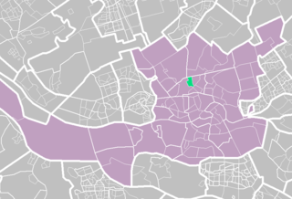
The Rotte is a river in the Rhine-Maas-delta in the Netherlands. The Rotte is the eponym of the city of Rotterdam: the city's name references a dam which local inhabitants built across the river in the 13th century CE.

Blijdorp is a neighbourhood in northern Rotterdam and is part of the borough Noord. The neighbourhood has around 9500 inhabitants.
Bergpolder is a neighborhood of Rotterdam, Netherlands in Rotterdam-Noord. Since November 5, 2014, the district is part of the protected historic area "Rijksbeschermd gezicht Blijdorp/Bergpolder".

