Holland is a geographical region and former province on the western coast of the Netherlands. From the 10th to the 16th century, Holland proper was a unified political region within the Holy Roman Empire as a county ruled by the counts of Holland. By the 17th century, the province of Holland had risen to become a maritime and economic power, dominating the other provinces of the newly independent Dutch Republic.
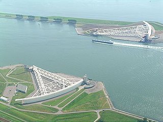
The Nieuwe Waterweg is a ship canal in the Netherlands from het Scheur west of the town of Maassluis to the North Sea at Hook of Holland: the Maasmond, where the Nieuwe Waterweg connects to the Maasgeul. It is the artificial mouth of the river Rhine.

Rotterdam is the second-largest city in the Netherlands after the national capital of Amsterdam. It is in the province of South Holland, part of the North Sea mouth of the Rhine–Meuse–Scheldt delta, via the "New Meuse" inland shipping channel, dug to connect to the Meuse at first and now to the Rhine.
Excelsior Rotterdam, commonly known as Excelsior, is a Dutch professional football club based in Rotterdam, Netherlands. They play in the Eredivisie, the top tier of Dutch football from the 2022–23 season following promotion. The club was founded on 23 July 1902 and was formerly known as "Rotterdamse Voetbal en Atletiek Vereniging Excelsior". Excelsior's home stadium is the Stadion Woudestein – for sponsorship reasons known as the Van Donge & De Roo Stadion – which has a capacity of about 4,500, one of the smallest stadiums hosting professional football in the Netherlands.

Hoogvliet is a borough of Rotterdam, Netherlands. As of 1 January 2004, it had 36,619 inhabitants. There is also a national chain of Dutch supermarkets with the same name.
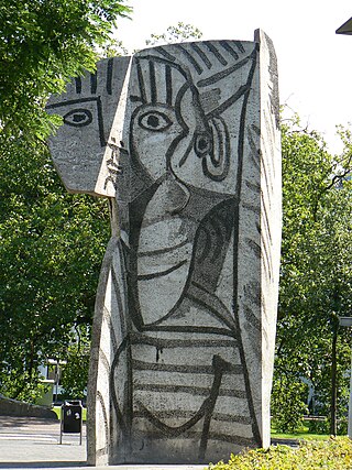
Sylvette is a large concrete sculpture created by Pablo Picasso and the Norwegian artist Carl Nesjar, which was erected in the city of Rotterdam in 1970. It is located on the corner of Westersingel next to the Museum Boijmans Van Beuningen. The sculpture portrays a young woman with a ponytail. The model for the sculpture was Sylvette David, whom Picasso met in 1953 when she was 19. The sculpture was produced following the creation of a series of artworks, known as the Sylvette series, that Picasso made of his muse in a variety of artistic styles.

The Alblasserwaard is a polder in the province of South Holland, Netherlands. It is mainly known for the windmills of Kinderdijk, located near the village of Kinderdijk in the polder's northwestern part.

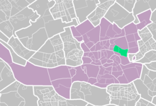
Kralingen-Crooswijk is a township of the city of Rotterdam, Netherlands. It is located at the immediate east of the city's centre. As of 2005 it has about 52,379 inhabitants and has a territory of about 1,286 ha. It consists of the two boroughs Kralingen and Crooswijk, the former being a village itself until it was incorporated in the city of Rotterdam in the late 19th century.
IJsselmonde is a former village in the Dutch province of South Holland. It was located to the east of the city of Rotterdam. The village derives its name from the river Hollandsche IJssel, which flows into the Nieuwe Maas opposite the village. The village gives its name to the large island it's on, IJsselmonde.

Overschie is a neighborhood of Rotterdam, Netherlands, formerly a separate village with its own municipality.

Schiebroek is a former village in the province of South Holland, Netherlands. It is now a neighbourhood of Rotterdam, and part of the borough of Hillegersberg-Schiebroek.

Rotterdam Lombardijen is a railway station in the Dutch city of Rotterdam, located on the Breda–Rotterdam railway between Rotterdam and Dordrecht. The railway station is located in the borough of IJsselmonde. The station opened on 1 June 1964 with wooden platforms and no more than a trailer for ticket sales. On 12 September 1968 a station building was opened; the current station building dates from 1996. Train services are operated by Nederlandse Spoorwegen.
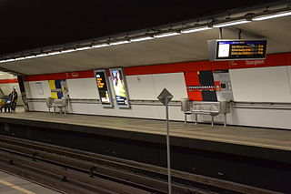
Oostplein is an underground station in the city of Rotterdam, located on the Rotterdam Metro lines A, B, and C. The station opened on 10 May 1982, the same date that the East-West Line, of which it is a part, was opened.

Kralingse Zoom is a subway station on lines A, B, and C of the Rotterdam Metro, in the Kralingen neighbourhood of eastern Rotterdam. The station is located just west of the A16 motorway on the east side of Kralingse Zoom, the road it is named after. At Kralingse Zoom station, transfer is available to several bus lines, as well as to the ParkShuttle, a people mover to a nearby business district.

Crooswijk is a neighborhood of Rotterdam, Netherlands. Crooswijk lies between the districts Kralingen, Oude Noorden and Centrum. Crooswijk was once known for its Marines barracks. Many streets bear witness to a military history of the Marine Corps: Tamboerstraat, Pijperstraat, Schuttersveld, Excercitiestraat, Vaandrigstraat. Crooswijk also has an industrial past. Jamin, Heineken Brewery and many abattoirs were established there. These industries have given way to housing. On the Crooswijksesingel is only the monumental building of Heineken still standing. Crooswijk is one of the original people's neighborhoods of Rotterdam and the district is strongly associated with the 'real' Rotterdammer. The Crooswijk is sometimes called: "The poorest part of the Netherlands", or: "The poorest part of Rotterdam". This is because the average income of the people living there is lower than other places.

Kleiwegkwartier is a neighbourhood quarter in Rotterdam, Netherlands. It is in the southern part of Hillegersberg with origins dating from the early 1600s.

In 1940, Rotterdam was subjected to heavy aerial bombardment by the Luftwaffe during the German invasion of the Netherlands during the Second World War. The objective was to support the German troops fighting in the city, break Dutch resistance and force the Dutch army to surrender. Bombing began at the outset of hostilities on 10 May and culminated with the destruction of the entire historic city centre on 14 May, an event sometimes referred to as the Rotterdam Blitz. According to an official list published in 2022, at least 1,150 people were killed, with 711 deaths in the 14 May bombing alone, and 85,000 more were left homeless.

The Holland Pop Festival, also known as the Kralingen Music Festival, was a pop and rock music festival held in the Kralingse Bos, in the Kralingen neighbourhood of Rotterdam in the Netherlands, on 26–28 June 1970.
's-Gravenweg 168, Kralingen, Rotterdam is a Louis XIV-XV façade house ca. 1850 that is classified as a Dutch National Heritage Site.
The CHIO Rotterdam is an annual international horse show held in Rotterdam, Netherlands. The show is held every year in June. Is the largest international equestrian outdoor event in The Netherlands, hosted at the 'Rotterdamse Manege' in Kralingen.