
Detroit is the largest city in the U.S. state of Michigan. It is also the largest U.S. city on the United States–Canada border, and the seat of government of Wayne County. The City of Detroit had a population of 639,111 at the 2020 census, making it the 27th-most populous city in the United States. The metropolitan area, known as Metro Detroit, is home to 4.3 million people, making it the second-largest in the Midwest after the Chicago metropolitan area, and the 14th-largest in the United States. Regarded as a major cultural center, Detroit is known for its contributions to music, art, architecture and design, in addition to its historical automotive background. Time named Detroit as one of the fifty World's Greatest Places of 2022 to explore.

Gentrification is the process of changing the character of a neighborhood through the influx of more affluent residents and businesses. It is a common and controversial topic in urban politics and planning. Gentrification often increases the economic value of a neighborhood, but the resulting demographic displacement may itself become a major social issue. Gentrification often sees a shift in a neighborhood's racial or ethnic composition and average household income as housing and businesses become more expensive and resources that had not been previously accessible are extended and improved.

Brooklyn is a borough of New York City, coextensive with Kings County, in the U.S. state of New York. Kings County is the most populous county in the State of New York, and the second-most densely populated county in the United States, behind New York County (Manhattan). Brooklyn is also New York City's most populous borough, with 2,736,074 residents in 2020.

San Francisco, officially the City and County of San Francisco, is a commercial, financial, and cultural center of Northern California. The city proper is the fourth most populous in California, with 815,201 residents as of 2021, and covers a land area of 46.9 square miles, at the end of the San Francisco Peninsula, making it the second most densely populated large U.S. city after New York City and the fifth most densely populated U.S. county, behind only four of the five New York City boroughs. Among the 91 U.S. cities proper with over 250,000 residents, San Francisco was ranked first by per capita income and sixth by aggregate income as of 2021. Colloquial nicknames for San Francisco include SF, San Fran, The City, Frisco, and Baghdad by the Bay.

Hollywood is a neighborhood in the central region of Los Angeles, California. Its name has come to be a shorthand reference for the U.S. film industry and the people associated with it. Many notable film studios, such as Columbia Pictures, Walt Disney Studios, Paramount Pictures, Warner Bros., and Universal Pictures, are located near or in Hollywood.

Harlem is a neighborhood in Upper Manhattan, New York City. It is bounded roughly by the Hudson River on the west; the Harlem River and 155th Street on the north; Fifth Avenue on the east; and Central Park North on the south. The greater Harlem area encompasses several other neighborhoods and extends west and north to 155th Street, east to the East River, and south to Martin Luther King Jr. Boulevard, Central Park, and East 96th Street.

In the United States, redlining is a discriminatory practice in which services are withheld from potential customers who reside in neighborhoods classified as "hazardous" to investment; these neighborhoods have significant numbers of racial and ethnic minorities, and low-income residents. While the most well-known examples involve denial of credit and insurance, also sometimes attributed to redlining in many instances are: denial of healthcare and the development of food deserts in minority neighborhoods. In the case of retail businesses like supermarkets, the purposeful construction of stores impractically far away from targeted residents results in a redlining effect.
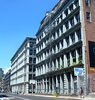
SoHo, sometimes written Soho, is a neighborhood in Lower Manhattan, New York City. Since the 1970s, the neighborhood has been the location of many artists' lofts and art galleries, and has also been known for its variety of shops ranging from trendy upscale boutiques to national and international chain store outlets. The area's history is an archetypal example of inner-city regeneration and gentrification, encompassing socioeconomic, cultural, political, and architectural developments.
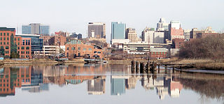
Wilmington is the largest city in the U.S. state of Delaware. The city was built on the site of Fort Christina, the first Swedish settlement in North America. It lies at the confluence of the Christina River and Brandywine Creek, two waterways near where the Christina flows into the Delaware River, which is a river. It is the county seat of New Castle County and one of the major cities in the Delaware Valley metropolitan area. Wilmington was named by Proprietor Thomas Penn after his friend Spencer Compton, Earl of Wilmington, who was prime minister during the reign of George II of Great Britain.

Fred McFeely Rogers, better known as Mister Rogers, was an American television host, author, producer, and Presbyterian minister. He was the creator, showrunner, and host of the preschool television series Mister Rogers' Neighborhood, which ran from 1968 to 2001.

Mister Rogers' Neighborhood is an American half-hour educational children's television series that ran from 1968 to 2001, and was created and hosted by Fred Rogers. The series Misterogers debuted in Canada on October 15, 1962, on CBC Television. In 1966, Rogers moved back to the United States creating Misterogers' Neighborhood, later called Mister Rogers' Neighborhood, on the regional Eastern Educational Television Network. The US national debut of the show occurred on February 19, 1968. It aired on NET and its successor, PBS, until August 31, 2001.

A neighbourhood or neighborhood is a geographically localised community within a larger city, town, suburb or rural area, sometimes consisting of a single street and the buildings lining it. Neighbourhoods are often social communities with considerable face-to-face interaction among members. Researchers have not agreed on an exact definition, but the following may serve as a starting point: "Neighbourhood is generally defined spatially as a specific geographic area and functionally as a set of social networks. Neighbourhoods, then, are the spatial units in which face-to-face social interactions occur—the personal settings and situations where residents seek to realise common values, socialise youth, and maintain effective social control."

A chi-squared test is a statistical hypothesis test used in the analysis of contingency tables when the sample sizes are large. In simpler terms, this test is primarily used to examine whether two categorical variables are independent in influencing the test statistic. The test is valid when the test statistic is chi-squared distributed under the null hypothesis, specifically Pearson's chi-squared test and variants thereof. Pearson's chi-squared test is used to determine whether there is a statistically significant difference between the expected frequencies and the observed frequencies in one or more categories of a contingency table. For contingency tables with smaller sample sizes, a Fisher's exact test is used instead.

Haight-Ashbury is a district of San Francisco, California, named for the intersection of Haight and Ashbury streets. It is also called The Haight and The Upper Haight. The neighborhood is known as one of the main centers of the counterculture of the 1960s.

The city of Chicago is divided into 77 community areas for statistical and planning purposes. Census data and other statistics are tied to the areas, which serve as the basis for a variety of urban planning initiatives on both the local and regional levels. The areas' boundaries do not generally change, allowing comparisons of statistics across time. The areas are distinct from but related to the more numerous neighborhoods of Chicago; an area often corresponds to a neighborhood or encompasses several neighborhoods, but the areas do not always correspond to popular conceptions of the neighborhoods due to a number of factors including historical evolution and choices made by the creators of the areas. As of 2020, Near North Side is the most populous of the areas with over 105,000 residents, while Burnside is the least populous with just over 2,500. Other geographical divisions of Chicago exist, such as the "sides" created by the branches of the Chicago River, the wards of the Chicago City Council, and the parishes of the Roman Catholic Church.

Kensington, colloquially known locally as “Kenzo,” is a neighborhood in Philadelphia that belongs to or divides Lower Northeast and North Philadelphia. As with all neighborhoods in the city, the lack of any official designation means the boundaries of the area vary between sources over time and are disputed among locals. Kensington, as most long-term residents view it, refers generally to the area consisting of Kensington, East, or Lower Kensington, West Kensington, and Harrowgate. The adjacent Fairhill and Norris Square neighborhoods are more separate but may be included in Kensington; Fishtown and South (Olde) Kensington were previously included but have developed new identities with gentrification. The most conservative boundaries of the neighborhood, shown in the map below, are Front Street and 5th Street to the west, the Amtrak train tracks to the North, Trenton Avenue, the Trenton Avenue train tracks, and Frankford Avenue to the east, and Cecil B. Moore Avenue to the south.

The neighborhoods in New York City are located within the five boroughs of the City of New York. Their names and borders are not officially defined, and they change from time to time.

Daniel Tiger's Neighborhood is a Flash animated musical television series aimed at preschool children ages 2 to 4. It was produced by Fred Rogers Productions, 9 Story Media Group and 9 Story USA. It debuted on September 3, 2012 on PBS Kids, eleven years after the end of production for Mister Rogers' Neighborhood and nine years after Fred Rogers' death. The program is based on the Neighborhood of Make-Believe from Mister Rogers, the long-running family-oriented television series created and hosted by Fred Rogers that aired from 1968 to 2001. In 2019, the series was renewed for a fifth season, which premiered on August 17, 2020 with Daniel Tiger's Neighborhood: Won't You Sing Along with Me?, a musical special that deals with the COVID-19 pandemic. On August 20, 2021, the series was renewed for a sixth season, which premiered on September 5, 2022. A one-hour television movie titled Daniel Visits a New Neighborhood aired on June 20, 2022.
