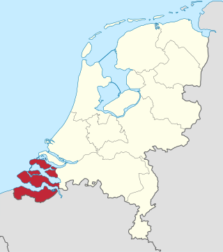
Zeeland, historically known in English by the exonym Zealand, is the westernmost and least populous province of the Netherlands. The province, located in the southwest of the country, borders North Brabant to the east, South Holland to the north, as well as the country of Belgium to the south and west. It consists of a number of islands and peninsulas and a strip bordering the Flemish provinces of East and West Flanders. Its capital is Middelburg with a population of 48,544 as of November 2019, although the largest municipality in Zeeland is Terneuzen. Zeeland has two seaports: Vlissingen and Terneuzen. Its area is 2,933 square kilometres (1,132 sq mi), of which 1,154 square kilometres (446 sq mi) is water; it had a population of about 391,000 as of January 2023.

The Scheldt is a 435-kilometre-long (270 mi) river that flows through northern France, western Belgium, and the southwestern part of the Netherlands, with its mouth at the North Sea. Its name is derived from an adjective corresponding to Old English sċeald ("shallow"), Modern English shoal, Low German schol, West Frisian skol, and obsolete Swedish skäll ("thin").

Walcheren is a region and former island in the Dutch province of Zeeland at the mouth of the Scheldt estuary. It lies between the Eastern Scheldt in the north and the Western Scheldt in the south and is roughly the shape of a rhombus. The two sides facing the North Sea consist of dunes and the rest of its coastline is made up of dykes. Middelburg, the provincial capital, lies at Walcheren's centre. Vlissingen, 9 kilometres (5.6 mi) to the south, is the main harbour and the third municipality is Veere.

The Zuid-Willemsvaart is a canal in the south of the Netherlands and the east of Belgium.

The Bridgwater and Taunton Canal is a canal in the south-west of England between Bridgwater and Taunton, opened in 1827 and linking the River Tone to the River Parrett. There were a number of abortive schemes to link the Bristol Channel to the English Channel by waterway in the 18th and early 19th centuries. These schemes followed the approximate route eventually taken by the Bridgwater and Taunton Canal, but the canal was instead built as part of a plan to link Bristol to Taunton by waterway.

Zuid-Beveland is part of the province of Zeeland in the Netherlands north of the Western Scheldt and south of the Eastern Scheldt.

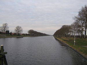
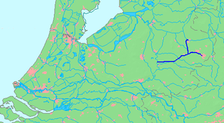
The Canal through Zuid-Beveland in the southwest Netherlands is the westernmost of two canals crossing the Zuid-Beveland peninsula. It connects the Western Scheldt near Hansweert via a lock complex and the Eastern Scheldt with which it has an open connection.

The Swansea Canal was a canal constructed by the Swansea Canal Navigation Company between 1794 and 1798, running for 16.5 miles (26.6 km) from Swansea to Hen Neuadd, Abercraf in South Wales. It was steeply graded, and 36 locks were needed to enable it to rise 373 feet (114 m) over its length. The main cargos were coal, iron and steel, and the enterprise was profitable.

The Rhine–Herne Canal is a 45.6-kilometre-long (28.3 mi) transportation canal in the Ruhr area of North Rhine-Westphalia, Germany, with five canal locks. The canal was built over a period of eight years and connects the harbour in Duisburg on the Rhine with the Dortmund-Ems Canal near Henrichenburg, following the valley of the Emscher. It was widened in the 1980s. The Rhein-Herne canal ship was designed specifically for this canal; normally of about 1300–1350 ton capacity, it has a maximum draft of 2.50 metres (8.2 ft), a length of approximately 80 metres (260 ft), and maximum beam of 9.50 metres (31.2 ft).
The Battle of Walcheren Causeway was an engagement of the Battle of the Scheldt between the 5th Canadian Infantry Brigade, elements of the British 52nd (Lowland) Infantry Division and troops of the German 15th Army in 1944. It was the first of many conflicts on and around Walcheren Island during the Scheldt battles. It was also the second major battle fought over a terrain feature known as the Sloedam during the Second World War.
The Twentekanaal is a canal running through the Dutch provinces of Gelderland and Overijssel, connecting the three largest cities of the Twente region, Almelo, Hengelo and Enschede to the national network of rivers and canals. Because the canal forks to reach Almelo, the canal is officially plural, which is Twentekanalen.
The Battle of Zeeland occurred on the Western Front during the early stages of the German assault on France and the Low Countries during World War II. Several Dutch and French units attempted to hold off the German onslaught by making a determined defense of the Dutch province of Zeeland. The battle lasted eight days and was a defeat for the French and Dutch forces defending the province.
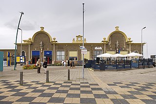
Vlissingen is a terminus railway station in Vlissingen, Netherlands. The station opened on 1 September 1873. The station is at the western end of the Roosendaal–Vlissingen railway and has 3 platforms. This station is less than 100 metres (330 ft) short of being the westernmost station in the Netherlands: that is Vlissingen Souburg, the second station in Vlissingen. The station Vlissingen was formerly called Station Vlissingen-Haven.

The Port of Mersin, is a major seaport located on the north-eastern coast of Mediterranean Sea in Mersin, southern Turkey. As one of the largest harbors in the country, it is Turkey's main gateway to the Mediterranean Sea. It was constructed during the 1950s as a major government project. It is the country's second largest port after Ambarli, near Istanbul. Owned by the Turkish State Railways (TCDD), its operating right is transferred on May 11, 2007, to PSA – Akfen consortium for a period of 36 years.

The Inundation of Walcheren was the intentional, but uncontrolled military inundation, effected by bombing the sea dikes of the former island of Walcheren in Zeeland by the Allies on and after 3 October 1944 in the context of Operation Infatuate during the Battle of the Scheldt after the Allied Invasion of Normandy during World War II. Though the inundation was justified by military necessity, it is controversial whether it was proportional in view of the predictable devastating effects for the civilian population, and the ecology of the island. The fact that the breaches in the sea dikes of the island remained open for a very long time, subjecting the island to the full impact of the twice-daily tides, caused severe damage to agricultural land and infrastructure, and severe hardship for the civilian population. Leaving the breaches open for such a long time, which was unavoidable due to the war-time lack of resources making closing impossible, subjected them to scouring by the tides, that widened and deepened them to such an extent that closing them eventually became extremely difficult, necessitating the development of new dike-building techniques, such as the use of caissons. The last breach was closed on 23 October 1945 and the draining of the island took until early 1946. Only after that could rebuilding the infrastructure and reconstructing the housing stock and the island's economy start. Walcheren was spared during the North Sea Flood of 1953 that devastated many other parts of Zeeland.

The Máxima Canal dates from 2014 and runs from the Zuid-Willemsvaart near Den Dungen to the Meuse near Gewande.

Vlissingen Navy Drydock is a dry dock in Vlissingen. It is the oldest dry dock of the Netherlands, and is now a tourist attraction known as Dok van Perry.
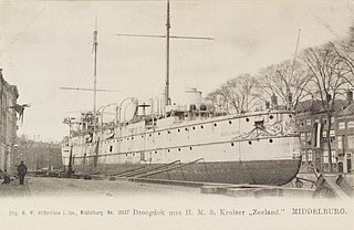
Middelburg Drydock is a former dry dock in Middelburg, Netherlands. The Dock chamber still exists.

Engelen Lock is a lock with vertical-lift bridge in the Dieze Canal near Engelen, North Brabant, just before the canal exits into the Meuse.

The Wilhelmina Canal is a canal in North-Brabant, Netherlands. It connects Tilburg to the Meuse, and continues to the east to connect to the Zuid-Willemsvaart north of Helmond.