Nieuw- en Sint Joosland

Last updated

Nieuw- en Sint Joosland
Village
Nieuwland.jpg
Nieuw- en Sint-Joosland wapen.svg
2010-NL-P09-Zeeland-positiekaart-gemnamen.jpg
Red pog.svg
Nieuw- en Sint Joosland
Location in the province of Zeeland in the Netherlands
Netherlands location map.svg
Red pog.svg
Nieuw- en Sint Joosland
Nieuw- en Sint Joosland (Netherlands)
Coordinates: 51°28′55″N3°39′28″E / 51.48194°N 3.65778°E / 51.48194; 3.65778 Coordinates: 51°28′55″N3°39′28″E / 51.48194°N 3.65778°E / 51.48194; 3.65778
Country Netherlands
Province Zeeland
Municipality Middelburg
Area
[1]
  Total0.50 km2 (0.19 sq mi)
Elevation
[2]
1.4 m (4.6 ft)
Population
 (2021) [1]
  Total1,165
  Density2,300/km2 (6,000/sq mi)
Time zone UTC+1 (CET)
  Summer (DST) UTC+2 (CEST)
Postal code
4339 [1]
Dialing code 0118

Nieuw- en Sint Joosland of Nieuwland (Zeeuws: 't Nieuwland) is a village and a former municipality in the southeast of Walcheren, at the edge of the island, in the municipality Middelburg, in the Dutch province of Zeeland. It has about 1300 inhabitants. Because of its relatively late foundation, Nieuw- en Sint Joosland is not a churchvillage, but more of a wegdorp, despite its clear village centre.

Contents

History: polders and villages in the 17th and 18th centuries

Nieuw- en Sint Joosland arose in the seventeenth century, during the time the 'Sloe', the water that split Walcheren in two, began to bog down and the area began to be interesting for polders. In 1603 the city Middelburg bought part of the salt marsh, to sell it in 1644 to the mayor. In 1631 the 'Oud-Sint Jooslandpolder' arose, followed by the 'Middelburgse polder' in 1644. A small core arose in the 'Oud-Sint Jooslandpolder', the actual 'Sint Joosland', but it did not get any bigger; this hamlet is now called 'Oudedorp'. On this new land are, besides some farms, eight sawmills. These helped a lot with the booming trade. People called the 'Middelburgse polder' usually 'Nieuw land(New Land). Multiple polders followed: in 1661 the 'Nieuwerkerkepolder' (Newchurchpolder), in 1671 the 'Nieuw-Sint Jooslandpolder' and in 1672 the 'Molenpolder' (Millpolder). This area is not reachable by land so a ferry over the Welzinge was created. In 1650 the island was big enough for its own church.

Municipality

In 1816 the two municipalities, Nieuwland en Sint Joosland, merged into the new municipality Nieuw- en Sint Joosland, even though the last municipality existed of only one street, the still existing hamlet 'Oudedorp' (Zeelandic: 't Ouwe Durp) and a few farms. Two years later a dam was built through 'Welzinge' connecting the island with the old 'Walcheren'. Middelburg had already dug a channel to Veere, but this was no longer needed. Because of this, the wood industry in 'Nieuw- en Sint Joosland' was redundant, that is why they concentrated on agriculture instead. In 1966 the village 'Nieuwland' and the hamlet 'Oudedorp' were added to Middelburg. More than half of the territory, almost 8 km2, belongs to the municipality Vlissingen, around 7 km2 to Middelburg and 7 ha to Arnemuiden. During the municipal reorganization of 1997 the village received the northern part of the 'Nieuw- en Sint Jooslandpolder' back from Vlissingen.
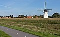
Buildings

The Dutch Reformed Church of 'Nieuwland' was built in 1882; the wall around the church is still from the old church. A bit outside the village is the gristmill 'Buiten Verwachting', built in 1874.

Related Research Articles

Zeeland Province of the Netherlands

Zeeland is the westernmost and least populous province of the Netherlands. The province, located in the south-west of the country, borders North Brabant to the east, South Holland to the north, and the country of Belgium to the south and west. It consists of a number of islands and peninsulas and a strip bordering the Flemish provinces of East and West Flanders. Its capital is Middelburg with a population of 48,544 as of November 2019, the largest municipality in Zeeland is Terneuzen. Zeeland has two seaports: Vlissingen and Terneuzen. Its area is 2,934 square kilometres (1,130 sq mi), of which 1,151 square kilometres (440 sq mi) is water, and it has a population of 383,689 as of November 2019.

Walcheren Former Island in Zeeland, Netherlands

Walcheren is a region and former island in the Dutch province of Zeeland at the mouth of the Scheldt estuary. It lies between the Eastern Scheldt in the north and the Western Scheldt in the south and is roughly the shape of a rhombus. The two sides facing the North Sea consist of dunes and the rest of its coastline is made up of dykes. Middelburg, the provincial capital, lies at Walcheren's centre. Vlissingen, 9 kilometres (5.6 mi) to the south, is the main harbour and the third municipality is Veere.

Middelburg, Zeeland City and municipality in Zeeland, Netherlands

Middelburg is a city and municipality in the south-western Netherlands serving as the capital of the province of Zeeland. Situated on the central peninsula of the Zeeland province, Midden-Zeeland, it has a population of about 48,000.

Oud-Beijerland Town in South Holland, Netherlands

Oud-Beijerland is a town and former municipality in the western Netherlands, in the province of South Holland, now a part of the Hoeksche Waard municipality. With a population of 24,575 in 2020, it is the most populous town of the Hoeksche Waard island. The town is located adjacent to the confluence of the Oude Maas and Spui River.

Canal through Walcheren

The Canal through Walcheren in the Netherlands crosses the east of Walcheren. It connects the Westerschelde and the Veerse Meer.

Oud-Vossemeer Village in Zeeland, Netherlands

Oud-Vossemeer is a village on the island of Tholen in the Dutch province of Zeeland. It is a part of the municipality of Tholen, and lies about 13 km northwest of Bergen op Zoom, close to the Eendracht, part of the Scheldt-Rhine Canal.

Domburg City in Zeeland, Netherlands

Domburg is a seaside resort on the North Sea, on the northwest coast of Walcheren in the Dutch province of Zeeland. It is a part of the municipality of Veere, and lies about 11 km northwest of the city of Middelburg, the provincial capital.

Zeelandic

Zeelandic is a group of Friso-Franconian language varieties spoken in the southwestern parts of the Netherlands. It is currently considered a Low Franconian dialect of Dutch, but there have been movements to promote the status of Zeelandic from a dialect of Dutch to a separate regional language, which have been denied by the Dutch Ministry of Internal Affairs. More specifically, it is spoken in the southernmost part of South Holland (Goeree-Overflakkee) and large parts of the province of Zeeland, with the notable exception of eastern Zeelandic Flanders.

Nieuwer-Ter-Aa Village in Utrecht, Netherlands

Nieuwer-Ter-Aa is a village in the Dutch province of Utrecht (province). It is a part of the municipality of Stichtse Vecht, and lies about 13 km northwest of Utrecht.

Nieuwland, Vijfheerenlanden Village in Utrecht, Netherlands

Nieuwland is a village in the Dutch province of Utrecht. It is a part of the municipality of Vijfheerenlanden, and lies about 8 km north of Gorinchem.

Vierpolders Village in South Holland, Netherlands

Vierpolders is a village in the Dutch province of South Holland. It is a part of the municipality of Brielle, and lies about 5 km north of Hellevoetsluis.

Nieuw-Beijerland Village in South Holland, Netherlands

Nieuw-Beijerland is a village in the Dutch province of South Holland. It is a part of the municipality of Hoeksche Waard, and lies about 3 km south of Spijkenisse.

Nieuwland is the name of several Dutch villages:

Nieuwland is a former municipality in the Dutch province of Zeeland. It existed until 1816, when it was merged with Sint Joosland to form the new municipality of Nieuw- en Sint Joosland.

Sint Joosland is a former municipality in the Dutch province of Zeeland. It existed until 1816, when it was merged with Nieuwland to form the new municipality of Nieuw- en Sint Joosland. The municipality consisted of a single polder southeast of the current village of Nieuw- en Sint Joosland.

Klaaswaal Village in South Holland, Netherlands

Klaaswaal is a village and former municipality in the Dutch province of South Holland. It is centrally located on one of the island Hoeksche Waard. Klaaswaal was a separate municipality until 1984, when it was merged with Numansdorp to form the municipality Cromstrijen.

Maasdam Village in South Holland, Netherlands

Maasdam is a village in the Dutch province of South Holland. It is located about 14 km south of the city of Rotterdam, in the municipality of Hoeksche Waard, on the rural Hoeksche Waard island. From the 14th Century until around 1800, Maasdam was also the name of the local administrative area, the fief and later the "ambacht".

Sint Anthoniepolder Hamlet in South Holland, Netherlands

Sint Anthoniepolder is a hamlet in the Dutch province of South Holland. It is located about 14 km south of the city of Rotterdam, in the municipality of Hoeksche Waard.

Sint-Michielsgestel Place in North Brabant, Netherlands

Sint-Michielsgestel is a village in the municipality of Sint-Michielsgestel, Netherlands.

Sabbinge Castle Castle in the Netherlands

Sabbinge Castle is a small castle in Oud-Sabbinge, on the former island Wolphaartsdijk

References

  1. 1 2 3 "Kerncijfers wijken en buurten 2021". Central Bureau of Statistics. Retrieved 20 April 2022.
  2. "Postcodetool for 4339AA". Actueel Hoogtebestand Nederland (in Dutch). Het Waterschapshuis. Retrieved 20 April 2022.