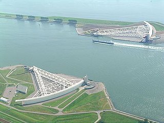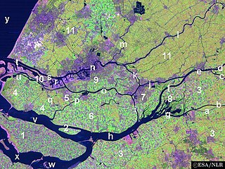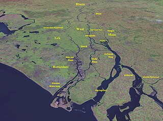
The Nieuwe Waterweg is a ship canal in the Netherlands from het Scheur west of the town of Maassluis to the North Sea at Hook of Holland: the Maasmond, where the Nieuwe Waterweg connects to the Maasgeul. It is the artificial mouth of the river Rhine.

IJsselmonde is a river island in the Netherlands, between the Nieuwe Maas, Noord and Oude Maas branches rivers of the Rhine-Meuse delta in the province of South Holland. The city of Rotterdam now occupies most of the northern part of the island and includes the eponymous former village of IJsselmonde, once a separate community. The island was once a rich agricultural region but is mostly suburbs today. Only the mid-south parts of the island have retained their agricultural character.

Rozenburg is a town and former municipality in the western Netherlands, in the province of South Holland. The municipality had a population of 13,173 in 2004, and covers an area of 6.50 km2. It was the second-smallest municipality in the Netherlands in area. On 10 July 2008, the local council decided to disband the municipality and to form a submunicipality of Rotterdam. This was ratified on 27 October 2009 by the Eerste Kamer, and came into effect on 18 March 2010.

The Beneden Merwede is a stretch of river in the Netherlands, mainly fed by the river Rhine. It starts as the continuation of the Boven Merwede after the branching-off of the Nieuwe Merwede ship canal. It flows from Hardinxveld-Giessendam to Dordrecht, where it splits into the Noord and Oude Maas rivers. Its length is 14.8 km. The river is part of the main shipping route between the port of Rotterdam and the industrial region of the Ruhr, Germany.

The Boven Merwede is a stretch of river in the Netherlands, mainly fed by the river Rhine. The Afgedamde Maas river joins the Waal at Woudrichem to form the Boven Merwede, which at Hardinxveld-Giessendam splits into the Beneden Merwede river on the right and the Nieuwe Merwede river on the left. Its length is 8.8 km (5.5 mi). The Merwede is part of the main shipping route between Rotterdam and Germany.

Europoort is an area of the Port of Rotterdam and the adjoining industrial area in the Netherlands. Being situated at Southside of the mouth of the rivers Rhine and Meuse with the hinterland consisting of the Netherlands, Germany, Belgium and partly France, Europoort is one of the world's busiest ports and considered a major entry to Europe. The port handled 12 million containers in 2015.

The Scheur is a branch of the Rhine-Meuse delta in South Holland, Netherlands, that flows west from the confluence of the Oude Maas and Nieuwe Maas branches past the towns of Rozenburg and Maassluis. It continues as the Nieuwe Waterweg to the North Sea.

The Brielse Meer is a long, narrow lake between the Dutch estuary islands of Voorne and Rozenburg in the province of South Holland.

Delfshaven is a borough of Rotterdam, Netherlands, on the right bank of river Nieuwe Maas. It was a separate municipality until 1886.

Voorne-Putten is an island between the North Sea, the Brielse Meer and the rivers Oude Maas, Spui and Haringvliet in the province of South Holland. Voorne-Putten consists of the two former islands Voorne and Putten. It used to be separated by the river Bernisse which silted up, uniting the two islands. It has 160,000 inhabitants (2008). Recently the riverbed has been dredged, and the two islands have been reformed.

The Port of Rotterdam is the largest seaport in Europe, and the world's largest seaport outside of Asia, located in and near the city of Rotterdam, in the province of South Holland in the Netherlands. From 1962 until 2004, it was the world's busiest port by annual cargo tonnage. It was overtaken first in 2004 by the port of Singapore, and since then by Shanghai and other very large Chinese seaports. In 2020, Rotterdam was the world's tenth-largest container port in terms of twenty-foot equivalent units (TEU) handled. In 2017, Rotterdam was also the world's tenth-largest cargo port in terms of annual cargo tonnage.

The Merwede is the name of several connected stretches of river in the Netherlands, between the cities of Woudrichem, Dordrecht and Papendrecht. The river is part of the Rhine–Meuse–Scheldt delta and is mostly fed by the river Rhine.

The Rhine–Meuse–Scheldt delta is a river delta in the Netherlands formed by the confluence of the Rhine, the Meuse and the Scheldt rivers. In some cases, the Scheldt delta is considered a separate delta to the Rhine–Meuse delta. The result is a multitude of islands, branches and branch names, in which a waterway that appears to be one continuous stream may have numerous separate names for different sections, e.g. Rhine → Bijlands Kanaal → Pannerdens Kanaal → Nederrijn → Lek → Nieuwe Maas → Het Scheur → Nieuwe Waterweg. Since the Rhine contributes most of the water, the term "Rhine Delta" is commonly used, although this name is also used for the delta where the Alpine Rhine flows into Lake Constance. By some calculations, the Rhine–Meuse–Scheldt delta covers 25,347 km2 (9,787 sq mi), making it the largest in Europe.

The Nieuwe Maas is a distributary of the Rhine River, and a former distributary of the Maas River, in the Dutch province of South Holland. It runs from the confluence of the rivers Noord and Lek, and flows west through Rotterdam. It ends west of the city where it meets the Oude Maas, near Vlaardingen, to form Scheur. After a few miles, the Scheur continues as the artificial Nieuwe Waterweg. The total length of the Nieuwe Maas is approximately 24 kilometres (15 mi).

The Rotte is a river in the Rhine-Maas-delta in the Netherlands. The Rotte is the eponym of the city of Rotterdam: the city's name references a dam which local inhabitants built across the river in the 13th century CE.

Rozenburg is an island in western Netherlands, in the province of South Holland. Rozenburg Island was formed centuries ago from several sand bars in the Meuse estuary. In 1568, construction started on the first set of dikes and in 1586 the land known as Roosenburgh was leased to Dirk Ariensz. Bisdommer and Son, the first permanent inhabitant of Rozenburg.

The D'Oliphant, also written as De Oliphant, was commissioned in 1591 by Cornelis van Wijkcool as "boerenbehuizinge" built near Nieuwesluis on the island Voorne. Oliphant translates into "Elephant" although the current spelling of the Dutch word is Olifant. The octagonal tower part of the house was probably designed to give the allure of a knight homestead and to suggest that the owner belonged to an ancient and noble family. The house was moved in 1975 and is now located at the Kromme Zandweg 90 in the district of Charlois in Rotterdam.

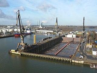
Damen Verolme Rotterdam, is a repair shipyard in Rotterdam, Netherlands.

Blankenburg is a former village that was located on the Dutch island of Rozenburg in the province of South Holland. It was located to the west of Rotterdam and to the southeast of the village of Rozenburg and was part of the Blankenburg island polder of the same name, which was created around 1600 by migrants from Blankenberge in Flanders. Soon after, it formed a single island with Rozenburg and a few embankments in the Maas estuary. The village that originated in the seventeenth century was completely abandoned in the early 1960s due to the construction of Europoort.

The Brielse Maas is a dammed river branch between the North Sea and the Oude Maas in the southern part of the Dutch province of South Holland. The town of Brielle, which gave it its name, is located on the south bank. Originally the Brielse Maas was part of the Nieuwe Maas: at the Vondelingenplaat the Oude Maas and the Nieuwe Maas came together and split into the Brielse Maas and the Scheur. The Brielse Maas was the main shipping channel and mouth of the Rijn-Maas delta.


