
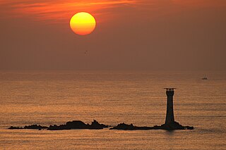
Longships Lighthouse is an active 19th-century lighthouse about 1.25 mi (2.0 km) off the coast of Land's End in Cornwall, England. It is the second lighthouse to be built on Carn Bras, the highest of the Longships islets which rises 39 feet (12 m) above high water level. In 1988 the lighthouse was automated, and the keepers withdrawn. It is now remotely monitored from the Trinity House Operations & Planning Centre in Harwich, Essex.

The Farne Islands are a group of islands off the coast of Northumberland, England. The group has between 15 and 20 islands depending on the level of the tide. They form an archipelago, divided into the Inner Group and the Outer Group. The main islands in the Inner Group are Inner Farne, Knoxes Reef, the East and West Wideopens, and the Megstone; the main islands in the Outer Group are Staple Island, Brownsman, North and South Wamses, Big Harcar, and Longstone. The two groups are separated by Staple Sound. The highest point, on Inner Farne, is 62 feet (19 m) above mean sea level.

The Bishop Rock is a skerry off the British coast in the northern Atlantic Ocean known for its lighthouse. It is in the westernmost part of the Isles of Scilly, an archipelago 45 km (28 mi) off the southwestern tip of the Cornish peninsula of Great Britain. The Guinness Book of Records lists it as the world's smallest island with a building on it.

Niton is a village on the Isle of Wight, west of Ventnor, with a population of 2,082. It has two pubs, several churches, a pottery workshop/shop, a pharmacy, a busy volunteer-run library, a medical centre and two local shops including a post office. The post office includes a pub and café that serves as a local meeting place. The village also offers a primary school with a co-located pre-school and nursery.

Round Island Lighthouse, in the Isles of Scilly was designed by William Tregarthen Douglass for Trinity House and completed in 1887. At the time of building it was one of three lights in the Isles of Scilly, the others being the Bishop Rock and St Agnes lighthouse. The light was modernised in 1966, automated in 1987 and the island designated as a Site of Special Scientific Interest (SSSI) in 1995. It is now managed by the Isles of Scilly Wildlife Trust, and except for the maintenance of the Grade II listed lighthouse, landing is not allowed.

East Brother Island Lighthouse is a lighthouse located on East Brother Island in San Rafael Bay, near the tip of Point San Pablo in Richmond, California. It marks the entrance to San Pablo Bay from San Francisco Bay.

Hartland Point is a 325 ft (99 m) high rocky outcrop of land on the north-western tip of the Devon coast in England. It is three miles (5 km) north-west of the village of Hartland. The point marks the western limit of the Bristol Channel with the Atlantic Ocean continuing to the west. This location was known to the Romans as the "promontory of Hercules".
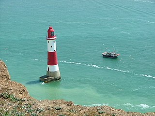
Beachy Head Lighthouse is a lighthouse located in the English Channel below the cliffs of Beachy Head in East Sussex. It is 33 m (108 ft) in height and became operational in October 1902. It was the last traditional-style 'rock tower' to be built by Trinity House.

South Foreland Lighthouses are a pair of Victorian lighthouses on the South Foreland in St. Margaret's Bay, Dover, Kent, England, used to warn ships approaching the nearby Goodwin Sands. There has been a pair of lighthouses at South Foreland since at least the 1630s. Even after the decommissioning of the Lower Lighthouse the pair continued to be used as leading marks, with Admiralty charts into the 20th century indicating that the 'Lighthouses in line lead south of the Goodwin Sands'.

Start Point lighthouse was built in 1836 to protect shipping off Start Point, Devon, England. Open to the public in summer months, it is owned and operated by Trinity House. It has been designated by English Heritage as a grade II listed building.

St Bees Lighthouse is a lighthouse located on St Bees Head near the village of St Bees in Cumbria, England. The cliff-top light is the highest in England at 102 m (335 ft) above sea level.
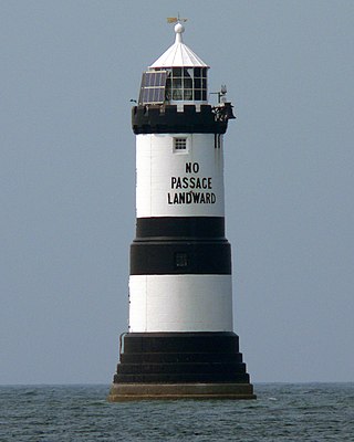
Trwyn Du Lighthouse, also known as Penmon Lighthouse, is a lighthouse between Black Point near Penmon and Ynys Seiriol, or Puffin Island, at the eastern extremity of Anglesey, marking the passage between the two islands.
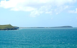
Trevose Head is a headland on the Atlantic coast of north Cornwall, United Kingdom. It is situated approximately 5 miles (8.0 km) west of Padstow. The South West Coast Path runs around the whole promontory and is within the Cornwall Area of Outstanding Natural Beauty and the Trevose Head Heritage Coast. In clear weather, visitors to Trevose Head can see virtually the whole length of the north Cornwall coast; to the north, the view extends beyond the Cornwall county boundary to Hartland Point, Devon; to the south, it extends beyond St Ives to the headland at Pendeen Watch.

The Alderney Lighthouse is a stone lighthouse built on the North-East coast of the island of Alderney. It was constructed in 1912 to protect shipping from the dangerous waters of the Alderney Race and the numerous rocks surrounding Alderney.
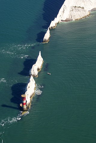
The Needles Lighthouse is an active 19th century lighthouse on the outermost of the chalk rocks at The Needles on the Isle of Wight in the United Kingdom, near sea level. Designed by James Walker, for Trinity House at a cost of £20,000. It was completed in 1859 from granite blocks, stands 33.25 metres (109.1 ft) high and is a circular tower with straight sides. It replaced an earlier light tower on top of a cliff overhanging Scratchell's Bay, which was first lit on 29 September 1786.
Les Hanois Lighthouse was constructed between 1860 and 1862 to a design by James Walker, and was first lit on 8 December 1862. It is sited on the rock known as Le Biseau, or Le Bisé, part of the reef Les Hanois one mile north west of Pleinmont where the Trinity House cottages were built. It was erected in response to an increasing number of shipwrecks on the treacherous rocks off the western coast of Guernsey.

Lowestoft Lighthouse is a lighthouse operated by Trinity House located to the north of the centre of Lowestoft in the English county of Suffolk. It stands on the North Sea coast close to Ness Point, the most easterly point in the United Kingdom. It acts as a warning light for shipping passing along the east coast and is the most easterly lighthouse in the UK.

Casquets Lighthouse is an active lighthouse located on the rocky Les Casquets, Alderney, Channel Islands.

Blackhead Lighthouse is a listed lighthouse built at the turn of the 20th century, near Whitehead in County Antrim, Northern Ireland. It marks the very northern end of Belfast Lough where it opens out into the North Channel that separates Northern Ireland and Scotland. The active lighthouse is managed by the Commissioners of Irish Lights, where it is named as the Blackhead Antrim Lighthouse to distinguish it from the more modern Blackhead lighthouse in County Clare.
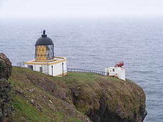
St Abb's Head Lighthouse stands on the cliffs at the rocky promontory of St Abb's Head, near the village of St Abbs in Berwickshire.


