Hurst Point Lighthouse

Last updated

Hurst Point Lighthouse
High
Hurst Point Lighthouse (19302708274).jpg
Hurst Point Lighthouse
Location Hurst Spit
Hampshire
England
OS grid SZ3184589911
Coordinates 50°42′28.7″N1°33′1″W / 50.707972°N 1.55028°W / 50.707972; -1.55028 Coordinates: 50°42′28.7″N1°33′1″W / 50.707972°N 1.55028°W / 50.707972; -1.55028
Tower
Constructed1812 (first)
Constructionmasonry tower
Automated1923
Height26 m (85 ft)
Shapecylindrical tower with balcony and lantern
Markingswhite tower and lantern
OperatorTrinity House [1]
Heritage Grade II listed building   OOjs UI icon edit-ltr-progressive.svg
Light
First lit1867 (current)
Focal height23 m (75 ft)
Lens1st order 920mm fixed lens
Intensitywhite: 7,140 candela
red: 1,760 candela
Rangewhite: 13 nmi (24 km)
red: 10 nmi (19 km)
Characteristic Fl (4) WR 15s.
F WRG at 19 metres (62 ft)

Hurst Point Lighthouse is located at Hurst Point in the English county of Hampshire, and guides vessels through the western approaches to the Solent.

Contents

History

The old lights

Left to right: Hurst Castle, old Low Lighthouse, old High Lighthouse (1840) Hurst Castle, 1840.jpg
Left to right: Hurst Castle, old Low Lighthouse, old High Lighthouse (1840)

The original lighthouse was the Hurst Tower, sited to the south west of the old Hurst Castle and lit for the first time on 29 September 1786. [2] Richard Jupp was the architect [3] and Joseph Huddart supervised and directed its construction, [4] which was undertaken at the same time as the erection of two other lights nearby: one on St Catherine's Down and the other on the clifftop above The Needles (it being envisaged that the three would be used in conjunction). [3] The red, brick-built Hurst Tower displayed a fixed white light, but the north-west part of the lantern was 'darkened' to prevent it confusing vessels navigating further along the coast to the west. [5]

The Hurst Tower light was found to be obscured behind the Needles from certain directions; consequently, in 1812, this tower was supplemented by the High Lighthouse, a new tower at a higher level. [2] The High Lighthouse, which was designed by Daniel Alexander, was a red, brick-built elliptical tower of an unusual and striking conical design. [6] The two towers together functioned as leading lights for vessels approaching through the Needles Channel; both were equipped with three Argand lamps and reflectors (those in the Low Lighthouse were shown from a lower window in the tower, while a separate lamp in the lantern room above was angled in the opposite direction, to guide vessels navigating along The Solent). [7] Each tower had been built with a keeper's cottage attached.

The new lights

The extended castle (left) and new High Lighthouse (right) on Hurst Spit. Hurst Castle, near Milford on Sea, Hampshire, England-2Oct2010.jpg
The extended castle (left) and new High Lighthouse (right) on Hurst Spit.

In light of the expansion of the Castle between 1865 and 1873, it proved necessary to replace the two lighthouses. In 1865, a new Low Light was built: a white circular granite tower with a red lantern, which was attached to the new curtain wall of the castle; then, in 1867, a new High Light was built to designs by James Douglass: [6] a freestanding 26 metre tower (which, in order to maintain the transit in relation to the channel, was positioned 15 metres to the east of the old High Light). [3] Only the top of the Low Light was visible, but a red screen was positioned outside the walls of the fort as a day-mark, so as to make the tower look 'apparently complete' when the lighthouses were in line. [8] The lights displayed were similar to those of the old towers, but the light directed up the Solent now shone from the High rather than the Low lighthouse. [9]

In the 1890s the High Light was provided with a complex new array of fixed first-order Fresnel lenses, together with a Douglass-designed six-wick lamp. According to contemporary plans, displayed in the nearby museum in the castle, the 'new' lenses were in fact old lenses reused from elsewhere: one panel 'taken from the first order dioptric apparatus formerly used at St Catherine's' and one 'taken from the central portion of the old Bishop's Rock apparatus', [10] both of which had been replaced a few years earlier. (Three sets of upper prisms were also re-used from St Catherine's.) One panel was positioned on the south-west side of the lamp and aligned with the Low Light to provide the transit guiding passage through the Needles Channel; [10] the other was positioned on the east side of the lamp to guide vessels approaching via The Solent, with a red sector in addition marking a hazard, Solent Banks. [11] In the intervening arc (i.e. between the outer Needles Rock and Sconce Point) [11] the faint light of the naked flame of the lamp was left visible [10] (at a later date a much smaller optic was incorporated to cover this arc). [12] Together with the dioptric array, a complex occulting mechanism was installed, which eclipsed the light for two seconds every ten seconds whilst maintaining a fixed light over the arc of the transit with the Low Light. [11]

The Low Lights of 1911 (left) and 1865 (right) within the west wing of Hurst Castle. Hurst Point (19930538761).jpg
The Low Lights of 1911 (left) and 1865 (right) within the west wing of Hurst Castle.

By 1911, shifting sandbanks had left the Low Light out of line with the channel. It was therefore replaced with a red square metal tower, mounted on steel joists alongside the castle wall to enable it to be moved laterally so as to adjust to future changes. It too was fitted with a first-order lens. [13] By now the towers were lit by incandescent oil burners. [14] In 1923 both lights were automated with the installation of an acetylene lamp controlled by a sun valve, fuelled from an adjacent producer plant. (The producer plant, which generated the gas using rainwater and calcium carbide, was decommissioned in 1968; stores of bottled gas were subsequently provided by Trinity House vessels.) [3]

Electric power was provided at the lighthouse in 1997. Due to increased use of the shipping lanes, a high-intensity sector light (designed to be seen day and night) was installed in one of the lower seaward-facing windows of the High Lighthouse, adjustable in case of further shifts in the sandbanks and using white, red and green light to mark with precision the narrow passage between the Needles and the Shingles Bank. [15] This removed the need for a leading light, and the Low Light was therefore decommissioned that same year. [3]

Present day

The lighthouse, and former keeper's cottage, viewed from the castle. Hurst Castle , Hurst Spit and Lighthouse - geograph.org.uk - 1721697.jpg
The lighthouse, and former keeper's cottage, viewed from the castle.

The High Lighthouse is still working today, having been converted from acetylene to electric power in 1997. [2] In addition to the high-intensity sector light, the old dioptric apparatus, with its different focal lengths and red sector, remains in use in the lantern. [15] In November 2020 the main lamp was converted to LED for better reliability, efficiency, lower maintenance and improved visibility.

Now known simply as Hurst Point Lighthouse, the tower is open for visitors but cannot be reached by car; access is by foot or boat only. The decommissioned acetylene producers have been preserved in situ and the old acetylene burner array is displayed at the base of the tower. [16] A small lighthouse-related museum is maintained by the Association of Lighthouse Keepers in the casemates of the castle. [17]

Both the 1866 and the 1911 Low Lights, though decommissioned, remain in place: (painted grey to camouflage them and prevent confusion for mariners). [15] The 1911 lantern still contains its old lamp and lens. [18]

See also

Related Research Articles

<span class="mw-page-title-main">Spurn</span> Tidal island in the East Riding of Yorkshire, England

Spurn is a narrow sand tidal island located off the tip of the coast of the East Riding of Yorkshire, England that reaches into the North Sea and forms the north bank of the mouth of the Humber Estuary. It was a spit with a semi-permanent connection to the mainland, but a storm in 2013 made the road down to the end of Spurn impassable to vehicles at high tide.

<span class="mw-page-title-main">Longships Lighthouse</span> Lighthouse in England

Longships Lighthouse is an active 19th-century lighthouse about 1.25 mi (2.0 km) off the coast of Land's End in Cornwall, England. It is the second lighthouse to be built on Carn Bras, the highest of the Longships islets which rises 39 feet (12 m) above high water level. In 1988 the lighthouse was automated, and the keepers withdrawn. It is now remotely monitored from the Trinity House Operations & Planning Centre in Harwich, Essex.
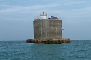
<span class="mw-page-title-main">Nab Tower</span> Anti-submarine tower off the Isle of Wight, England

The Nab Tower was a tower planned for anti-submarine protection in the Solent in World War I. It was sunk over the Nab rocks east of the Isle of Wight to replace a lightship after the war, and is a well-known landmark for sailors as it marks the deep-water eastern entry into the Solent.

<span class="mw-page-title-main">Start Point Lighthouse</span> Lighthouse in south Devon, England

Start Point lighthouse was built in 1836 to protect shipping off Start Point, Devon, England. Open to the public in summer months, it is owned and operated by Trinity House. It has been designated by English Heritage as a grade II listed building.
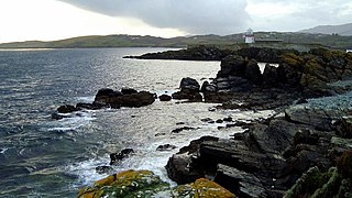
<span class="mw-page-title-main">Rotten Island Lighthouse</span> Lighthouse

Rotten Island lighthouse is a harbour light to light the passage from St. John's Point to inner channel and past the rocks to the anchorage within Killybegs Harbour, Donegal Bay, Ireland. It is operated by the Commissioners of Irish Lights.

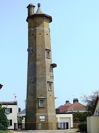
The High lighthouse or pillar lighthouse is one of three lighthouses in Burnham-on-Sea, Somerset, England. A Grade II listed building, it is no longer functional as a lighthouse and has been converted for use as a private dwelling.

<span class="mw-page-title-main">Burnham-on-Sea Low Lighthouse</span> Lighthouse

The Low Lighthouse is one of three historic lighthouses in Burnham-on-Sea, Somerset, England, and the only one of the three which is still active. It is a Grade II listed building and stands on the foreshore. First lit in 1832, the Low Lighthouse operated in conjunction with the (onshore) High Lighthouse for 137 years. Then, in 1969 the Low Lighthouse was deactivated; but later, in 1993, the Low Lighthouse was re-established and the High Lighthouse was instead decommissioned).

<span class="mw-page-title-main">Cape Moreton Light</span> Lighthouse in Queensland, Australia

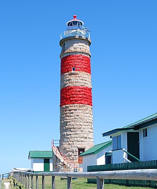
Cape Moreton Light, also listed as North Point Range Rear Light, is a heritage-listed active lighthouse located on Cape Moreton, a rocky headland located at the north eastern tip of Moreton Island, a large sand island on the eastern side of Moreton Bay, on the coast of South East Queensland, Australia. It marks the northern entrance to Moreton Bay and Brisbane and also serves as the rear light for the North Point Range. With its two distinctive red bands, it also serves as a daymark. It is the oldest lighthouse in Queensland, and the only one to be built by the New South Wales Government before the separation of Queensland, which took place in 1859. It is also the only lighthouse in Queensland to be built of stone.

<span class="mw-page-title-main">Needles Lighthouse</span> Lighthouse

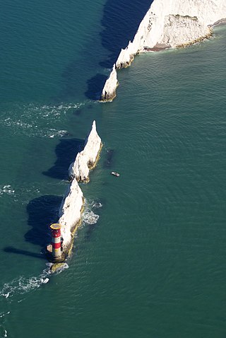
The Needles Lighthouse is an active 19th century lighthouse on the outermost of the chalk rocks at The Needles on the Isle of Wight in the United Kingdom, near sea level. Designed by James Walker, for Trinity House at a cost of £20,000. It was completed in 1859 from granite blocks, stands 33.25 metres (109.1 ft) high and is a circular tower with straight sides. It replaced an earlier light tower on top of a cliff overhanging Scratchell's Bay, which was first lit on 29 September 1786.

<span class="mw-page-title-main">Europa Point Lighthouse</span> Lighthouse on the southeastern tip of Gibraltar

The Europa Point Lighthouse, also referred to as the Trinity Lighthouse at Europa Point and the Victoria Tower or La Farola in Llanito, is a lighthouse at Europa Point, on the southeastern tip of the British Overseas Territory of Gibraltar, on the southern end of the Iberian Peninsula, at the entrance to the Mediterranean Sea.

<span class="mw-page-title-main">Anvil Point Lighthouse</span> Lighthouse

The Anvil Point Lighthouse is a fully-automated lighthouse located at Durlston Country Park near Swanage in Dorset, England. It is owned by Trinity House and currently operated as two holiday cottages.

<span class="mw-page-title-main">Bamburgh Lighthouse</span> Lighthouse

Bamburgh Lighthouse was built by Trinity House in 1910 to guide shipping both passing along the Northumberland coast and in the waters around the Farne Islands. It was extensively modernised in 1975 and is now monitored from the Trinity House Operations and Planning Centre in Harwich. Routine maintenance is carried out by a local attendant. It is the most northerly land-based lighthouse in England.

<span class="mw-page-title-main">Lowestoft Lighthouse</span> Lighthouse

Lowestoft Lighthouse is a lighthouse operated by Trinity House located to the north of the centre of Lowestoft in the English county of Suffolk. It stands on the North Sea coast close to Ness Point, the most easterly point in the United Kingdom. It acts as a warning light for shipping passing along the east coast and is the most easterly lighthouse in the UK.

<span class="mw-page-title-main">St Catherine's Lighthouse</span> Lighthouse on the southernmost point of the Isle of Wight, England

St Catherine's Lighthouse is a lighthouse located at St Catherine's Point at the southern tip of the Isle of Wight. It is one of the oldest lighthouse locations in Great Britain.

<span class="mw-page-title-main">Dungeness Lighthouse</span> Lighthouse

Dungeness Lighthouse on the Dungeness Headland started operation on 20 November 1961. Its construction was prompted by the building of Dungeness nuclear power station, which obscured the light of its predecessor which, though decommissioned, remains standing. The new lighthouse is constructed of precast concrete rings; its pattern of black and white bands is impregnated into the concrete. It remains in use today, monitored and controlled from the Trinity House Operations and Planning Centre at Harwich, Essex.

<span class="mw-page-title-main">Casquets lighthouses</span> Lighthouse

Casquets Lighthouse is an active lighthouse located on the rocky Les Casquets, Alderney, Channel Islands.

<span class="mw-page-title-main">Orfordness Lighthouse</span> Grade II listed lighthouse in the United kingdom

Orfordness Lighthouse was a lighthouse on Orford Ness, in Suffolk, England. The 30 metres (98 ft) tower was completed in 1792. Work began on demolition in July 2020, and was completed in August. The light had a range of 25 nautical miles. It was equipped with an AIS transmitter with MMSI 992351016.
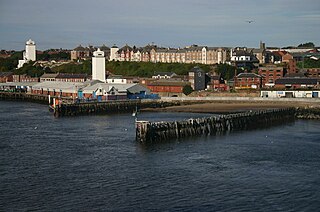
<span class="mw-page-title-main">Esteiro Lighthouse</span> Lighthouse

The Esteiro Lighthouse is an active Portuguese lighthouse located at Oeiras, about 10 km west of the centre of Lisbon, in parkland that also contains the National Stadium of Portugal. It is a rectangular masonry tower covered with white tiles. The south side has two red horizontal bands that serve as identification during daylight.

<span class="mw-page-title-main">Harwich High and Low Lighthouses</span> Pair of early 19th-century towers in Harwich, Essex

Harwich High and Low Lighthouses are a pair of early 19th-century towers in Harwich, Essex, which were built as leading lights to help guide vessels into the harbour. They replaced an earlier pair of lights established in the seventeenth century when Harwich was a key operational base for the Royal Navy.

<span class="mw-page-title-main">Lighthouses on Lundy</span>

Lundy has three lighthouses: a pair of active lights built in 1897 and an older lighthouse dating from 1797.

References

  1. Rowlett, Russ. "Lighthouses of Southern England". The Lighthouse Directory. University of North Carolina at Chapel Hill . Retrieved 2 May 2016.
  2. 1 2 3 Lighthouses Archived 1 February 2015 at the Wayback Machine , hurstcastle.co.uk, retrieved 18 April 2012
  3. 1 2 3 4 5 Woodman, Richard; Wilson, Jane (2002). The Lighthouses of Trinity House. Bradford-on-Avon, Wilts.: Thomas Reed. pp. 137–139.
  4. Walker, William (1864). Memoirs of the distinguished men of science of Great Britain living in the year 1807-1808 (2 ed.). p. 65.
  5. Falconer, William; Burney, William (1815). A New Universal Dictionary of the Marine. London: T. Cadell and W. Davies. p. 232.
  6. 1 2 Woodman, Richard; Wilson, Jane (2002). The Lighthouses of Trinity House. Bradford-on-Avon, Wilts.: Thomas Reed. pp. 22–29.
  7. "Lighthouse management : the report of the Royal Commissioners on Lights, Buoys, and Beacons, 1861, examined and refuted Vol. 2". pp. 82–83.
  8. Sailing Directions for the English Channel: Part 1. Washington: Government Printing Office. 1872. p. 119.
  9. The English channel pilot. London: Charles Wilson. 1878. p. 53.
  10. 1 2 3 Photograph of diagrams from the ALK Museum in Hurst Castle
  11. 1 2 3 Kitchin, Darcy Butterworth (1898). The Solent Chart Book. London: Swan Sonnenschein & Co. p. 60. Retrieved 23 July 2019.
  12. "Photograph of the lenses". Archived from the original on 24 September 2015. Retrieved 23 February 2019.
  13. "Lighthouse" in Encyclopaedia Britannica, 14th edition, volume 15.
  14. "Ocean Navigation". Report of the XIII International Congress of Navigation: 6. 1923.
  15. 1 2 3 "Hurst Point Lighthouse". Trinity House. Archived from the original on 22 July 2012.
  16. "Hurst Point". Lighthouses of England. Archived from the original on 24 September 2015. Retrieved 23 February 2019.
  17. "The Association of Lighthouse Keepers". Hurst Castle. Retrieved 23 July 2019.
  18. Photo