Portishead Point Lighthouse

Last updated

Portishead Point Lighthouse
Battery Point
Portishead Lighthouse.jpg
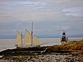
Portishead Point Lighthouse also known as Battery Point Lighthouse
Portishead Point Lighthouse
Location Portishead
Somerset
England
Coordinates 51°29′41″N2°46′25″W / 51.494626°N 2.773586°W / 51.494626; -2.773586 Coordinates: 51°29′41″N2°46′25″W / 51.494626°N 2.773586°W / 51.494626; -2.773586
Tower
Constructed1931
Foundationconcrete base
Constructionmetal skeletal tower
Height9 metres (30 ft)
Shapesquare pyramidal tower enclosed with balcony and light
Markingsblack tower, white basement
OperatorBristol Port Company [1]
Light
Focal height9 metres (30 ft)
Lens 4th-order dioptric [2]
Range16 nautical miles (30 km; 18 mi)
Characteristic Q (3) W 10s.

Portishead Point Lighthouse, which is more commonly known as Battery Point Lighthouse, in Portishead, Somerset, England was built in 1931.

Contents

History

The 9-metre-high (30 ft) lighthouse was built at Battery Point by the Chance Brothers of Smethwick. It was established in 1931 as an unwatched automatic light. [3] It consists of a black metal pyramid on a concrete base. [4]

Originally it had been intended to provide Portishead Point with a diaphone fog signal, but in response to local unrest at the prospect the decision was taken to commission a fog bell instead. [2] The two tonne bell was cast by Gillett & Johnston of Croydon in 1938, [5] and installed the following year. [2] Due to structural concerns the bell was removed in 1998; later, following public campaigning for restoration, the bell was acquired by Portishead Town Council and returned to the town in 2012. [6] It is installed in Wyndham Way close to the High Street. [7]

The lighthouse is maintained by the Bristol Port Company. [8] The light was refurbished in 2012. [9]

See also

Related Research Articles

<span class="mw-page-title-main">Eddystone Lighthouse</span> Lighthouse in Cornwall, England

The Eddystone Lighthouse is a lighthouse that is located on the Eddystone Rocks, 9 statute miles (14 km) south of Rame Head in Cornwall, England. The rocks are submerged below the surface of the sea and are composed of Precambrian gneiss.

Weston-super-Mare, also known simply as Weston, is a seaside town in the North Somerset unitary area in the county of Somerset, England. It lies by the Bristol Channel 20 miles (32 km) south-west of Bristol between Worlebury Hill and Bleadon Hill. It includes the suburbs of Mead Vale, Milton, Oldmixon, West Wick, Worlebury, Uphill and Worle. Its population at the 2021 census was 82,418. Since 1983, Weston has been twinned with Hildesheim in Germany.

<span class="mw-page-title-main">North Somerset</span> Non-metropolitan district in England

North Somerset is a unitary district in Somerset, South West England. Whilst its area covers part of the ceremonial county of Somerset, it is administered independently of the non-metropolitan county. Its administrative headquarters is in the town hall in Weston-super-Mare.

<span class="mw-page-title-main">Watchet</span> Human settlement in England

Watchet is a harbour town, civil parish and electoral ward in the county of Somerset, England, with a population in 2011 of 3,785. It is situated 15 miles (24 km) west of Bridgwater, 15 miles (24 km) north-west of Taunton, and 9 miles (14 km) east of Minehead. The town lies at the mouth of the Washford River on Bridgwater Bay, part of the Bristol Channel, and on the edge of Exmoor National Park.

<span class="mw-page-title-main">Portishead, Somerset</span> Town in Somerset, England

Portishead is a town on the Severn Estuary within the unitary district of North Somerset, which falls within the ceremonial county of Somerset, England. The town is 8 miles to the west of Bristol and has a population of more than 25,000.

<span class="mw-page-title-main">Nab Tower</span> Anti-submarine tower off the Isle of Wight, England

The Nab Tower was a tower planned for anti-submarine protection in the Solent in World War I. It was sunk over the Nab rocks east of the Isle of Wight to replace a lightship after the war, and is a well-known landmark for sailors as it marks the deep-water eastern entry into the Solent.

<span class="mw-page-title-main">Roker</span> Suburb of Sunderland, England

Roker is a tourist resort and affluent area of Sunderland, North East England, bounded on the south by the River Wear and Monkwearmouth, on the east by the North Sea, to the west by Fulwell and on the north by Seaburn. It is administered as part of the City of Sunderland and lies within historic County Durham.

<span class="mw-page-title-main">Portishead and North Weston</span> Human settlement in England

Portishead or Portishead and North Weston is a civil parish in North Somerset, England. The parish includes the coastal town of Portishead along with the village of North Weston. The 2011 census gave the population as 23,699. As of 2017 however, the population number is estimated to be well over 25,000 with another 8,000 people expected by 2026.

<span class="mw-page-title-main">Portishead Town F.C.</span> Association football club in England

Portishead Town Football Club, formerly Portishead A.F.C., are a football club based in Portishead, North Somerset, England founded in 1912. The men's first team are currently members of the Western League Division One and the Ladies first team are members of the The FA Women's National League South West Division 1. The club is also home to nearly 900 Junior players aged between 5-16 as part of a merger between other Portishead junior football teams. The club is affiliated to the Somerset County FA.

<span class="mw-page-title-main">Portishead Railway</span>

The Portishead Railway is a branch line railway running from Portishead in North Somerset to the main line immediately west of Bristol, England. It was constructed by the Bristol & Portishead Pier and Railway Company, but it was always operated by its main line neighbour, and was more usually thought of as the Portishead branch or the Portishead railway.

<span class="mw-page-title-main">Godrevy Lighthouse</span> Lighthouse

Godrevy Lighthouse was built in 1858–1859 on Godrevy Island in St Ives Bay, Cornwall. Standing approximately 300 metres (980 ft) off Godrevy Head, it marks the Stones reef, which has been a hazard to shipping for centuries.

<span class="mw-page-title-main">Parson Street railway station</span> Railway station in Bristol, England

Parson Street railway station serves the western end of Bedminster in Bristol, England. It also serves other surrounding suburbs including Bishopsworth, Ashton Vale and Ashton Gate, along with Bristol City FC. It is 2 miles (3.2 km) from Bristol Temple Meads, and 120 miles (193 km) from London Paddington. Its three letter station code is PSN. It was opened in 1927 by the Great Western Railway, and was rebuilt in 1933. The station, which has two through-lines and two platforms, plus one freight line for traffic on the Portishead Branch Line, has minimal facilities. As of 2020, it is managed by Great Western Railway, which is the sixth company to be responsible for the station, and the third franchise since privatisation in 1997. They provide all train services at the station, mainly an hourly service between Bristol Parkway and Weston-super-Mare.

<span class="mw-page-title-main">Bull Point Lighthouse</span> Lighthouse on the coast of Devon, England

Bull Point Lighthouse is a lighthouse on Bull Point, about one mile (1.6 km) north of the village of Mortehoe, on the northern coast of Devon, England. The lighthouse provides a visual aid to the villages of Mortehoe, Woolacombe and Ilfracombe, and warns of the inhospitable and rocky coast that lines the area.

<span class="mw-page-title-main">Transport in Somerset</span> Overview of transport in Somerset

The earliest known infrastructure for transport in Somerset is a series of wooden trackways laid across the Somerset Levels, an area of low-lying marshy ground. To the west of this district lies the Bristol Channel, while the other boundaries of the county of Somerset are along chains of hills that were once exploited for their mineral deposits. These natural features have all influenced the evolution of the transport network. Roads and railways either followed the hills, or needed causeways to cross the Levels. Harbours were developed, rivers improved, and linked to sources of traffic by canals. Railways were constructed throughout the area, influenced by the needs of the city of Bristol, which lies just to the north of Somerset, and to link the ports of the far south-west with the rest of England.

<span class="mw-page-title-main">MetroWest (Bristol)</span> Project to improve the rail services in Bristol

MetroWest, formerly known as the Greater Bristol Metro, is a project to improve the rail services in Bristol, England, and the surrounding region. It was first proposed at First Great Western's Stakeholder Event in March 2008. The aim of the project is to develop half-hourly services through central Bristol which will also serve the surrounding West of England region. Transport campaigning groups Friends of Suburban Bristol Railways (FoSBR) and Transport for Greater Bristol are actively supporting the proposal, as are the three unitary authorities under the West of England Combined Authority and North Somerset Council.

<span class="mw-page-title-main">Needles Lighthouse</span> Lighthouse

The Needles Lighthouse is an active 19th century lighthouse on the outermost of the chalk rocks at The Needles on the Isle of Wight in the United Kingdom, near sea level. Designed by James Walker, for Trinity House at a cost of £20,000. It was completed in 1859 from granite blocks, stands 33.25 metres (109.1 ft) high and is a circular tower with straight sides. It replaced an earlier light tower on top of a cliff overhanging Scratchell's Bay, which was first lit on 29 September 1786.

<span class="mw-page-title-main">Black Nore Lighthouse</span> Lighthouse in Somerset, England

Black Nore Lighthouse at Portishead, Somerset, England, was built in 1894. It is a Grade II listed building.

<span class="mw-page-title-main">Lowestoft Lighthouse</span> Lighthouse

Lowestoft Lighthouse is a lighthouse operated by Trinity House located to the north of the centre of Lowestoft in the English county of Suffolk. It stands on the North Sea coast close to Ness Point, the most easterly point in the United Kingdom. It acts as a warning light for shipping passing along the east coast and is the most easterly lighthouse in the UK.

<span class="mw-page-title-main">National Nautical School</span>

The National Nautical School in Portishead, within the English county of Somerset, was created in 1869 for destitute and neglected boys of Bristol. It was based on HMS Formidable moored off the shore from 1870 until 1906. It then used a purpose built facility nearby until its closure in 1982.

<span class="mw-page-title-main">Lighthouses on Lundy</span>

The isle of Lundy has three lighthouses: a pair of active lights built in 1897 and an older lighthouse dating from 1797.

References

  1. Rowlett, Russ. "Lighthouses of Western England". The Lighthouse Directory. University of North Carolina at Chapel Hill . Retrieved 28 April 2016.
  2. 1 2 3 Cooper, F. W. (1979). Twenty Years in Lighthouses (PDF). United States Lighthouse Society. pp. 100–101. Retrieved 13 March 2019.
  3. "Progress in Illuminating Engineering". The Illuminating Engineer (The Journal of Good Lighting). 24: 307. December 1931.
  4. "Portishead Point Lighthouse". Worldwide lighthouses. Archived from the original on 4 March 2016. Retrieved 23 September 2012.
  5. "Battery Point Lighthouse" (PDF). Portishead and North Weston Town Council Newsletter. September 2010. Archived from the original on 8 June 2015. Retrieved 23 September 2012.
  6. "Old lighthouse bell hasn't tolled yet for town". This is Bristol. Archived from the original on 5 May 2013. Retrieved 23 September 2012.
  7. Fowler, Tracey (17 April 2012). "Lighthouse bell to return home". Weston, Worle and Somerset Mercury. Archived from the original on 3 March 2016. Retrieved 23 September 2012.
  8. "Portishead Point A5484 – Bristol Channel, UK". The Lighthouse Duo. Archived from the original on 9 September 2010. Retrieved 1 December 2009.
  9. "Notice to marners (No 32 of 2012) Portishead light refurbishment". The BRistol Port Company. Retrieved 23 September 2012.[ permanent dead link ]