Needles Lighthouse

Last updated • 5 min readFrom Wikipedia, The Free Encyclopedia

Needles Lighthouse
The Needles, Isle of Wight, England-2Oct2011.jpg
Aerial view of Needles Lighthouse
Needles Lighthouse
Location Alum Bay
Isle of Wight
England
OS grid SZ2895484811
Coordinates 50°39′44.2″N1°35′30.5″W / 50.662278°N 1.591806°W / 50.662278; -1.591806
Tower
Constructed1786 (first)
Built by James Walker   OOjs UI icon edit-ltr-progressive.svg
Constructiongranite tower
Automated1994
Height31 m (102 ft)
Shapecylindrical tower with lantern and helipad above lantern
Markingstower with red and white bands
OperatorTrinity House [1] [2]
Heritage Grade II listed building   OOjs UI icon edit-ltr-progressive.svg
Fog signal two blasts every 30s.
Light
First lit1859 (current)
Focal height24 m (79 ft)
Lens2nd order 700mm fixed lens
Intensitywhite: 12,300 candela
red (intensified): 3,950 candela
red: 1,800 candela
green 2,860 candela
Rangewhite and red (intensified): 17 nmi (31 km; 20 mi)
red and green: 14 nmi (26 km; 16 mi)
Characteristic Oc (2) WRG 20s.

The Needles Lighthouse is an active 19th century lighthouse on the outermost of the chalk rocks at The Needles on the Isle of Wight in the United Kingdom, near sea level. Designed by James Walker, for Trinity House at a cost of £20,000, it was completed in 1859 from granite blocks. It stands 33.25 metres (109.1 ft) high and is a circular tower with straight sides. It replaced an earlier light tower on top of a cliff overhanging Scratchell's Bay, which was first lit on 29 September 1786.

Contents

The first lighthouse

In 1781 a group of merchants and ship owners petitioned Trinity House for navigation lights to be provided around the western approaches to the Solent. The response was positive, but it was not until 1785 that construction began, on three new lighthouses: one on the clifftop above the Needles, one on Hurst Point and one on St Catherine's Down (which was left unfinished and never lit); all three were designed by Richard Jupp. [3]

From September the following year the Needles light was operational. It was described as 'a low truncated cone, situated on the highest point of the lofty cliffs [...], and near the edge of the cliff, forming the western extremity of the island'; [4] however, its height of 496 feet (151 m) above sea level meant it was often obscured by fog and sea mists, a problem that eventually led to its replacement some 70 years later. [3] Illumination was provided by 13 Argand lamps with parabolic reflectors; [5] The light initially shone white, but on 1 March 1840 it was altered to display a red light, so as not to be confused with the newly erected lighthouse on St Catherine's Point. [6] Prior to its decommissioning, the light shone red to seaward but white from St Alban's Head to Hurst Point. [7]

The current lighthouse

History

The Needles c.1890 The Needles, I., Isle of Wight, England-LCCN2002708245.jpg
The Needles c.1890

Before work could begin on the new tower, a sizeable section of rock was cut away to provide a level base. Tunnels were also excavated within the rock behind the tower to provide rooms for storage. An oil burner, with four concentric wicks, provided the light source atop the new tower; it was set within a large (first-order) fixed catadioptric optic provided by Henry-Lepaute of Paris. [5] Keepers' accommodation was provided within the lighthouse, which was to be staffed by a team of three keepers (of whom, at any one time, two would be on duty in the tower and one on shore leave, by monthly rotation).

The lighthouse was first lit on 1 January 1859. [5] It initially displayed a fixed red light with a white sector indicating a clear approach running south of Durlestone Head and past a pair of sandbanks: South-west Shingles and Dolphin Bank. [7] Later a narrow white sector marked the approach from the north-east past Warden Ledge; [8] By 1884 a further (green) sector had been added and the light made occulting. [9]

The tower itself had initially been left as plain granite 'not coated nor coloured', [5] but in 1886, so as to make it stand out more prominently against the cliffs during the day, it was painted with a broad black stripe around the middle; the metalwork of the lantern was also painted black, and dark curtains were hung within the glass when the lamp was not in use. [10]

In 1922, a more powerful incandescent paraffin vapour burner was installed, which increased the intensity of the light from 35,000 to 500,000 candlepower. [11]

During the Second World War, the lantern, lens and lamp were badly damaged in a German aerial attack. After the war the lighthouse was repaired: in 1946, a new electric light was installed (powered by diesel generators providing 100 volt direct current); then, in 1948, a new, second-order fixed catadioptric optic was made for the lighthouse by Chance Brothers, to replace the one damaged in the war. [12]

The lighthouse with helipad. The Needles Lighthouse. Isle of Wight.. - panoramio.jpg
The lighthouse with helipad.

Before automation, the lighthouse was staffed by a three-man crew operating a 24-hour watch, serving one month on / one month off, living in rudimentary conditions in three levels below the light. [13] In 1987, a helipad was added to the top of the lighthouse. By the early 1990s the Needles was the last Trinity House lighthouse to be powered by 100 V DC electricity from its own generators. [3] Before it could become fully automated, a submarine power cable had to be laid, bringing 240 V mains electricity to the lighthouse from the island. By the time the last keepers left on 8 December 1994 the Needles was one of the last three remaining manned rock lighthouses in England and Wales. [3]

Fog signalling apparatus

One of the sets of supertyfon horns formerly installed on the lighthouse. Needles Lighthouse fog signal bank.jpg
One of the sets of supertyfon horns formerly installed on the lighthouse.

Initially the lighthouse had been provided with a 3 cwt bell, hung beneath the gallery, to serve as a fog signal. [5] The bell was struck once every 7.5 seconds; [14] it was sounded by a clockwork mechanism, but using it was 'an arduous piece of work, for the driving weights are very heavy and need to be frequently wound up'. [15]

In 1906, a reed fog signal was installed, together with a pair of oil engines in the basement of the tower to provide compressed air; it sounded from three acoustic horns which protruded through the roof of the lantern, [16] giving one long blast every fifteen seconds. [17] In 1946, as part of the electrification of the light, Gardner diesel-driven generators replaced the oil engines; these also powered compressors for the fog horn, which were installed along with a set of air tanks just below the lantern room. [16]

By 1964, [18] the reeds had been replaced with two sets of 'supertyfon' air horns, mounted on the parapet surrounding the lantern, which sounded twice every 30 seconds. [19] In 1994, these were in turn replaced by electric emitters as part of the automation process. [16]

Present day

Today the main lamp is a 1500W bulb; the fixed optic with its coloured sectors remains in use as of 2019. [20] Due to the condition of the chalk strata on which the lighthouse was built, in April 2010 a £500,000 underpinning project was announced, designed to stop the lighthouse falling into the sea. [21] Over a 12-week period from early June, civil marine contractors Nuttall John Martin excavated a trench around the base of the lighthouse, to install a ring of stabilising posts, reinforced with concrete. [22]

See also

Related Research Articles

<span class="mw-page-title-main">Longships Lighthouse</span> Lighthouse in England

Longships Lighthouse is an active 19th-century lighthouse about 1.25 mi (2.0 km) off the coast of Land's End in Cornwall, England. It is the second lighthouse to be built on Carn Bras, the highest of the Longships islets which rises 39 feet (12 m) above high water level. In 1988 the lighthouse was automated, and the keepers withdrawn. It is now remotely monitored from the Trinity House Operations & Planning Centre in Harwich, Essex.

<span class="mw-page-title-main">Eddystone Lighthouse</span> Lighthouse in Cornwall, England

The Eddystone Lighthouse is a lighthouse that is located on the Eddystone Rocks, 9 statute miles (14 km) south of Rame Head in Cornwall, England. The rocks are submerged below the surface of the sea and are composed of Precambrian gneiss.

<span class="mw-page-title-main">Bishop Rock</span> Skerry in the Atlantic Ocean off the coast of Cornwall, England

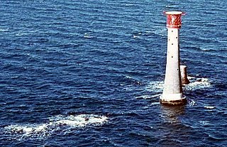
The Bishop Rock is a skerry off the British coast in the northern Atlantic Ocean known for its lighthouse. It is in the westernmost part of the Isles of Scilly, an archipelago 45 kilometres off the southwestern tip of the Cornish peninsula of Great Britain. The Guinness Book of Records lists it as the world's smallest island with a building on it.

<span class="mw-page-title-main">Nab Tower</span> Anti-submarine tower off the Isle of Wight, England

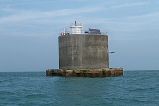
The Nab Tower is a tower originally planned for anti-submarine protection in the English Channel in World War I. It was sunk over the Nab rocks east of the Isle of Wight to replace a lightship after the war, and is a well-known landmark for sailors as it marks the deep-water eastern entry into the Solent.

<span class="mw-page-title-main">Souter Lighthouse</span> Lighthouse in England

Souter Lighthouse is a lighthouse located to the North of Whitburn, South Tyneside, England.. Souter Point was the first lighthouse in the world to be actually designed and built specifically to use alternating electric current, the most advanced lighthouse technology of its day. The light was generated by a carbon arc lamp: first lit on 11 January 1871, it was described at the time as 'without doubt one of the most powerful lights in the world'.

<span class="mw-page-title-main">Lizard Lighthouse</span> Lighthouse on the south coast of Cornwall, England

The Lizard Lighthouse is a lighthouse at Lizard Point, Cornwall, England, built to guide vessels passing through the English Channel. It was often the welcoming beacon to persons returning to England, where on a clear night, the reflected light could be seen 100 mi (160 km) away.

<span class="mw-page-title-main">Beachy Head Lighthouse</span> Lighthouse at Beachy Head, East Sussex, England

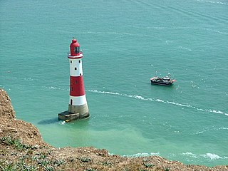
Beachy Head Lighthouse is a lighthouse located in the English Channel below the cliffs of Beachy Head in East Sussex. It is 33 m (108 ft) in height and became operational in October 1902. It was the last traditional-style 'rock tower' to be built by Trinity House.

<span class="mw-page-title-main">South Foreland Lighthouses</span> Pair of lighthouses in England, United Kingdom

South Foreland Lighthouses are a pair of Victorian lighthouses on the South Foreland in St. Margaret's Bay, Dover, Kent, England, used to warn ships approaching the nearby Goodwin Sands. There has been a pair of lighthouses at South Foreland since at least the 1630s. Even after the decommissioning of the Lower Lighthouse the pair continued to be used as leading marks, with Admiralty charts into the 20th century indicating that the 'Lighthouses in line lead south of the Goodwin Sands'.

<span class="mw-page-title-main">Start Point Lighthouse</span> Lighthouse in south Devon, England

Start Point lighthouse was built in 1836 to protect shipping off Start Point, Devon, England. Open to the public in summer months, it is owned and operated by Trinity House. It has been designated by English Heritage as a grade II listed building.

<span class="mw-page-title-main">Bull Point Lighthouse</span> Lighthouse on the coast of Devon, England

Bull Point Lighthouse is a lighthouse on Bull Point, about one mile (1.6 km) north of the village of Mortehoe, on the northern coast of Devon, England. The lighthouse provides a visual aid to the villages of Mortehoe, Woolacombe and Ilfracombe, and warns of the inhospitable and rocky coast that lines the area.

<span class="mw-page-title-main">Hurst Point Lighthouse</span> Lighthouse in Hampshire, England

Hurst Point Lighthouse is located at Hurst Point in the English county of Hampshire, and guides vessels through the western approaches to the Solent.

<span class="mw-page-title-main">Hartland Point Lighthouse</span> Lighthouse in Devon, England

Hartland Point Lighthouse is a Grade II listed building at Hartland Point, Devon, England. The point marks the western limit of the Bristol Channel with the Atlantic Ocean continuing to the west. Trinity House, the lighthouse authority for England and Wales, have a lighthouse on the tip of the peninsula.

<span class="mw-page-title-main">Europa Point Lighthouse</span> Lighthouse on the southeastern tip of Gibraltar

The Europa Point Lighthouse, also referred to as the Trinity Lighthouse at Europa Point and the Victoria Tower or La Farola in Llanito, is a lighthouse at Europa Point, on the southeastern tip of the British Overseas Territory of Gibraltar, on the southern end of the Iberian Peninsula, at the entrance to the Mediterranean Sea.

<span class="mw-page-title-main">Whitby Lighthouse</span> Grade II listed lighthouse in the United Kingdom

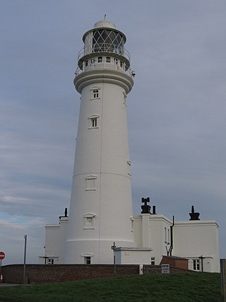
Whitby Lighthouse is a lighthouse operated by Trinity House. It is on Ling Hill, on the coast to the southeast of Whitby, beyond Saltwick Bay. To distinguish it from the two lighthouses in Whitby itself it is sometimes known as Whitby High lighthouse

<span class="mw-page-title-main">Lowestoft Lighthouse</span> Lighthouse in Lowestoft, England

Lowestoft Lighthouse is a lighthouse operated by Trinity House located to the north of the centre of Lowestoft in the English county of Suffolk. It stands on the North Sea coast close to Ness Point, the most easterly point in the United Kingdom. It acts as a warning light for shipping passing along the east coast and is the most easterly lighthouse in the UK.

<span class="mw-page-title-main">St Catherine's Lighthouse</span> Lighthouse on the southernmost point of the Isle of Wight, England

St Catherine's Lighthouse is a lighthouse located at St Catherine's Point at the southern tip of the Isle of Wight. It is one of the oldest lighthouse locations in Great Britain.

<span class="mw-page-title-main">Flamborough Head Lighthouse</span> Lighthouse

Flamborough Head Lighthouse is an active lighthouse located at Flamborough, East Riding of Yorkshire. England. Flamborough Head Lighthouse acts as a waypoint for passing deep sea vessels and coastal traffic, and marks Flamborough Head for vessels heading towards Scarborough and Bridlington.

<span class="mw-page-title-main">Dungeness Lighthouse</span> Lighthouse

Dungeness Lighthouse on the Dungeness Headland started operation on 20 November 1961. Its construction was prompted by the building of Dungeness nuclear power station, which obscured the light of its predecessor which, though decommissioned, remains standing. The new lighthouse is constructed of precast concrete rings; its pattern of black and white bands is impregnated into the concrete. It remains in use today, monitored and controlled from the Trinity House Operations and Planning Centre at Harwich, Essex.

<span class="mw-page-title-main">Casquets lighthouses</span> Lighthouse

Casquets Lighthouse is an active lighthouse located on the rocky Les Casquets, Alderney, Channel Islands.

<span class="mw-page-title-main">Lighthouses on Lundy</span>

The isle of Lundy has three lighthouses: a pair of active lights built in 1897 and an older lighthouse dating from 1797.

References

  1. Rowlett, Russ. "Lighthouses of Southern England". The Lighthouse Directory. University of North Carolina at Chapel Hill . Retrieved 3 May 2016.
  2. Needles Lighthouse Trinity House. Retrieved 3 May 2016
  3. 1 2 3 4 "Needles Lighthouse". Trinity House. n.d. Archived from the original on 2 May 2010. Retrieved 25 May 2010.
  4. Brettell, Thomas (1844). Handbook to the Isle of Wight (3rd ed.). London: John Mitchell.
  5. 1 2 3 4 5 "Lighthouse management : the report of the Royal Commissioners on Lights, Buoys, and Beacons, 1861, examined and refuted Vol. 2". p. 82.
  6. London Gazette, Issue 19821, Page 243, 7 February 1840
  7. 1 2 Hobbs, J. S. (1859). The Bristol Channel Pilot: from The Downs to Bristol. London: Charles Wilson. p. 36.
  8. The English Channel Pilot. London: Charles Wilson. 1878. p. 54.
  9. Edwards, E. Price (1884). Our Seamarks: a plain account of the Lighthouses, Lightships, Beacons, Buoys, and Fog-signals maintained on our Coasts. London: Longmans, Green & co. p. 184. Retrieved 25 February 2019.
  10. London Gazette, Issue 25564, Page 1035, 2 March 1886
  11. "Needles Light To Be Made More Powerful". The Nautical Gazette. 103 (11): 340. 9 September 1922.
  12. "By Chance". Magazine of the Future. III (2): 27. March 1948.
  13. Nowicka, Helen (15 August 1993). "Last one out, leave the light on: The Needles lighthouse is to lose its keepers as manning is phased out around Britain". The Independent. London. Archived from the original on 7 November 2012. Retrieved 25 May 2010.
  14. Potter, J. D. (1900). The Channel Pilot, Part 1. London: Hydrographic Department. p. 206.
  15. "Lighthouse Life". The London Magazine. VII (42): 537. January 1902.
  16. 1 2 3 Renton, Alan (2001). Lost Sounds: The Story of Coast Fog Signals. Caithness, Scotland: Whittles.
  17. British Islands Pilot, volume I (2nd ed.). Washington DC: Government Printing Office. 1920. p. 240.
  18. Admiralty Chart, corrected up to 1964.
  19. Whitehead, John D.; Edwards, Marie. "St Catherine's Point". Wight Life.
  20. Needles Lighthouse Trinity House. Retrieved 1 May 2019
  21. "Rescue to save Needles lighthouse landmark". The Mirror. 30 April 2010. Archived from the original on 20 November 2011. Retrieved 25 May 2010.
  22. "Work to start on crumbling lighthouse". Isle of Wight County Press. 28 April 2010. Archived from the original on 1 May 2010. Retrieved 25 May 2010.