South Walls

Last updated

South Walls
Scots nameSooth Waas
Old Norse nameVágaland/Vágar
Lighthouse on Orkney (4014902776).jpg
Cantick Head lighthouse on South Walls
Location
Orkney Islands UK relief location map.jpg
Red pog.svg
South Walls
South Walls shown within Orkney
OS grid reference ND304895
Coordinates 58°47′16″N3°12′18″W / 58.78788°N 3.2049°W / 58.78788; -3.2049
Physical geography
Island group Orkney
Area1,100 ha (4.2 sq mi) [1]
Area rank47 [2]
Highest elevation57 m (187 ft)
Administration
Sovereign state United Kingdom
Country Scotland
Council area Orkney Islands
Lymphad3.svg
References [3] [4] [5] [6] [7]

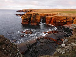
South Walls is a tidal island or peninsula at the southern end of Hoy in Orkney, Scotland. It is connected to the main body of Hoy, and to the district of North Walls, by a thin neck of land known as the Ayre. Its largest settlement is Longhope, which lies on a long natural harbour of the same name. [8] [9] Both North and South Walls belong to the civil parish of Walls and Flotta. [10]

Contents

South Walls is a popular stopping off place for barnacle geese.

Etymology

The Norse name of Vágaland, meaning "land of bays" applied to both what is now South Walls and the southern portion of nearby Hoy. [11] Over time this became Scots : Wais [12] (variously spelled) for the whole area and Scots : Sooth Waas meaning "southern bays" for the island. [7] As for Kirkwall, early cartographers assumed "waa" was a local pronunciation of "wall", hence the modern name. [7] [13]

Geography and geology

South Walls, like most of the Orkney archipelago, is made up of old red sandstone, with the Rousay flagstone group predominating. [14] It is more or less oval in shape, although there is a small promontory called Cantick Head in the southeast, overlooking Kirk Hope. It is separated from Hoy by the inlet of Longhope. The body of water south of the Ayre is known as Aith Hope.

Although it is clear that South Walls is inhabited as it was not listed as an inhabited island by the census [15] [16] no reliable estimate of the current population is available.

Status as an island or peninsula

In the past various descriptions suggest that South Walls was usually considered to be an island.

The Vision of Britain map of 1856 shows a drying gap between the islands of Hoy and South Walls. [21]

The Ayre, with North Walls beyond Longhope, heading down to The Ayre - geograph.org.uk - 2534689.jpg
The Ayre, with North Walls beyond

A road linking South Walls to Hoy was constructed towards the end of the 19th century. Prior to that time it had only been accessible by land across the shingle beach of the Ayre at low tide. [22] Its status is now considered by some writers as a peninsula attached to Hoy and by others as still being an island. Some examples are given below.

Neither the 2001 or 2011 censuses mention South Walls in their lists of inhabited islands. [15] [16] In 2001 the General Register Office for Scotland defined an island as "a mass of land surrounded by water, separate from the Scottish mainland" and although the inclusion of islands linked man-made constructions is not clear from this definition in practice they list several separately that are joined to one another by bridges and causeways such as South Ronaldsay in Orkney or are tidal islands such as Eilean Shona and Erraid in the Hebrides.

South Walls is listed in Livingstone's comprehensive Scottish island tables [1] but the Gazetteer for Scotland states that it is "a peninsula, sometimes described as an island." [23] Haswell-Smith states that South Walls "was an island" until the causeway over the Ayre was constructed. [3] For similar reasons he excludes Skye amongst others that are considered by others as having island status. [24] [15]

History

Norse period

South Walls features fairly prominently in the Norse period, partly because it was the first landfall when sailing from west Caithness or Sutherland. It and North Walls were known to the Norsemen as Vágaland, the land of voes or bays. [11]

South Walls also played a crucial role in the Christianisation of Orkney. Although Christianity in the islands predated the Norse by a number of years, the Norse often remained pagan. Olaf Tryggvasson, King of Norway forced the Earl of Orkney, Sigurd Hloðvisson to be baptised at South Walls. [25] Earl Sigurd accepted, and remained a nominal Christian the rest of his life. However, he did so under duress - King Olaf had many valas (Norse shamans) executed by being tied and left on a skerry at ebb. This was a long and terrible wait for death, and perhaps Earl Sigurd expected a similar fate.

17th century

Walter Stewart's "Chorographic Description" of Orkney and Shetland says of South Walls:

Its south coast is gnawed at as if by a rabid dog by the Pentland Firth; its waves like so many teeth are strongly resisted by the very high and hard cliffs which stretch out before this island, and blunt the bite. It enjoys from and in itself quite a good production of crops, pastures, fish sea- and land-birds, and ponies. There are very many buildings on it and very many spirited inhabitants, in particular a dwelling called Snelsetter to the south, and one called Melsetter to the west. It also has an anchorage for ships not far from Snelsetter, quite commodious. [18]

Modern history

Hackness martello tower, one of a pair on either side of Longhope bay, built in 1813-14 Hacknessmartello.jpg
Hackness martello tower, one of a pair on either side of Longhope bay, built in 1813-14

Overlooking Longhope in the north east is Hackness Martello Tower and Battery. The tower, together with another on the north side at Crockness on Hoy, was built in 1815 to protect British ships in the bay of Longhope against attack by American and French privateers, during the Napoleonic Wars, while they waited for a Royal Navy escort on their journey to Baltic ports. [27] The towers were rearmed for World War I. Hackness Martello Tower and Battery is in the care of Historic Environment Scotland. [26]

Cantick Head is well known for its lighthouse designed and built by David and Thomas Stevenson and first lit in July 1858 and automated in 1991. [28]

South Walls has substantial remains from the Second World War, when Scapa Flow was used as a Royal Navy base.

Longhope lifeboat

A lifeboat has been stationed on Hoy since 1874, at first housed in a prominent stone building close to the west end of the causeway that links the two islands of Hoy and South Walls. In 2000 an Arun-class lifeboat, Sir Max Aitken II became the Longhope lifeboat. This class was designed to stay permanently afloat, and the decision was taken to move her to purpose-built moorings at Longhope pier. The lifeboats that have served here since have also been stationed at Longhope, including the current vessel the Helen Comrie (a Tamar-class lifeboat) and her predecessor The Queen Mother, which was based here between 2004 and 2006. A station has been built where the lifeboat is moored at Longhope which is also the main harbour for boats to and from the island. [29] [4]

Natural History

The Candle stack and cliffs within the Hill of White Hamars nature reserve The Candle, Snelsetter - geograph.org.uk - 1081363.jpg
The Candle stack and cliffs within the Hill of White Hamars nature reserve

Barnacle geese regularly over-winter on South Walls with numbers often exceeding 1500. [30] Many species of seabirds nest on the cliffs including razorbills, fulmar and guillemots. Butterflies such as meadow browns and common blues can be seen in the summer. The Scottish primrose can be found at the Scottish Wildlife Trust nature reserve at Hill of White Hamars on the south coast. [7] [31]

Footnotes

  1. 1 2 Rick Livingstone’s Tables of the Islands of Scotland (pdf) Argyll Yacht Charters. Retrieved 12 Dec 2011.
  2. Area and population ranks: there are c.300 islands over 20ha in extent and 93 permanently inhabited islands were listed in the 2011 census.
  3. 1 2 Haswell-Smith (2006) p. 346
  4. 1 2 Ordnance Survey. OS Maps Online (Map). 1:25,000. Leisure.
  5. Anderson, Joseph (Ed.) (1893) Orkneyinga Saga. Translated by Jón A. Hjaltalin & Gilbert Goudie. Edinburgh. James Thin and Mercat Press (1990 reprint). ISBN   0-901824-25-9
  6. Pedersen, Roy (January 1992) Orkneyjar ok Katanes (map, Inverness, Nevis Print)
  7. 1 2 3 4 "South Walls: Ayyre to Cantick Head". (2017) Stromness Museum. Orkney Islands Council. pp. 2-3
  8. "North Walls". Gazetteer for Scotland . Retrieved 9 February 2024.
  9. "South Walls". Gazetteer for Scotland . Retrieved 9 February 2024.
  10. Groomes, Francis H. (1901). Ordnance Gazetteer of Scotland: A Graphic and Accurate Description of Every Place in Scotland. Edinburgh: T. C. and E. C. Jack. p. 836.
  11. 1 2 Massue, Melville Henry (1906). The Moodie Book. Privately printed. p. 8.
  12. 1 2 "Wais". Orkneyar.com. Retrieved 21 September 2013.
  13. "Orkney Placenames". Orkneyjar.com. Retrieved 15 February 2024.
  14. Brown, John Flett "Geology and Landscape" in Omand (2003) p.4.
  15. 1 2 3 National Records of Scotland (15 August 2013). "Appendix 2: Population and households on Scotland's Inhabited Islands" (PDF). Statistical Bulletin: 2011 Census: First Results on Population and Household Estimates for Scotland Release 1C (Part Two) (PDF) (Report). SG/2013/126. Retrieved 14 August 2020.
  16. 1 2 General Register Office for Scotland (28 November 2003) Scotland's Census 2001 Occasional Paper No 10: Statistics for Inhabited Islands . Retrieved 26 February 2012.
  17. Skene (1872) p. 41
  18. 1 2 Stewart, Walter (mid-1640s) "New Chorographic Description of the Orkneys" in Irvine (2006) p. 17. Translated from the original Latin by Ian Cunningham.
  19. A. Melville from Scotia Topgraphia of 1603 in Irvine (2006) p. 63
  20. Buchanan, George (1582) Rerum Scoticarum Historia in Irvine (2006) p. 57. Translated from the original Latin by Ian Cunningham.
  21. "Scotland First Series" Vision of Britain. Retrieved 21 September 2013.
  22. Muir, Tom "Geology and Landscape" in Omand (2003) p.220.
  23. "South Walls". Gazetteer for Scotland . Retrieved 11 February 2024.
  24. Haswell-Smith (2006) p. 502
  25. Haswell-Smith (2006) pp. 343-44
  26. 1 2 "Hackness Martello Tower and Battery". Historic Environment Scotland . Retrieved 17 February 2024.
  27. "Travel Scotland: Hoy" . Retrieved 13 July 2007.
  28. "Cantick Head Lighthouse." Northern Lighthouse Board. Retrieved 15 November 2008.
  29. "Our Boats". Longhope Lifeboat Museum. Retrieved 15 February 2024.
  30. "South Walls Local Goose Management Scheme". NatureScot. Retrieved 15 February 2024.
  31. "Hill of White Hamars". Scottish Wildlife Trust. Retrieved 15 February 2024.

Related Research Articles

<span class="mw-page-title-main">Orkney</span> Archipelago, county and council area in northern Scotland

Orkney, also known as the Orkney Islands, is an archipelago in the Northern Isles of Scotland, situated off the north coast of the island of Great Britain. Orkney is 10 miles (16 km) north of the coast of Caithness and has about 70 islands, of which 20 are inhabited. The largest island, the Mainland, has an area of 523 square kilometres (202 sq mi), making it the sixth-largest Scottish island and the tenth-largest island in the British Isles. Orkney's largest settlement, and also its administrative centre, is Kirkwall.

<span class="mw-page-title-main">Hoy, Orkney</span> Island in the Orkney Islands group

Hoy is an island in Orkney, Scotland, measuring 143 square kilometres (55 sq mi) – the second largest in the archipelago, after Mainland. A natural causeway, the Ayre, links the island to the smaller South Walls; the two islands are treated as one entity by the UK census.

<span class="mw-page-title-main">Sanday, Orkney</span> Island in Orkney, Scotland

Sanday is one of the inhabited islands of Orkney that lies off the north coast of mainland Scotland. With an area of 50.43 km2 (19.5 sq mi), it is the third largest of the Orkney Islands. The main centres of population are Lady Village and Kettletoft. Sanday can be reached by Orkney Ferries or by plane from Kirkwall on the Orkney Mainland. On Sanday, an on-demand public minibus service allows connecting to the ferry.

<span class="mw-page-title-main">Eday</span> Island in the Orkney Islands, Scotland

Eday is one of the islands of Orkney, which are located to the north of the Scottish mainland. One of the North Isles, Eday is about 24 kilometres from the Orkney Mainland. With an area of 27 km2 (10 sq mi), it is the ninth-largest island of the archipelago. The bedrock of the island is Old Red Sandstone, which is exposed along the sea-cliffs.

<span class="mw-page-title-main">South Ronaldsay</span> Island in southeast Orkney, Scotland, UK

South Ronaldsay is one of the Orkney Islands off the north coast of Scotland. It is linked to the Orkney Mainland by the Churchill Barriers, running via Burray, Glimps Holm and Lamb Holm.

<span class="mw-page-title-main">Shapinsay</span> Island and (until 1975) civil parish in Orkney Islands, Scotland

Shapinsay is one of the Orkney Islands off the north coast of mainland Scotland. With an area of 29.5 square kilometres (11.4 sq mi), it is the eighth largest island in the Orkney archipelago. It is low-lying and, with a bedrock formed from Old Red Sandstone overlain by boulder clay, fertile. Consequently, most of the area is given over to farming. Shapinsay has two nature reserves and is notable for its bird life. Balfour Castle, built in the Scottish Baronial style, is one of the island's most prominent features, a reminder of the Balfour family's domination of Shapinsay during the 18th and 19th centuries; the Balfours transformed life on the island by introducing new agricultural techniques. Other landmarks include a standing stone, an Iron Age broch, a souterrain and a salt-water shower.

<span class="mw-page-title-main">Northern Isles</span> Pair of archipelagos near Scotland

The Northern Isles are a chain of islands off the north coast of mainland Scotland. The climate is cool and temperate and highly influenced by the surrounding seas. There are two main island groups: Shetland and Orkney. There are a total of 36 inhabited islands, with the fertile agricultural islands of Orkney contrasting with the more rugged Shetland islands to the north, where the economy is more dependent on fishing and the oil wealth of the surrounding seas. Both archipelagos have a developing renewable energy industry. They share a common Pictish and Norse history, and were part of the Kingdom of Norway before being absorbed into the Kingdom of Scotland in the 15th century. The islands played a significant naval role during the world wars of the 20th century.

<span class="mw-page-title-main">Calf of Eday</span>

The Calf of Eday is an uninhabited island in Orkney, Scotland, lying north east of Eday. It is known for its wildlife and its prehistoric ruins.

<span class="mw-page-title-main">Switha</span>

Switha is a small uninhabited island towards the south of Orkney, Scotland, approximately 41 hectares in area.

<span class="mw-page-title-main">Earldom of Orkney</span> Medieval Norse earldom

The Earldom of Orkney was a Norse territory ruled by the earls of Orkney from the ninth century until 1472. It was founded during the Viking Age by Viking raiders and settlers from Scandinavia. In the ninth and tenth centuries it covered the Northern Isles (Norðreyjar) of Orkney and Shetland, as well as Caithness and Sutherland on the mainland. It was a dependent territory of the Kingdom of Norway until 1472, when it was absorbed into the Kingdom of Scotland. Originally, the title of Jarl or Earl of Orkney was heritable.

<span class="mw-page-title-main">Longhope, Orkney</span> Human settlement in Scotland

Longhope is a coastal settlement on the island of South Walls, in Orkney, Scotland. South Walls is linked to Hoy by causeway; Longhope is the largest settlement on the two islands. The settlement is situated on the B9047, the main road on Hoy and South Walls.

This is a list of places in Scotland called Papa or similar, which are so named after the Papar, monks from the Early Historic Period or from their connection to other, later priests.

<span class="mw-page-title-main">Brims, Orkney</span> Human settlement in Scotland

Brims is a village at the southern point of the island of Hoy, in Orkney, Scotland. The settlement is within the parish of Walls and Flotta. The RNLI lifeboat Thomas McCunn is on display at the Longhope Lifeboat Museum in Brims.

<span class="mw-page-title-main">Nave Island</span>

Nave Island lies to the north of Islay in the Inner Hebrides near the mouth of Loch Gruinart. It is uninhabited.

<span class="mw-page-title-main">Scottish island names</span>

The modern names of Scottish islands stem from two main influences. There are many names that derive from the Scottish Gaelic language in the Hebrides and Firth of Clyde. In the Northern Isles most place names have a Norse origin. There are also some island place names that originate from three other influences, including a limited number that are essentially English language names, a few that are of Brittonic origin and some of an unknown origin that may represent a pre-Celtic language. These islands have all been occupied by the speakers of at least three and in many cases four or more languages since the Iron Age, and many of the names of these islands have more than one possible meaning as a result.

<span class="mw-page-title-main">Cantick Head Lighthouse</span> Lighthouse in Orkney Islands, Scotland

The Cantick Head Lighthouse is an active 19th century lighthouse on the Scottish island of South Walls in the Orkney Islands. It is located at the end of Cantick Head, a long peninsula on the south-eastern coast of South Walls that overlooks the Pentland Firth and the Sound of Hoxa, which forms the southern entry to the natural harbour of Scapa Flow.

<span class="mw-page-title-main">Longhope Lifeboat Museum</span> Museum in the Orkney Islands, Scotland

Longhope Lifeboat Museum is a museum at Brims on the island of Hoy in the Orkney Islands, Scotland. The museum's main exhibit is the former lifeboat Thomas McCunn, the lifeboat that served the islands of Hoy and South Walls between 1933 and 1962.

References

58°47′24″N3°10′48″W / 58.79000°N 3.18000°W / 58.79000; -3.18000