Scurdie Ness

Last updated

Scurdie Ness Lighthouse
Scurdyness
Scurdie Ness Lighthouse.jpg
Scurdie Ness
Location Montrose
Angus, Scotland
United Kingdom
OS grid NO7332256758
Coordinates 56°42′6.37″N2°26′14.19″W / 56.7017694°N 2.4372750°W / 56.7017694; -2.4372750 Coordinates: 56°42′6.37″N2°26′14.19″W / 56.7017694°N 2.4372750°W / 56.7017694; -2.4372750
Tower
Constructed1870
Built by David Stevenson   OOjs UI icon edit-ltr-progressive.svg
Constructionstone tower
Automated1987
Height39 metres (128 ft)
Shapetapered cylindrical tower with balcony and lantern
Markingswhite tower, black lantern, ochre balcony and trim
Power sourcemains electricity  OOjs UI icon edit-ltr-progressive.svg
OperatorNorthern Lighthouse Board [1] [2]
Heritagecategory B listed building  OOjs UI icon edit-ltr-progressive.svg
Racon T  OOjs UI icon edit-ltr-progressive.svg
Light
Focal height34 metres (112 ft)
Intensity182,000 candela
Range23 nautical miles (43 km; 26 mi)
Characteristic Fl (3) W 20s.
Location of Scurdie Ness Lighthouse Angus-Scurdie Ness Lighthouse.jpg
Location of Scurdie Ness Lighthouse

Scurdie Ness is a headland located on the South side of the River South Esk estuary, Montrose, Angus, Scotland. The River leads from the North Sea into Montrose Harbour [3] and then into Montrose Basin. The headland has also been referred to as Scurdy Ness, [4] Montrose point or Montroseness. The word Scurdie is a local word for the volcanic rock found there [5] and Ness means a promontory, cape or headland. The coastline from Scurdie Ness to Rickle Craig has been designated a Site of Special Scientific Interest [6] (SSSI code 1351). [7]

Contents

Scurdie Ness Lighthouse

Scurdie Ness Lighthouse is located on the headland and has also been referred to as Montroseness Lighthouse. In 1867 the seafaring community of Ferryden made representations to the Commissioners of Northern Lighthouses to have a light established on Montrose Point due to the numerous shipwrecks and great loss of life along that coast. There are 11 wrecks recorded around the mouth of the estuary. [8]

The lighthouse was built by David Stevenson and Thomas Stevenson and at 6 pm on Tuesday 1 March 1870 the tower was lit for the first time. During World War II the lighthouse was temporarily painted black so that it could not be used by the German bombers as a daytime reference point. The light was not illuminated except when requested by the Royal Navy.

The lighthouse is a category B listed building of architectural/historic interest, Historical Scotland Building ID: 4958. Royal Commission on the Ancient and Historical Monuments of Scotland - Canmore ID: 36262 [9]

Originally the light characteristic was fixed white but in 1907 was changed to isophase white 60 seconds (i.e., light 30 seconds, eclipse 30 seconds). Scurdie Ness lighthouse was converted to automatic operation in 1987 and now displays 3 white flashes separated by 2.5 seconds and repeated every 20 seconds. The light is 182,000 candlepower and on a clear night can be seen for approximately 42 km. [10]

The buildings within the grounds of the lighthouse are now privately owned. [10] Cars are not allowed along the road leading from Ferryden to the lighthouse but it is a popular walk and sightings of seals and dolphins are not unusual. Whales are sometimes seen in the area including rare sightings of humpback whales. [11] [12]

Geology

Scurdie Ness is a Geological Conservation Review (GCR) site. The Old Red Sandstone, lavas and associated sedimentary rocks found there are part of the Montrose Volcanic Formation. These rocks were formed around 410 million years ago from lava being erupted from a volcano lying to the north-east in the North Sea and known as the Montrose volcanic centre. [13] Scurdie Ness is renowned for its agates formed by fluids flowing through the lava and depositing silica in cavities. Agates can be found embedded in the lava or lying on the shoreline and in neighbouring fields. [14] A collection of agates from the Scurdie Ness area can be seen at the Montrose Museum.

See also

Related Research Articles

<span class="mw-page-title-main">Angus, Scotland</span> Council area of Scotland

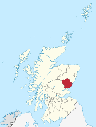
Angus is one of the 32 local government council areas of Scotland, a registration county and a lieutenancy area. The council area borders Aberdeenshire, Dundee City and Perth and Kinross. Main industries include agriculture and fishing. Global pharmaceuticals company GSK has a significant presence in Montrose in the north of the county.

Firth is a word in the English and Scots languages used to denote various coastal waters in the United Kingdom, predominantly within Scotland. In the Northern Isles, it more often refers to a smaller inlet. It is linguistically cognate to fjord, which has a more constrained sense in English. Bodies of water named "firths" tend to be more common on the Scottish east coast, or in the southwest of the country, although the Firth of Clyde is an exception to this. The Highland coast contains numerous estuaries, straits, and inlets of a similar kind, but not called "firth" ; instead, these are often called sea lochs. Before about 1850, the spelling "Frith" was more common.

<span class="mw-page-title-main">David Stevenson (engineer)</span>

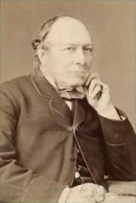
David Stevenson MICE FRSE FRSSA was a Scottish lighthouse designer, who designed over 30 lighthouses in and around Scotland, and helped continue the dynasty of lighthouse engineering founded by his father.

<span class="mw-page-title-main">Thomas Stevenson</span>

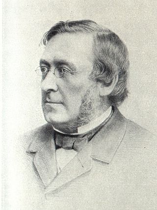
Thomas StevensonPRSE MInstCE FRSSA FSAScot was a pioneering Scottish civil engineer, lighthouse designer and meteorologist, who designed over thirty lighthouses in and around Scotland, as well as the Stevenson screen used in meteorology. His designs, celebrated as ground breaking, ushered in a new era of lighthouse creation.

The Isle of May is located in the north of the outer Firth of Forth, approximately 8 km (5.0 mi) off the coast of mainland Scotland. It is about 1.5 kilometres long and 0.5 kilometres wide. The island is owned and managed by NatureScot as a national nature reserve. There are now no permanent residents, but the island was the site of St Adrian's Priory during the Middle Ages.

<span class="mw-page-title-main">St Abb's Head</span>

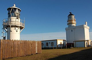
St Abb's Head is a rocky promontory by the village of St Abbs in Scottish Borders, Scotland, and a national nature reserve administered by the National Trust for Scotland. St Abb's Head Lighthouse was designed and built by the brothers David Stevenson and Thomas Stevenson and began service on 24 February 1862.

<span class="mw-page-title-main">Broulee, New South Wales</span> Town in New South Wales, Australia

Broulee is a town on the south coast of New South Wales between Batemans Bay and Moruya. At the 2016 census, the town had a population of 1,717. Just off the beach is Broulee Island, currently joined to the mainland, but in past years the connecting spit has been covered by water, at times a very deep navigable channel with a strong current.

<span class="mw-page-title-main">Tater Du Lighthouse</span> Lighthouse

Tater Du Lighthouse is Cornwall's most recently built lighthouse. The construction of the lighthouse came out of the tragedy of losing a small Spanish coaster called the Juan Ferrer on 23 October 1963, on the nearby Boscawen Point, the vessel capsized with the loss of 11 lives. After the tragedy the Newlyn and Mousehole Fishermen's Association put pressure on Trinity House for a lighthouse to be built, stating that similar tragedies could happen again. The lighthouse, built with concrete blocks, was first lit in July 1965.

<span class="mw-page-title-main">Norah Head, New South Wales</span> Place in New South Wales, Australia

Norah Head, originally known as Bungaree Noragh Point, is a headland on the Central Coast, New South Wales, Australia, south of Newcastle and north of Sydney. The nearest suburbs are Noraville, Canton Beach and Toukley. Soldiers Beach is located in Norah Head. The suburb is home to a lighthouse with scenic views, which is also considered a venue for weddings. The Norah Head tidal rock pool next to the Cabbage Tree harbour is a popular destination for families with young children due to its sheltered location.

<span class="mw-page-title-main">Chanonry Point</span> Lighthouse

Chanonry Point lies at the end of Chanonry Ness, a spit of land extending into the Moray Firth between Fortrose and Rosemarkie on the Black Isle, Scotland.

<span class="mw-page-title-main">Covesea Skerries Lighthouse</span> Lighthouse

Covesea Skerries Lighthouse, originally belonging to the Northern Lighthouse Board (NLB), is built on top of a small headland on the south coast of the Moray Firth at Covesea, near Lossiemouth, Moray, Scotland.

<span class="mw-page-title-main">Esha Ness Lighthouse</span> Lighthouse

Eshaness Lighthouse is situated on the Northmavine peninsula in the north-west of the Shetland Islands, Scotland. It sometimes rendered as Esha Ness Lighthouse.

<span class="mw-page-title-main">Fife Ness</span> Headland and most eastern point of Fife, Scotland

Fife Ness is a headland forming the most eastern point in Fife, Scotland. Anciently the area was called Muck Ross, which is a corruption of the Scottish Gaelic Muc-Rois meaning "Headland of the Pigs". It is situated in the area of Fife known as the East Neuk, and forms the muzzle of the dog-like outline of the latter when viewed on a map. Ness is an archaic Norse word meaning "nose".

<span class="mw-page-title-main">Islands of the Forth</span> Group of islands in the Firth of Forth, Scotland

The Islands of the Forth are a group of small islands located in the Firth of Forth and in the estuary of the River Forth on the east coast of Scotland. Most of the group lie in the open waters of the firth, between the Lothians and Fife, with the majority to the east of the city of Edinburgh. Two islands lie further west in the river estuary.

<span class="mw-page-title-main">Symbister</span> Human settlement in Scotland

Symbister is the largest village and port on Whalsay, an island in the Shetland archipelago of Scotland. The population in 1991 was 797. The focus of the village is the harbour, which is home to small fishing boats as well as large deep sea trawlers. The village is overlooked by the granite mansion Symbister House, built by the Sixth Robert Bruce of Symbister in 1823. The harbour is also known by the names Bay Of Symbister, Symbister Harbour and Symbister Old Harbour.

<span class="mw-page-title-main">Yell Sound</span>

Yell Sound is the strait running between Yell and Mainland, Shetland, Scotland. It is the boundary between the Mainland and the North Isles and it contains many small islands. Sullom Voe, on the shores of which is a substantial oil terminal, is an arm of Yell Sound.

<span class="mw-page-title-main">Boddam, Aberdeenshire</span> Human settlement in Scotland

Boddam is a coastal village in Aberdeenshire, Scotland. It is 29 miles (47 km) north of Aberdeen and 3 miles (4.8 km) south of Peterhead. The settlement of Stirling Village lies immediately to the west. Sea cliffs rise to 200 feet (61 m), south of the village: a coastal path leads along these to the Bullers of Buchan.

<span class="mw-page-title-main">North Carr</span>

The Carr is a sandstone reef on the headland between the Firth of Forth and St Andrews Bay. There have been many ships wrecked on the reef, which lies on the busy shipping lanes into the Forth ports and the River Tay.

<span class="mw-page-title-main">Kinnaird Head Lighthouses</span> Lighthouse

There are two lighthouses located on Kinnaird Head, in Fraserburgh, Scotland: an historical one built in a converted castle; and its modern replacement, built in 1991.

<span class="mw-page-title-main">Girdle Ness Lighthouse</span> Lighthouse in Aberdeen, Scotland

Girdle Ness Lighthouse is situated near Torry Battery on the Girdle Ness peninsula just south of the entrance to Aberdeen's harbour, in Scotland. It is an active light, managed by the Northern Lighthouse Board.

References

  1. Rowlett, Russ. "Lighthouses of Eastern Scotland". The Lighthouse Directory. University of North Carolina at Chapel Hill . Retrieved 12 May 2016.
  2. Scurdie Ness Northern Lighthouse Board. Retrieved 12 May 2016
  3. "Montrose Port Authority". Montroseport.co.uk. Retrieved 17 July 2012.
  4. "View: Montrose Harbour - Admiralty Charts of Scotland, 1795-1904". National Library of Scotland. Retrieved 17 July 2012.
  5. Smith, R.A. "Scurdie Ness to Usan Harbour" (PDF). JNCC. Retrieved 17 July 2012.
  6. Scottish Natural Heritage - SSSI
  7. "Site Details for Rickle Craig - Scurdie Ness". Scottish Natural Heritage. Retrieved 17 July 2012.
  8. "Built heritage and archaeology" (PDF). The SCAPE Trust. Retrieved 17 July 2012.
  9. Good Stuff IT Services (11 June 1971). "Scurdie Ness Lighthouse (montroseness Lighthouse), Craig". British Listed Buildings. Retrieved 17 July 2012.
  10. 1 2 "Scurdie Ness". Northern Lighthouse Board. Retrieved 17 July 2012.
  11. Radar577. "Humpback Whale in Montrose Bay". YouTube. Archived from the original on 20 December 2021. Retrieved 17 July 2012.
  12. "Recording data on Montrose Bay's whales and dolphins". The Courier. 23 July 2011. Retrieved 17 July 2012.
  13. "Tayside Biodiversity Partnership Local Action Plan". Tayside Biodiversity. Archived from the original on 25 April 2012. Retrieved 17 July 2012.
  14. "Scottish Agates - Montrose". Agatesofscotland.co.uk. Archived from the original on 25 April 2012. Retrieved 17 July 2012.