
The Bay of Fundy is a bay between the Canadian provinces of New Brunswick and Nova Scotia, with a small portion touching the U.S. state of Maine. It is an arm of the Gulf of Maine. Its tidal range is the highest in the world. The name is probably a corruption of the French word fendu, meaning 'split'.
The Wildfowl & Wetlands Trust (WWT) is an international wildfowl and wetland conservation charity in the United Kingdom.

WWT Arundel is one of ten wildfowl and wetland nature reserves managed by the Wildfowl and Wetlands Trust, a nature conservation charity in the United Kingdom. The 60 acres (24 ha) reserve is situated at the foot of the Offham Hangar, a part of the Arun valley in Arundel, West Sussex, England.

RSPB Leighton Moss is a nature reserve in Lancashire, England, which has been in the care of the Royal Society for the Protection of Birds since 1964. It is situated near Silverdale, Carnforth, on the edge of Morecambe Bay and in the Arnside and Silverdale Area of Outstanding Natural Beauty.

Titchwell Marsh is an English nature reserve owned and managed by the Royal Society for the Protection of Birds (RSPB). Located on the north coast of the county of Norfolk, between the villages of Titchwell and Thornham, about 8 km (5.0 mi) east of the seaside resort of Hunstanton, its 171 hectares include reed beds, saltmarshes, a freshwater lagoon and sandy beach, with a small woodland area near the car park. This internationally important reserve is part of the North Norfolk Coast Site of Special Scientific Interest (SSSI) and the Norfolk Coast Area of Outstanding Natural Beauty (AONB), and is also protected through Natura 2000, Special Protection Area (SPA) and Ramsar listings.
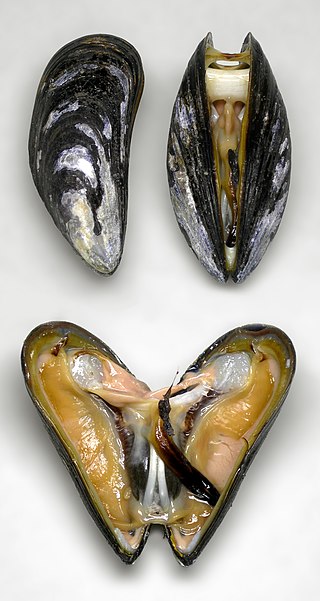
The blue mussel, also known as the common mussel, is a medium-sized edible marine bivalve mollusc in the family Mytilidae, the only extant family in the order Mytilida, known as "true mussels". Blue mussels are subject to commercial use and intensive aquaculture. A species with a large range, empty shells are commonly found on beaches around the world.

Loch Fleet is a sea loch on the east coast of Scotland, located between Golspie and Dornoch. It forms the estuary of the River Fleet, a small spate river that rises in the hills east of Lairg. The loch was designated a National Nature Reserve (NNR) in 1998, and is managed by a partnership between NatureScot, the Scottish Wildlife Trust (SWT) and Sutherland Estates. The NNR extends to 1058 hectares, including the Loch Fleet tidal basin, sand dunes, shingle ridges and the adjacent pine woods, including Balbair Wood and Ferry Wood. The tidal basin of the loch covers over 630 ha, and forms the largest habitat on the NNR.
Foulney Island is a low-lying grass and shingle area 1 mile (1.6 km) to the south-east of Roa Island, off the southern tip of the Furness Peninsula in Cumbria, England. Foulney Island is one of the Islands of Furness in Morecambe Bay, northern England. For local government purposes the island is in the borough of Barrow-in-Furness. It has an area of about 40 acres. In earlier times it was known as Fowle Island.
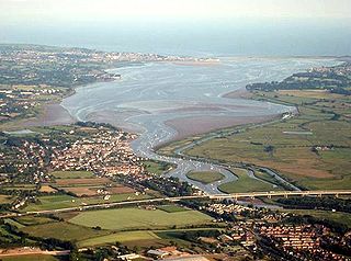
The Exe estuary is an estuary on the south coast of Devon, England.

The Scottish Wildlife Trust is a registered charity dedicated to conserving the wildlife and natural environment of Scotland.

The estuaries of the River Ribble and River Alt lie on the Irish Sea coasts of Lancashire and Merseyside in North West England. Together they, and the area of salt marsh, mudflats, and sand dunes between them, form a Special Protection Area and Ramsar site which covers the coastline between Crosby and Lytham St Annes. These protected areas overlap with two sites of special scientific interest, Ribble Estuary and Sefton Coast.

The Ythan Estuary is the tidal component of the Ythan River, emptying into the North Sea 19 kilometres (12 mi) north of Aberdeen, Scotland. The estuary’s tidal action extends a 7 kilometres (4.3 mi) inland and has characteristic widths of between 250 metres (820 ft) and 780 metres (2,560 ft). Besides the tidal channel there are interfaces to the upland dunes including mudflats, sand beaches and shingle flats. Reaches of salt marsh occur, but they are primarily near the Waterside Bridge and the mouth of the Tarty Burn, a small tributary river. Based upon the habitat of the moorland bordering the east of the Ythan River near the mouth, this estuary is the most significant coastal moorland in the northern United Kingdom.
The Alaksen National Wildlife Area is located on Westham Island in the city of Delta, British Columbia. It is an important stopover point for many species of birds migrating along the Pacific Flyway.

Oare Marshes is a 71.4-hectare (176-acre) Local Nature Reserve north of Faversham in Kent. It is owned and managed by Kent Wildlife Trust. It is part of The Swale Nature Conservation Review site, Grade I, National Nature Reserve, Ramsar internationally important wetland site, Special Protection Area under the European Union Directive on the Conservation of Wild Birds, and Site of Special Scientific Interest.
Grazing marsh is a British Isles term for flat, marshy grassland in polders. It consists of large grass fields separated by fresh or brackish ditches, and is often important for its wildlife.
Alde Mudflats is a 22 hectare nature reserve west of Iken in Suffolk. It is owned by the Crown Estate and managed by the Suffolk Wildlife Trust. It is in the Suffolk Coast and Heaths Area of Outstanding Natural Beauty, and part of the Alde-Ore Estuary Site of Special Scientific Interest, Ramsar internationally important wetland site, Special Area of Conservation, Special Protection Area under the European Union Directive on the Conservation of Wild Birds, and Grade I Nature Conservation Review site,

Cley Marshes is a 176-hectare (430-acre) nature reserve on the North Sea coast of England just outside the village of Cley next the Sea, Norfolk. A reserve since 1926, it is the oldest of the reserves belonging to the Norfolk Wildlife Trust (NWT), which is itself the oldest county Wildlife Trust in the United Kingdom. Cley Marshes protects an area of reed beds, freshwater marsh, pools and wet meadows and is part of the North Norfolk Coast Site of Special Scientific Interest (SSSI), Special Area of Conservation (SAC), Special Protection Area (SPA), and Ramsar Site due to the large numbers of birds it attracts.

Blackwater, Crouch, Roach and Colne Estuaries is a Marine Conservation Zone (MCZ), located in Essex, England. It includes the Blackwater, Colne, Crouch and Roach estuaries as well as the coast between them. It extends from the mean high water mark to where the estuary mouths join the North Sea. With a total area of 284 square kilometres (110 sq mi), it the largest inshore MCZ in England.
The Inner Clyde Estuary is a nature reserve and protected wetland area in the estuary of the River Clyde, on the west coast of central Scotland. An area of 1,826 hectares has been designated since 2000 as a Ramsar Site, a Special Protection Area and a Site of Special Scientific Interest.
Milford Haven Waterway, is a Site of Special Scientific Interest (SSSI) on Milford Haven Waterway in Pembrokeshire, South Wales, designated since 2002. The site is protected for a wide range of reasons, including its geology, marine environment and ecosystems, and to protect a diversity of flora and fauna.


