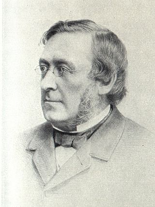
David Stevenson MICE FRSE FRSSA was a Scottish lighthouse designer, who designed over 30 lighthouses in and around Scotland, and helped continue the dynasty of lighthouse engineering founded by his father.

The Pentland Firth is a strait which separates the Orkney Islands from Caithness in the north of Scotland. Despite the name, it is not a firth.
Auskerry is a small island in eastern Orkney, Scotland. It lies in the North Sea south of Stronsay and has a lighthouse, completed in 1866.
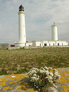
The Pentland Skerries are a group of four uninhabited islands lying in the Pentland Firth, northeast of Duncansby Head and south of South Ronaldsay in Scotland.

Dunnet Head is a peninsula in Caithness, on the north coast of Scotland. Dunnet Head includes the most northerly point of both mainland Scotland and the island of Great Britain.

Bound Skerry is part of the Out Skerries group in the Shetland Islands. As well as being the most easterly island of that group, it is also the easternmost point of Scotland.

Muckle Flugga lighthouse punctuates the rocky stack of Muckle Flugga, in Shetland, Scotland. Originally called North Unst Lighthouse, it was renamed in 1964.

Thomas Smith was a Scottish businessman and early lighthouse engineer. He was appointed as the first Chief Engineer to the Northern Lighthouse Board in 1786.

Fidra is a currently uninhabited island in the Firth of Forth, 4 kilometres northwest of North Berwick, on the east coast of Scotland. The island is an RSPB Scotland nature reserve.

Sule Skerry is a remote skerry in the North Atlantic off the north coast of Scotland.

Duncansby Head is the most northeasterly part of both the Scottish and British mainlands, slightly northeast of John o' Groats. It lies approximately 20 km (12 mi) east-southeast of Dunnet Head, the northernmost point of both the Scottish and British mainlands. Duncansby Head is located in Caithness, Highland, in north-eastern Scotland. The headland juts into the North Sea, with the Pentland Firth to its north and west and the Moray Firth to its south.

The Tarbat Ness Lighthouse is located at the North West tip of the Tarbat Ness peninsula near the fishing village of Portmahomack on the east coast of Scotland. It was built in 1830 by Robert Stevenson and has an elevation of 53 metres (174 ft) and 203 steps to the top of the tower.

Covesea Skerries Lighthouse, originally belonging to the Northern Lighthouse Board (NLB), is built on top of a small headland on the south coast of the Moray Firth at Covesea, near Lossiemouth, Moray, Scotland.

The Islands of the Forth are a group of small islands located in the Firth of Forth and in the estuary of the River Forth on the east coast of Scotland. Most of the group lie in the open waters of the firth, between the Lothians and Fife, with the majority to the east of the city of Edinburgh. Two islands lie further west in the river estuary.

Yell Sound is the strait running between Yell and Mainland, Shetland, Scotland. It is the boundary between the Mainland and the North Isles and it contains many small islands. Sullom Voe, on the shores of which is a substantial oil terminal, is an arm of Yell Sound.

Eilean Musdile (Mansedale) is an islet, and lighthouse to the south west of Lismore in the Inner Hebrides.
Events from the year 1884 in Scotland.
Events from the year 1794 in Scotland.