Bound Skerry

Last updated

An aerial view of Grunay with Bound Skerry in background Grunay.jpg
An aerial view of Grunay with Bound Skerry in background
Bound Skerry
Location
Shetland UK relief location map.jpg
Red pog.svg
Bound Skerry
Bound Skerry shown within Scotland
OS grid reference HU702719
Coordinates 60°25′26″N0°43′41″W / 60.424°N 0.728°W / 60.424; -0.728 Coordinates: 60°25′26″N0°43′41″W / 60.424°N 0.728°W / 60.424; -0.728
Physical geography
Island group Out Skerries Shetland
Area0.05 km
Administration
Sovereign state United Kingdom
Country Scotland
Council area Shetland Islands
Demographics
Population0
Lymphad3.svg
References [1] [2]
Bound Skerry Lighthouse OOjs UI icon edit-ltr-progressive.svg
Bound Skerry Lighthouse - geograph.org.uk - 1409555.jpg
Bound Skerry Lighthouse in 2009
Constructed1858  OOjs UI icon edit-ltr-progressive.svg
Built by David Stevenson, Thomas Stevenson   OOjs UI icon edit-ltr-progressive.svg
Constructionstone  OOjs UI icon edit-ltr-progressive.svg
Automated7 April 1972  OOjs UI icon edit-ltr-progressive.svg
Height30 m (98 ft)  OOjs UI icon edit-ltr-progressive.svg
Shapecylindrical tower with balcony and lantern
Markingswhite (tower), black (lantern), ochre (trim)  OOjs UI icon edit-ltr-progressive.svg
Operator Northern Lighthouse Board   OOjs UI icon edit-ltr-progressive.svg
Heritagecategory B listed building  OOjs UI icon edit-ltr-progressive.svg
Focal height44 m (144 ft)  OOjs UI icon edit-ltr-progressive.svg
Intensity159,000 candela  OOjs UI icon edit-ltr-progressive.svg
Range20 nmi (37 km; 23 mi)  OOjs UI icon edit-ltr-progressive.svg
Characteristic Fl W 20s  OOjs UI icon edit-ltr-progressive.svg

Bound Skerry is part of the Out Skerries group in the Shetland Islands. As well as being the most easterly island of that group, it is also the easternmost point of Scotland.

Contents

It has a lighthouse on it, which was built in 1857 at a cost of £21,000. [3] [4] Robert Louis Stevenson's family were lighthouse builders, and his signature can be seen in its guestbook. [1] The keepers lived on nearby Grunay.

The island was bombed twice in World War II by the German Luftwaffe, because it was suspected to harbour a munitions factory. [1]

See also

Related Research Articles

<span class="mw-page-title-main">Bressay Lighthouse</span> Lighthouse in Shetland, Scotland

Bressay Lighthouse is still an active lighthouse in the Shetland Islands, Scotland, 4 kilometres (2.5 mi) south-east of Lerwick. It is located on the island of Bressay at Kirkabister Ness overlooking Bressay Sound.

The Out Skerries are an archipelago of islets, some inhabited, in Shetland, Scotland, and are the easternmost part of Shetland. Locally, they are usually called Da Skerries or just Skerries.

<span class="mw-page-title-main">Muckle Roe</span>

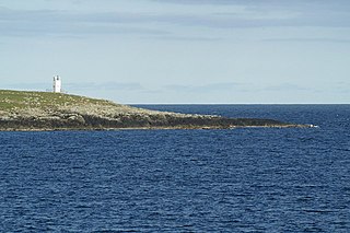
Muckle Roe is an island in Shetland, Scotland, in St. Magnus Bay, to the west of Mainland. It has a population of around 130 people, who mainly croft and live in the south east of the island.

<span class="mw-page-title-main">Balta, Shetland</span>

Balta is an uninhabited island in Shetland, Scotland.

<span class="mw-page-title-main">Muckle Flugga Lighthouse</span> Lighthouse

Muckle Flugga lighthouse punctuates the rocky stack of Muckle Flugga, in Shetland, Scotland. Originally called North Unst Lighthouse, it was renamed in 1964.

<span class="mw-page-title-main">Sule Skerry</span> Remote skerry in the North Atlantic off the north coast of Scotland

Sule Skerry is a remote skerry in the North Atlantic off the north coast of Scotland.

<span class="mw-page-title-main">Muckle Skerry</span> Island off the Scottish coast

Muckle Skerry is the largest of the Pentland Skerries that lie off the north coast of Scotland. It is home to the Pentland Skerries Lighthouse.

<span class="mw-page-title-main">Grunay</span> Lighthouse

Grunay is an uninhabited island in the Out Skerries group, the most easterly part of Shetland, Scotland. Its area is 55.58 acres, or 22.49 hectares.

<span class="mw-page-title-main">Covesea Skerries Lighthouse</span> Lighthouse

Covesea Skerries Lighthouse, originally belonging to the Northern Lighthouse Board (NLB), is built on top of a small headland on the south coast of the Moray Firth at Covesea, near Lossiemouth, Moray, Scotland.

<span class="mw-page-title-main">Esha Ness Lighthouse</span> Lighthouse

Eshaness Lighthouse is situated on the Northmavine peninsula in the north-west of the Shetland Islands, Scotland. It sometimes rendered as Esha Ness Lighthouse.

<span class="mw-page-title-main">Ve Skerries</span> Small islands in the west of Shetland

The Ve Skerries or Vee Skerries are a group of low skerries three miles (4.8 km) north west of Papa Stour, on the west coast of Shetland, Scotland. They define the southwest perimeter of St Magnus Bay.

<span class="mw-page-title-main">Peerie Bard</span> Lighthouse

Perie Bard is one of the Shetland Islands. It is a small islet off the east coast of the island of Mousa.

<span class="mw-page-title-main">Yell Sound</span>

Yell Sound is the strait running between Yell and Mainland, Shetland, Scotland. It is the boundary between the Mainland and the North Isles and it contains many small islands. Sullom Voe, on the shores of which is a substantial oil terminal, is an arm of Yell Sound.

<span class="mw-page-title-main">Barrel of Butter</span> Skerry in Scapa Flow in the Orkney Islands

The Barrel of Butter, formerly known as Carlin Skerry, is a skerry in Scapa Flow in the Orkney Islands.

<span class="mw-page-title-main">Haskeir</span>

Haskeir, also known as Great Haskeir is a remote, exposed and uninhabited island in the Outer Hebrides of Scotland. It lies 13 kilometres west-northwest of North Uist. 1 km southwest lie the skerries of Haskeir Eagach, made up of a colonnade of five rock stacks, and 40 km (25 mi) northwest is St Kilda.

<span class="mw-page-title-main">Hoo Stack</span> Lighthouse

Hoo Stack is a small island off Nesting in Shetland. It is one and a half miles from the North Isle of Gletness. It is 34 metres (112 ft) at its highest point, and is home to a lighthouse, which was built in 1986.

<span class="mw-page-title-main">Eilean Musdile</span> Lighthouse

Eilean Musdile (Mansedale) is an islet, and lighthouse to the south west of Lismore in the Inner Hebrides.

<span class="mw-page-title-main">Cairns of Coll</span> Lighthouse

The Cairns of Coll refers primarily to a region of rocky outcrops in shallow waters extending from the north end of the Island of Coll in the Inner Hebrides of Scotland. The extension is about 1.1 miles from shore, 1.6 if the Cairns of Coll Rocks 0.5 miles further are to be included. The outcrops of the Cairns are too small to be inhabited. The swift and unpredictable tidal currents between them make navigation hazardous to boats. They are rich in abundant and varied marine life, including the marine mammals.

References

  1. 1 2 3 Haswell-Smith, Hamish (2004). The Scottish Islands. Edinburgh: Canongate. ISBN   978-1-84195-454-7.
  2. Ordnance Survey. OS Maps Online (Map). 1:25,000. Leisure.
  3. Rowlett, Russ. "Lighthouses of Scotland: Shetland". The Lighthouse Directory. University of North Carolina at Chapel Hill . Retrieved 29 May 2016.
  4. Out Skerries Northern Lighthouse Board. Retrieved 29 May 2016