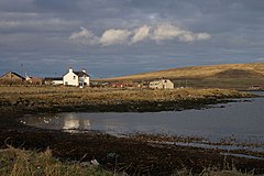
Shetland, also called the Shetland Islands and formerly Zetland, is an archipelago in Scotland lying between Orkney, the Faroe Islands, and Norway. It is the northernmost region of the United Kingdom.
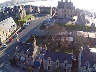
Lerwick is the main town and port of the Shetland archipelago, Scotland. Shetland's only burgh, Lerwick had a population of about 7,000 residents in 2010.

Fetlar is one of the North Isles of Shetland, Scotland, with a usually resident population of 61 at the time of the 2011 census. Its main settlement is Houbie on the south coast, home to the Fetlar Interpretive Centre. Other settlements include Aith, Funzie, Herra and Tresta. Fetlar is the fourth-largest island of Shetland and has an area of just over 4,000 ha.
Unst is one of the North Isles of the Shetland Islands, Scotland. It is the northernmost of the inhabited British Isles and is the third-largest island in Shetland after Mainland and Yell. It has an area of 46 sq mi (120 km2).
Papa Stour is one of the Shetland Islands in Scotland, with a population of under fifteen people, some of whom immigrated after an appeal for residents in the 1970s. Located to the west of mainland Shetland and with an area of 828 hectares, Papa Stour is the eighth largest island in Shetland. Erosion of the soft volcanic rocks by the sea has created an extraordinary variety of caves, stacks, arches, blowholes, and cliffs. The island and its surrounding seas harbour diverse populations of wildlife. The west side of the island is a Site of Special Scientific Interest and the seas around the island are a Special Area of Conservation.
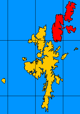
The North Isles are the northern islands of the Shetland Islands, Scotland. The main islands in the group are Yell, Unst and Fetlar. Sometimes the islands in Yell Sound are included in this group.
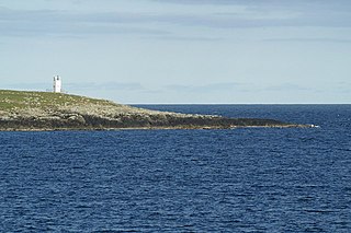
Balta is an uninhabited island in Shetland, Scotland.

Dunnet Head is a peninsula in Caithness, on the north coast of Scotland. Dunnet Head includes the most northerly point of both mainland Scotland and the island of Great Britain.

Muckle Flugga lighthouse punctuates the rocky stack of Muckle Flugga, in Shetland, Scotland. Originally called North Unst Lighthouse, it was renamed in 1964.
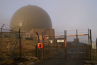
Remote Radar Head Saxa Vord or RRH Saxa Vord, is a Royal Air Force radar station located on the island of Unst, the most northern of the Shetland Islands in Scotland. As of July 2019 it is once more a fully operational radar station, after closure in 2006. The station's motto Praemoneo de Periculis reflects its role. RAF Saxa Vord is further north than Saint Petersburg in Russia, and on the same latitude as Anchorage, Alaska. The station was named after Saxa Vord, which is the highest hill on Unst at 935 ft (285 m). It holds the unofficial British record for wind speed, which in 1992 was recorded at 197 mph (317 km/h) — just before the measuring equipment blew away.

Skaw is a settlement in the Scottish archipelago of Shetland, located on the island of Unst. It is located north of Haroldswick on a peninsula in the northeast corner of the island, and is the most northerly settlement in the United Kingdom. It is currently inhabited by a single inhabitant whose business is sheep farming.

Baltasound is the largest settlement on the island of Unst in Shetland, Scotland. It comes from the Old Norse man's name Balti (Baltisund). Unst is the most northerly inhabited island in the United Kingdom. The village lies halfway along the island's east coast on a sheltered bay called Balta Sound.

Yell Sound is the strait running between Yell and Mainland, Shetland, Scotland. It is the boundary between the Mainland and the North Isles and it contains many small islands. Sullom Voe, on the shores of which is a substantial oil terminal, is an arm of Yell Sound.
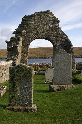
Sandsting is a parish in the West Mainland of Shetland, Scotland, forming a southern arm of the Walls Peninsula. After the parish of Aithsting was annexed into Sandsting in the sixteenth century, it became known as Sandsting and Aithsting parish.

Ollaberry is a village on Mainland, Shetland, Scotland on the west shore of Yell Sound, 10.9 miles (17.5 km) north by road from Brae. Ollaberry Churchyard contains a Listed B monument, sculpted by John Forbes in 1754. Ollaberry Primary School was established in 1873.

Sandwick is a village and an ancient parish in the Shetland Islands, Scotland. It was merged in 1891, along with Cunningsburgh, into Dunrossness. Sandwick is located 13 miles (21 km) south of Lerwick in the South Mainland, and is considered a Tier 1 settlement in Shetland. It comprises a number of distinct settlements in very close proximity to each other, each remaining distinct through being separated by agricultural land. These settlements within Sandwick include Old Sandwick, Leebitton, Broonies' Taing, Stove, Swinister and Hoswick; the latter is almost a village in its own right and is often considered distinct from Sandwick.

Gossabrough is a coastal hamlet, wick and ness on the southeast side of the island of Yell, Shetland, Scotland. The Wick of Gossabrough lies between the northern extremity of Gossabrough Ness and the Saddle of Swarister. The hamlet is accessed via the B9081 road. The Loch of Hudon lies just to the southwest.
Olwyn Owen, FSA Scot, is a British archaeologist and academic specialising in Scandianvian Scotland.
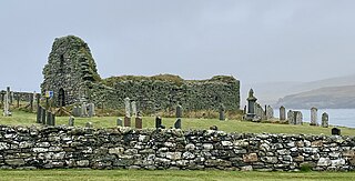
St Olaf's Church, Unst is a ruined medieval church located on the island of Unst, in Shetland, Scotland, UK. The church was built in the Celtic style, and dates to the twelfth century. The burial ground surrounding the church includes several early medieval stone crosses. Historic Environment Scotland first listed the site as a scheduled monument in 1957.
