Shetland, also called the Shetland Islands, is an archipelago in Scotland lying between Orkney, the Faroe Islands, and Norway. It is the northernmost region of the United Kingdom.

Foula, located in the Shetland archipelago of Scotland, is one of the United Kingdom's most remote permanently inhabited islands. Owned since the turn of the 20th century by the Holbourn family, the island was the location for the film The Edge of the World (1937). The liner RMS Oceanic was wrecked on the nearby Shaalds of Foula in 1914. The island has a post office.
Yell is one of the North Isles of Shetland, Scotland. In the 2011 census it had a usually resident population of 966. It is the second largest island in Shetland after the Mainland with an area of 82 square miles (212 km2), and is the third most populous in the archipelago, after the Mainland and Whalsay.

West Burra is one of the Scalloway Islands, a subgroup of the Shetland Islands in Scotland. It is connected by bridge to East Burra. With an area of 743 hectares, it is the eleventh-largest of the Shetland Islands.

East Burra is one of the Scalloway Islands, a subgroup of the Shetland Islands in Scotland. It is connected by a bridge to West Burra.

The Northern Isles are a chain of islands off the north coast of mainland Scotland. The climate is cool and temperate and highly influenced by the surrounding seas. There are two main island groups: Shetland and Orkney. There are a total of 36 inhabited islands, with the fertile agricultural islands of Orkney contrasting with the more rugged Shetland islands to the north, where the economy is more dependent on fishing and the oil wealth of the surrounding seas. Both archipelagos have a developing renewable energy industry. They share a common Pictish and Norse history, and were part of the Kingdom of Norway before being absorbed into the Kingdom of Scotland in the 15th century. The islands played a significant naval role during the world wars of the 20th century.

Muckle Roe is an island in Shetland, Scotland, in St. Magnus Bay, to the west of Mainland. It has a population of around 130 people, who mainly croft and live in the south east of the island.

Vementry is an uninhabited Scottish island in Shetland on the north side of the West Mainland, lying south of Muckle Roe.
Uyea is an uninhabited island, lying south of Unst in Shetland, Scotland.
Trondra is one of the Scalloway Islands, a subgroup of the Shetland Islands in Scotland. It shelters the harbour of Scalloway and has an area of 275 hectares (1.06 sq mi).
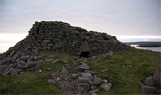
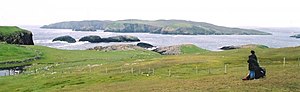
The Broch of Culswick is an unexcavated coastal broch in the Shetland Islands of Scotland. It has good views all around, including Foula and Vaila isles, and Fitful Head and Fair Isle in the south. The broch stands on the top of a rock platform and is about 3 metres high at its tallest point. Much rubble has fallen into the centre. This broch has a massive triangular lintel stone over the entrance, which is partly filled with rubble. Drawings by Low in 1774 and Skene in 1805 reveal that the structure survived very well up to those dates.
Tanera Mòr is a sporadically inhabited island in Loch Broom in the Inner Hebrides of Scotland, the largest of the Summer Isles. It was the last permanently inhabited island in that group. Tanera Mòr has issued its own postage stamps and was the location of Frank Fraser Darling's book Island Years. In 2014, it was reported that it had been sold to the millionaire Ian Wace, whose plans were to develop it as a holiday destination.
West Linga is an uninhabited island located between Mainland and Whalsay in Shetland, Scotland.

Linga is one of the Shetland Islands, near Vaila and Walls on Mainland, Shetland. Its highest elevation is 28 metres (91 ft). In 2014 and 2018 it was reported that the island was for sale for £250,000.
Burrastow is a location on the west shore of Vaila Sound near the village of Walls on the Shetland Mainland, Scotland. There are two small piers and the imposing 18th-century Burrastow House. To the east is the bay of Lera Voe and the two small islets of Holm of Breibister and Holm of Burrastow. To the south is Wester Sound, which lies between the mainland and Vaila. The rocky coast contains numerous caves, geos and skerries. Otters and seals are commonly seen offshore.

St Magnus Bay is a large coastal feature in the north-west of Mainland Shetland, Scotland. Roughly circular in shape with a diameter of about 19 kilometres (12 mi), it is open to the North Atlantic Ocean to the west. The indented coastline to the north, south and east between Esha Ness in the north and the Ness of Melby in the south contains numerous bays, firths and voes and there are several islands around the perimeter. The waters of the bay are up to 165 metres (541 ft) deep and may have been the site of a substantial meteor impact.