
Sullom Voe is an inlet of the North Sea between the parishes of Delting and Northmavine in Shetland, Scotland. It is a location of the Sullom Voe oil terminal and Shetland Gas Plant. The word Voe is from the Old Norse vagr and denotes a small bay or narrow creek. The head of the voe makes up the eastern side of Mavis Grind.
The Mainland is the main island of Shetland, Scotland. The island contains Shetland's only burgh, Lerwick, and is the centre of Shetland's ferry and air connections.

Gruney is a small, uninhabited island in Shetland, Scotland. It lies north of the Northmavine peninsula of the Shetland Mainland, from which it is separated by the Gruney Sound.

Mavis Grind is a narrow isthmus joining the Northmavine peninsula to the rest of the island of Mainland in the Shetland Islands, Scotland. It is just over 90 metres at its narrowest point.

The North Mainland of the Shetland Islands, Scotland is the part of the Mainland lying north of Voe.

Eshaness Lighthouse is situated on the Northmavine peninsula in the north-west of the Shetland Islands, Scotland. It sometimes rendered as Esha Ness Lighthouse.

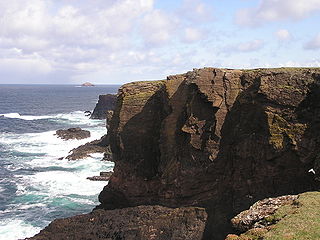
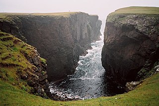
Esha Ness, also spelled Eshaness, is a peninsula on the west coast of Northmavine, on the island of Mainland, Shetland, Scotland. Esha Ness Lighthouse is located on the west coast of the peninsula, just south of Calder's Geo. The lighthouse was designed by David Alan Stevenson and commissioned in 1929. The hamlet of Tangwick contains the Tangwick Haa, a former Laird's house that has been a museum since 1987.

Uyea is an uninhabited tidal island located to the northwest of Mainland, Shetland. Uyea lies off the Northmavine peninsula, from where it can be reached by foot at low tide. The island's highest elevation is 70 metres (230 ft) and its area is 45 hectares (0.17 sq mi).
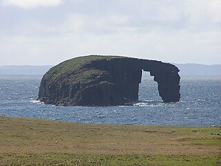
The Dore Holm is a small uninhabited islet off the south coast of Esha Ness, located in the north-west of Mainland, Shetland, Scotland. Its natural arch can be seen from the coast between Tangwick and Stenness. The shape of the arch has been compared to a horse drinking deeply from the water.

The Isle of Stenness is one of the Shetland Islands, Scotland. It is off north west Mainland in the Northmavine.

Nesting is a parish in the Shetland Islands, Scotland. It includes a part of the east Shetland Mainland, measuring about twelve by four miles, along the seaboard from Gletness to Lunna Ness, and also the island of Whalsay and the Out Skerries. The coast is deeply indented by voes and headlands. The arable land comprises only about 1,000 acres, the remainder being mostly open moorland. The total area is given as 105.6 km2. This includes the ancient parish of Lunnasting in the North and the island parish of Whalsay to the east, which were added to Nesting in 1891. Before that, the ancient parishes of North Nesting and South Nesting were merged.
Sandsting is a parish in the West Mainland of Shetland, Scotland, forming a southern arm of the Walls Peninsula. After the parish of Aithsting was annexed into Sandsting in the sixteenth century, it became known as Sandsting and Aithsting parish.
Geopark Shetland is the name used by the Geopark formally established in September 2009 on its entry into the European Geoparks Network. The Geopark extends across the entire Shetland archipelago off the north coast of mainland Scotland. It is administered by the Shetland Amenity Trust in partnership with organisations such as Scottish Natural Heritage, the Shetland Islands Council, Highlands and Islands Enterprise and various community and tourism associations.

St Magnus Bay is a large coastal feature in the north-west of Mainland Shetland, Scotland. Roughly circular in shape with a diameter of about 19 kilometres (12 mi), it is open to the North Atlantic Ocean to the west. The indented coastline to the north, south and east between Esha Ness in the north and the Ness of Melby in the south contains numerous bays, firths and voes and there are several islands around the perimeter. The waters of the bay are up to 165 metres (541 ft) deep and may have been the site of a substantial meteor impact.
Calders Geo is an inlet in the western cliffs of Esha Ness in Northmavine on the Mainland, Shetland, Scotland. A cave on the north side of the geo has been measured at more than one and a half times the size of "The Frozen Deep", a chamber in Reservoir Hole under Cheddar Gorge in Somerset, potentially making it the largest natural chamber in Britain.

The Drongs are a group of sea stacks off the coast of Hillswick Ness, Northmavine, Shetland, Scotland. They lie to the west of the Isle of Westerhouse in St Magnus Bay. They have been described as "a focus of interest from all surrounding parts, including Eshaness", from which they are the most readily viewed, and as such are considered an icon of Eshaness, along with the famous Dore Holm.
Sir John Cheyne of Tangwick KC LLD (1841–1907) was a 19th/20th century Scottish judge.
John Williamson, more commonly known by the nickname Johnnie Notions was a self-taught physician from Shetland, Scotland, who independently developed and administered an inoculation for smallpox to thousands of patients in Shetland during the late 18th century. Despite having only an elementary education and no formal medical background, the treatment he devised had an extremely high success rate, resulting in the immunisation of approximately 3,000 people and the saving of many lives, which had a significant effect on the demographics of the Shetland population at the time. He is reputed not to have lost a single patient.

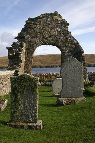
Tangwick Haa is an historic house and museum in Esha Ness, Northmavine, Shetland. The building has two stories in a rectangular layout and along with the adjacent walled garden is Category B listed.


