
Shetland, also called the Shetland Islands, is an archipelago in Scotland lying between Orkney, the Faroe Islands, and Norway. It is the northernmost region of the United Kingdom. Until 1975, it was known as Zetland.
Papa Stour is one of the Shetland Islands in Scotland, with a population of under fifteen people, some of whom immigrated after an appeal for residents in the 1970s. Located to the west of mainland Shetland and with an area of 828 hectares, Papa Stour is the ninth largest island in Shetland. Erosion of the soft volcanic rocks by the sea has created an extraordinary variety of caves, stacks, arches, blowholes, and cliffs. The island and its surrounding seas harbour diverse populations of wildlife. The west side of the island is a Site of Special Scientific Interest and the seas around the island are a Special Area of Conservation.

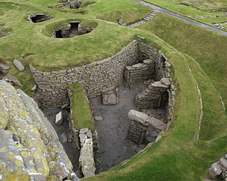
Jarlshof is the best-known prehistoric archaeological site in Shetland, Scotland. It lies in Sumburgh, Mainland, Shetland and has been described as "one of the most remarkable archaeological sites ever excavated in the British Isles". It contains remains dating from 2500 BC up to the 17th century AD.
MV Braer was an oil tanker which ran aground during a storm off Shetland, Scotland, in January 1993, and nearly a week later broke up during the most intense extratropical cyclone on record for the northern Atlantic Ocean, the Braer Storm of January 1993.

Old Scatness is an archeological site on Scat Ness, near the village of Scatness, in the parish of Dunrossness in the south end of Mainland, Shetland, Scotland, near Sumburgh Airport. It consists of medieval, Viking, Pictish, and Iron Age remains and has been a settlement for thousands of years, each new generation adding buildings, and levelling off old ones. Among the discoveries is an Iron Age broch, the Ness of Burgi fort.

The Shetland Amenity Trust is a charitable trust based in Shetland, Scotland. It was formed in 1983.

Colsay is an uninhabited island off the South West coast of Mainland, Shetland. Fora Ness lies to the south, across the Muckle Sound. The highest elevation is 44 metres (144 ft), and there is an ancient cairn on the summit.
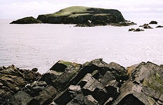
Horse Island or Horse Holm, known locally as Da Holm, is one of the Shetland Islands. It lies about 2.3 km west of Sumburgh Head at the south tip of the Mainland, Shetland. In the Norn language, it was called Hundiholmi but was later renamed Horse Holm. It is used as an alignment point by local fishermen for several fishing marks.

Dunrossness, is the southernmost parish of Shetland, Scotland. Historically the name Dunrossness has usually referred to the area on the Shetland mainland south of Quarff. However, in 2016 there were three separate Shetland Community Councils for a) Gulberwick, Quarff and Cunningsburgh; b) Sandwick; and c) Dunrossness. The 2011 census defined Dunrossness as including everybody within the British ZE2 postal code, which goes as far north as Gulberwick. It has the best and largest area of fertile farmland of any parish in Shetland. Dunrossness includes the island of Mousa, Levenwick, St Ninian's Isle, Bigton, Scousburgh, the Lochs of Spiggie and Brow, Boddam, Quendale, Virkie, Exnaboe, Grutness, Toab, Ness of Burgi, Clumlie Broch, Scatness, Sumburgh Airport, Sumburgh Head, West Voe, the islands of Lady's Holm, Little Holm, Horse Holm island and Fair Isle.

Virkie is the most southerly district of Shetland, other than Fair Isle and is best defined as the area south of the Ward Hill in Dunrossness, also locally referred to as "below da hill", or "da laich Ness".

Scatness is a settlement on the headland of Scat Ness at the southern tip of Mainland, Shetland, Scotland, across the West Voe of Sumburgh from Sumburgh Head and close to Sumburgh Airport, the Shetland Islands' main airport. Scatness is in the parish of Dunrossness.
Sabine Glacier is a glacier terminating at the sea between Wennersgaard Point and Cape Kater on the northwest coast of Graham Land, Antarctica.
Lady's Holm is an island off southern Mainland in the Shetland Islands. It is not to be confused with the Maiden Stack, which is also known as "Frau Stack"

Little Holm is a small island to the west of South Mainland in Shetland. It is near Scatness and Lady's Holm. A trawler was wrecked there in 1916.

The Ness of Burgi is a narrow peninsula that stretches to the south from the Scat Ness headland of Mainland, Shetland, a Scottish island. It is in the parish of Dunrossness.

The Zenith of Iron Age Shetland is a combination of three sites in Shetland that have applied to be on the Scottish "Tentative List" of possible nominations for the UNESCO World Heritage Programme list of sites of outstanding cultural or natural importance to the common heritage of humankind. The application was made by the Shetland Amenity Trust in 2010, and in 2011 the site became one of 11 successful UK applications to join the Tentative List, three of them from Scotland.
Prehistoric Shetland refers to the prehistoric period of the Shetland archipelago of Scotland, when it was first occupied by humans. The period prior to human settlement in Shetland is known as the geology of Scotland. Prehistory in Shetland does not end until the beginning of the Early Medieval Period in Scotland, around AD 600. More than 5,000 archaeological sites have been recorded in the Shetland Islands.

On 23 August 2013, a Eurocopter AS332 Super Puma helicopter belonging to CHC Scotia crashed into the sea 2 nautical miles from Sumburgh in the Shetland Islands, Scotland, while en route from the Borgsten Dolphin drilling rig. The accident killed four passengers; twelve other passengers and two crew were rescued with injuries. A further passenger killed himself in 2017 as a result of PTSD caused by the crash. An investigation by the UK's Air Accident Investigation Branch concluded in 2016 that the accident was primarily caused by pilot error in failing to monitor instruments during approach. The public inquiry concluded in October 2020 that the crash was primarily caused by pilot error.

