Papa lies north west of Burra and east of Oxna in the Shetland Islands. The population was 20 in 1871, 14 in 1881 and 23 in 1891. The last residents left between 1891 and 1930. Most habitation was on the eastern end of the island, the peninsula East Head of Papa. A beached loch and a low area divide the island nearly into three separate parts.
↑ Anderson, Joseph (Ed.) (1893) Orkneyinga Saga. Translated by Jón A. Hjaltalin & Gilbert Goudie. Edinburgh. James Thin and Mercat Press (1990 reprint). ISBN0-901824-25-9
Bressay is a populated island in the Shetland archipelago of Scotland.
Papa Stour is one of the Shetland Islands in Scotland, with a population of under fifteen people, some of whom immigrated after an appeal for residents in the 1970s. Located to the west of mainland Shetland and with an area of 828 hectares, Papa Stour is the ninth largest island in Shetland. Erosion of the soft volcanic rocks by the sea has created an extraordinary variety of caves, stacks, arches, blowholes, and cliffs. The island and its surrounding seas harbour diverse populations of wildlife. The west side of the island is a Site of Special Scientific Interest and the seas around the island are a Special Area of Conservation.
Whalsay is the sixth largest of the Shetland Islands in the north of Scotland.
Mousa is a small island in Shetland, Scotland, uninhabited since the nineteenth century. The island is known for the Broch of Mousa, an Iron Age round tower, and is designated as a Special Protection Area for storm-petrel breeding colonies.
West Burra is one of the Scalloway Islands, a subgroup of the Shetland Islands in Scotland. It is connected by bridge to East Burra. With an area of 743 hectares, it is the eleventh-largest of the Shetland Islands.
East Burra is one of the Scalloway Islands, a subgroup of the Shetland Islands in Scotland. It is connected by a bridge to West Burra.
Balta is an uninhabited island in Shetland, Scotland.
Hildasay, also known as Hildisay, is an uninhabited island off the west coast of the Shetland Mainland.
Vaila is an island in Shetland, Scotland, lying south of the Westland peninsula of the Shetland Mainland. It has an area of 327 hectares, and is 95 metres (312 ft) at its highest point.
Uyea is an uninhabited island, lying south of Unst in Shetland, Scotland.
Trondra is one of the Scalloway Islands, a subgroup of the Shetland Islands in Scotland. It shelters the harbour of Scalloway and has an area of 275 hectares (1.06 sq mi).
South Havra, formerly Hevera, is an uninhabited island in the Scalloway Islands, Shetland, Scotland.
Papa Little is an island in St Magnus Bay, Shetland, Scotland.
Oxna is one of the Scalloway Islands, lying north west of Burra in Shetland, Scotland. Oxna has an area of 68 hectares.
Samphrey is an uninhabited island in the Shetland Islands, Scotland. One of Fair Isle's old names is "Friðarey" which is of similar origin.
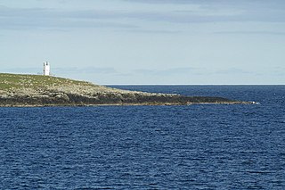
Lamba is an uninhabited island in Yell Sound in Shetland. It lies 1.5 km (0.93 mi) north of the entrance to the Sullom Voe inlet and 1.4 kilometres (0.87 mi) east of the Mainland coastline near Ollaberry. Rising 35 metres above sea level, it has an area of 43 hectares (0.17 sq mi). Its main features are a 27m high light marking the entrance to Sullom Voe, and an adjacent communications mast.
Sandness is a headland and district in the west of Shetland Mainland, Scotland. Sandness was a civil parish, which also included the island of Papa Stour some 1600 metres northwest across Papa Sound. In 1891, it was combined with Walls to the south, to form Walls and Sandness Parish, which had an administrative function until the abolition of Civil parishes in Scotland by the Local Government (Scotland) Act 1929, and had been a statistical regional unit since. Currently, the community council area of Sandness and Walls covers about the same area. The 1878 map of Sandness Parish shows that the parish to the east was Aithsting, before it was included into Sandsting to the south.
Linga is a small, uninhabited island, 1 km (0.62 mi) east of Muckle Roe in the Shetland Islands. The island is roughly circular in shape and its highest elevation is 69 metres (226 ft). Its area is 70 hectares (0.27 sq mi).
Uyea is an uninhabited tidal island located to the northwest of Mainland, Shetland. Uyea lies off the Northmavine peninsula, from where it can be reached by foot at low tide. The island's highest elevation is 70 metres (230 ft) and its area is 45 hectares (0.17 sq mi).
The Scalloway Islands are in Shetland opposite Scalloway on south west of the Mainland. They form a mini-archipelago and include:
This page is based on this Wikipedia article Text is available under the CC BY-SA 4.0 license; additional terms may apply. Images, videos and audio are available under their respective licenses.